
Mansac
| Mansac | ||
|---|---|---|
.svg)
|
|
|
| region | Nouvelle-Aquitaine | |
| Department | Corrèze | |
| Arrondissement | Brive-la-Gaillarde | |
| Canton | Saint-Pantaléon-de-Larche | |
| Community association | Bassin de Brive | |
| Coordinates | 45 ° 10 ′ N , 1 ° 23 ′ E | |
| height | 88-243 m | |
| surface | 18.40 km 2 | |
| Residents | 1,427 (January 1, 2017) | |
| Population density | 78 inhabitants / km 2 | |
| Post Code | 19600 | |
| INSEE code | 19124 | |
 The school and community center |
||

Mansac is a municipality with 1427 inhabitants (as of January 1, 2017) in France . It belongs to the Nouvelle-Aquitaine region , the Corrèze department , the Brive-la-Gaillarde arrondissement and the Saint-Pantaléon-de-Larche canton .
Geography and infrastructure
Mansac is passed by the A89 autoroute . A connection to this expressway is located northeast of the settlement area or in the middle of the municipality marker. The neighboring municipalities are Yssandon in the north, Varetz in the northeast, Saint-Pantaléon-de-Larche in the east, Pazayac in the south, Terrasson-Lavilledieu and Cublac in the southwest and Brignac-la-Plaine in the west.
Population development
| year | 1962 | 1968 | 1975 | 1982 | 1990 | 1999 | 2008 | 2012 |
|---|---|---|---|---|---|---|---|---|
| Residents | 1.104 | 1,114 | 1,227 | 1,281 | 1,341 | 1.312 | 1,374 | 1,361 |
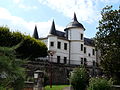
Château de la Choisne

Saint-Sigismond church
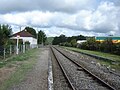
La Rivière de Mansac station on the Tulle - Coutras line

View of the Vézère


