Concèze
|
Concèze Concèsac |
||
|---|---|---|

|
|
|
| region | Nouvelle-Aquitaine | |
| Department | Corrèze | |
| Arrondissement | Brive-la-Gaillarde | |
| Canton | L'Yssandonnais | |
| Community association | Pays de Lubersac-Pompadour | |
| Coordinates | 45 ° 21 ′ N , 1 ° 21 ′ E | |
| height | 191-425 m | |
| surface | 13.44 km 2 | |
| Residents | 413 (January 1, 2017) | |
| Population density | 31 inhabitants / km 2 | |
| Post Code | 19350 | |
| INSEE code | 19059 | |
| Website | www.conceze.com | |
 Saint-Julien-de-Brioude church |
||
Concèze ( Occitan Concèsac ) is a French commune in the department of Corrèze in the region Nouvelle-Aquitaine . The inhabitants call themselves Concézan (e) , plural Concézans (es) .
geography
Concèze is located on the western edge of the Massif Central . Tulle , the prefecture of the department, is about 53 kilometers southeast, Brive-la-Gaillarde about 35 kilometers slightly southeast and Saint-Yrieix-la-Perche about 27 kilometers northwest.
Neighboring communities
Neighboring municipalities of Concèze are Beyssenac and Arnac-Pompadour in the north, Saint-Sornin-Lavolps in the east, Lascaux in the southeast, Chabrignac in the south, Juillac in the southwest and Saint-Cyr-les-Champagnes in the west.
traffic
Junction 45 to Autoroute A20 is about 27 kilometers to the north-east.
coat of arms
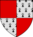
Description : The coat of arms is quartered . Heraldic top right and bottom left in red and in the other fields in ermine.
Population development
| year | 1962 | 1968 | 1975 | 1982 | 1990 | 1999 | 2009 | 2017 |
| Residents | 472 | 418 | 403 | 369 | 362 | 395 | 416 | 413 |
Attractions
- The Saint-Julien de Brioude church , a religious building from the 12th, 13th and 15th centuries, has been classified as a Monument historique since September 1, 1922 .
Web links
Individual evidence
- ↑ Entry no. PA00099744 in the Base Mérimée of the French Ministry of Culture (French)
