
Saint-Cernin-de-Larche
| Saint-Cernin-de-Larche | ||
|---|---|---|
.svg)
|
|
|
| region | Nouvelle-Aquitaine | |
| Department | Corrèze | |
| Arrondissement | Brive-la-Gaillarde | |
| Canton | Saint-Pantaléon-de-Larche | |
| Community association | Bassin de Brive | |
| Coordinates | 45 ° 6 ′ N , 1 ° 25 ′ E | |
| height | 105-312 m | |
| surface | 9.15 km 2 | |
| Residents | 648 (January 1, 2017) | |
| Population density | 71 inhabitants / km 2 | |
| Post Code | 19600 | |
| INSEE code | 19191 | |
 The Mairie |
||

Saint-Cernin-de-Larche , formerly Saint-Sernin-de-Larche, is a municipality in France . It belongs to the Nouvelle-Aquitaine region , the Corrèze department and the Brive-la-Gaillarde arrondissement . It borders on Larche to the north, Lissac-sur-Couze and Chasteaux to the east, Chartrier-Ferrière to the south and Chavagnac to the west .
The residents call themselves Saint-Cerninois or Saint-Cerninoises .
Attractions
- Dolmen de la Chassagne and Dolmen de La Palein , both monuments historiques
- Saint-Saturnin church, also a monument historique
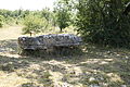
Dolmen de La Chassagne
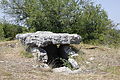
Dolmen de La Palein
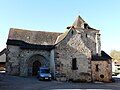
Saint-Saturnin Church
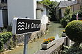
The Couze flows through Saint-Cernin-de-Larche


Population development
| year | 1962 | 1968 | 1975 | 1982 | 1990 | 1999 | 2008 | 2012 |
|---|---|---|---|---|---|---|---|---|
| Residents | 309 | 309 | 297 | 319 | 425 | 456 | 576 | 633 |
Web links
Commons : Saint-Cernin-de-Larche - Collection of images, videos and audio files