Pleșcuța (Arad)
|
Pleșcuța Peleskefalva |
||||
|
||||
| Basic data | ||||
|---|---|---|---|---|
| State : |
|
|||
| Historical region : | Screeching area | |||
| Circle : | Arad | |||
| Coordinates : | 46 ° 18 ' N , 22 ° 26' E | |||
| Time zone : | EET ( UTC +2) | |||
| Area : | 78.90 km² | |||
| Residents : | 1,219 (2011) | |||
| Population density : | 15 inhabitants per km² | |||
| Postal code : | 317260 | |||
| Telephone code : | (+40) 02 57 | |||
| License plate : | AR | |||
| Structure and administration (as of 2016) | ||||
| Community type : | local community | |||
| Structure : | Pleșcuța, Aciuța , Budești , Dumbrava , Gura Văii , Rostoci and Tălagiu | |||
| Mayor : | Groza Viorel Marius ( PNL ) | |||
| Postal address : | Str. Principală No. 82 loc. Pleșcuța, jud. Arad, RO-317260 |
|||
| Website : | ||||
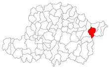
Pleșcuța (Hungarian: Peleskefalva ) is a municipality in Arad County , in the Kreischgebiet , in western Romania . The villages of Aciuța , Budeşti , Dumbrava , Gura Văii , Rostoci and Tălagiu also belong to the municipality of Pleșcuța .
Geographical location
Pleșcuța is located in the east of the Arad district, at the foot of the Codru-Moma Mountains in the Transylvanian Ore Mountains , 116 km from the district capital Arad .
Neighboring places
| Valea Mare | Zimbru , Vidra | Vârfurile |
| Feniș |

|
Bodeşti |
| Rostoci | Dumbrava | Aciuța |
history
The first written mention of Pleszkuca comes from 1439.
Over the centuries, various spellings of the name made their appearance: 1439 Pleszkuca , 1525 Pleska , 1760-762 Pleskucza , 1784 Pleskutza , Pliskotza , 1800 Pleskutza , 1817 Plefzkutza , 1827 Pleskutza , 1839 Pleskucza , 1839 Pleskutza , 1850 Pleskucza , 1850 Pleskutza , Pleskutza 1857 Pleskutza , Plăşcuţa , 1863 Pleskucza , 1873, 1877 Pleskuca , 1882 Pleskuca , Pleskucza , Plescutia , 1891, 1893, 1900 Pleskucza , 1909 Pleşcuţa , Pleskucza , 1910, 1913 Peleskefalva , 1921 Pleşcuţa , Peleskefalva , 1925, 1932, 1956 Pleşcuţa .
After the Peace of Karlowitz (1699), Arad and the Maroscher Land came under Austrian rule , while the Banat south of the Marosch remained under Turkish rule until the Peace of Passarowitz (1718) . On the Josephine land survey is Pleskutza entered. As a result of the Austro-Hungarian Compromise (1867), the Arad region, like the whole of Banat and Transylvania, was annexed to the Kingdom of Hungary within the Austro-Hungarian dual monarchy . The official place name was Pleskucza . The Treaty of Trianon on June 4, 1920 resulted in border regulation, whereby Pleșcuța fell to the Kingdom of Romania .
There are six quarries for the extraction of andesite on the area of the municipality of Pleșcuța . Most of the residents work in the quarries in the area.
Population development
| census | Ethnicity | |||||||
|---|---|---|---|---|---|---|---|---|
| year | Residents | Romanians | Hungary | German | Other | |||
| 1880 | 2930 | 2871 | 23 | 1 | 35 | |||
| 1910 | 3659 | 3558 | 92 | 1 | 8th | |||
| 1930 | 3348 | 3312 | 16 | 1 | 19th | |||
| 1977 | 2374 | 2373 | 1 | - | - | |||
| 1992 | 1796 | 1792 | 2 | - | 2 | |||
| 2002 | 1498 | 1496 | - | - | 59 | |||
Web links
- ghidulprimariilor.ro , Pleșcuța citizens' office
- virtualarad.net , Pleșcuța on VirtualArad
Individual evidence
- ↑ citypopulation.de , census October 20, 2011
- ↑ Mayoral elections 2016 in Romania ( MS Excel ; 256 kB)
- ↑ plescuta.ro , Pleșcuța municipality
- ↑ Pleșcuța on arcanum.hu
- ↑ virtualarad.net , Pleșcuța on VirtualArad
- ↑ kia.hu , E. Varga: Statistics of the population by ethnic group in the Arad district according to censuses from 1880 - 2002


