
Ploscoș
|
Ploscoș Palackos |
|||||
|
|||||
| Basic data | |||||
|---|---|---|---|---|---|
| State : |
|
||||
| Historical region : | Transylvania | ||||
| Circle : | Cluj | ||||
| Coordinates : | 46 ° 39 ' N , 23 ° 51' E | ||||
| Time zone : | EET ( UTC +2) | ||||
| Height : | 345 m | ||||
| Area : | 41.66 km² | ||||
| Residents : | 702 (October 20, 2011) | ||||
| Population density : | 17 inhabitants per km² | ||||
| Postal code : | 407465 | ||||
| Telephone code : | (+40) 02 64 | ||||
| License plate : | CJ | ||||
| Structure and administration (as of 2016) | |||||
| Community type : | local community | ||||
| Structure : | Ploscoș, Crairât , Lobodaș , Valea Florilor | ||||
| Mayor : | Aurel Truță ( PNL ) | ||||
| Postal address : | Str. Principală, no. 50 loc. Ploscoș, jud. Cluj, RO-407465 |
||||
| Website : | |||||


Ploscoș [ ˈploskoʃ ] ( Hungarian Palackos ) is a municipality in Cluj County , in Transylvania , Romania .
Geographical location

The municipality of Ploscoș is located in the southwest of the Transylvanian Heath (Câmpia Transilvaniei) - part of the Transylvanian Basin , northeast of the Cămărașului mountain (Dealul Cămărașului; 493 m ). On the brook Pârâul Florilor - a left tributary of the Arieș Arieș - on the county road (Drum județean) DJ 161B and on the railway line Cluj-Napoca-Războieni , the place Ploscoș is 15 kilometers north of the city of Câmpia Turzii (Jerischmarkt) and about 40 Kilometers southeast of the district capital Cluj-Napoca (Klausenburg) .
Because of the salt deposits in the region, there are salt marshes in the flat valleys of the municipality and salt is exposed on some of the slippery slopes. The municipality's region is one of the poorest in Transylvania.
history
The place Ploscoş was first mentioned in 1913.
An archaeological find on the area of the incorporated village of Valea Florilor (Hungarian Virágosvölgy ) points to the Neolithic , according to Márton Roska . According to the Romanian Ministry of Culture, a settlement from the Hallstatt period and a barrow from prehistory have been found north of the village during archaeological excavations .
In the Kingdom of Hungary , today's municipality was in the Torda district (today Turda ) in the Torda-Aranyos County . Subsequently, the municipality belonged to the historical district of Turda and from 1950 to today's district of Cluj.
Today's community center consists of the former village of Ploscoş and the hamlets of Adămeşti , Drăculeşti , Șerpeşti , Valea Crişeni , Valea Întunecată , Valea Lungă Mare and Valea Vântului . The hamlet of Costeşti is assigned to the village of Lobodaş (Hungarian Labodás ) and the hamlets of Bicaş , Bogomirea , Cantonu Gării and Valea Sărată are assigned to the incorporated village of Valea Florilor .
population
In the area of today's municipality of Ploscoș, almost exclusively Romanians have been registered since 1956 . In 1956 there were 2236 Romanians of the 2316 inhabitants, 59 Magyars (at the same time the highest number), 19 Roma (at the same time the highest number) and one Romanian German - the only one who was ever registered. The highest number of Romanians (2258) was recorded in 1966. In the 2002 census, only 796 Romanians and one Hungarian were registered in the municipality. In the 2011 census, of the 702 people, 664 Romanians, 12 Roma and the remaining 26 gave no information about their ethnicity .
The main occupation of the population is agriculture and livestock.
Attractions
In the area of the municipality of Ploscoş there are no noteworthy sights.
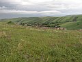
View of Ploscoș
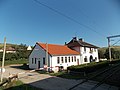
Railway station in Valea Florilor

Wooden church in Valea Florilor


Web links
Individual evidence
- ↑ a b 2011 census in Romania ( MS Excel ; 1.3 MB)
- ↑ a b Heinz Heltmann, Gustav Servatius (Ed.): Travel Guide Siebenbürgen . Kraft, Würzburg 1993, ISBN 3-8083-2019-2 , p. 517 .
- ^ Institute Of Archeology - Valea Florilor (Romanian). Retrieved January 5, 2018
- ↑ List of historical monuments of the Romanian Ministry of Culture, updated 2015 (PDF; 12.7 MB; Romanian)
- ↑ Censuses 1850–2002, last updated November 2, 2008 (PDF; 1 MB; Hungarian)
Aghireșu | Aiton | Aluniș | Apahida | Aşchileu | Baciu | Băișoara | Beliș | Bobâlna | Bonțida | Borșa | Buza | Căianu | Călărași | Călățele | Cămărașu | Căpușu Mare | Cășeiu | Câțcău | Cătina | Ceanu Mare | Chinteni | Chiuieşti | Ciucea | Ciurila | Cojocna | Cornești | Cuzdrioara | Dăbâca | Feleacu | Fizeșu Gherlii | Florești | Frata | Gârbău | Geaca | Gilău | Iara | Iclod | Izvoru Crișului | Jichișu de Jos | Jucu | Luna | Măguri-Răcătău | Mănăstireni | Mărgău | Mărișel | Mica | Mihai Viteazu | Mintiu Gherlii | Mociu | Moldoveneşti | Negreni | Pălatca | Panticeu | Petreștii de Jos | Ploscoș | Poieni | Râșca | Recea-Cristur | Săcuieu | Sâncraiu | Sănduleşti | Sânmărtin | Sânpaul | Săvădisla | Sic | Suatu | Țaga | Tritenii de Jos | Tureni | Unguraș | Vad | Valea Ierii | Viișoara | Vultureni