
Alberndorf in the Riedmark
|
Alberndorf in the Riedmark
|
||
|---|---|---|
| coat of arms | Austria map | |
 |
|
|
| Basic data | ||
| Country: | Austria | |
| State : | Upper Austria | |
| Political District : | Urfahr environment | |
| License plate : | UU | |
| Surface: | 40.37 km² | |
| Coordinates : | 48 ° 24 ' N , 14 ° 25' E | |
| Height : | 570 m above sea level A. | |
| Residents : | 4,180 (January 1, 2020) | |
| Population density : | 104 inhabitants per km² | |
| Postal code : | 4211 | |
| Area code : | 07235 | |
| Community code : | 4 16 01 | |
| NUTS region | AT312 | |
| Address of the municipal administration: |
Kalchgruberstraße 2 4211 Alberndorf in der Riedmark |
|
| Website: | ||
| politics | ||
| Mayor : | Martin Tanzer ( ÖVP ) | |
|
Municipal Council : (2015) (25 members) |
||
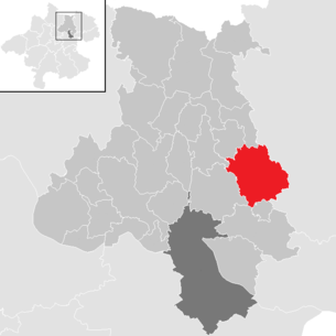
| Location of Alberndorf in Riedmark in the Urfahr-Umgebung district | ||
  |
||
 Alberndorf seen from the north-east |
||
| Source: Municipal data from Statistics Austria | ||

Alberndorf in der Riedmark is a municipality with 4180 inhabitants (as of January 1, 2020) in Upper Austria in the Urfahr-Umgebung district in the upper Mühlviertel . The community is located in the judicial district of Urfahr .
geography
Alberndorf in the Riedmark lies at an altitude of 570 m above sea level. A. in the upper Mühlviertel . The extension is 8.1 km from north to south and 8.3 km from west to east. The total area is 40.5 km².
Area division:

Community structure
The municipality includes the following localities (population in brackets as of January 1, 2020):
- Aich (48)
- Alberndorf in der Riedmark (749)
- Almesberg (276)
- Berbersdorf (79)
- Gerbersdorf (44)
- Grasbach (336)
- Greifenberg (7)
- Hadersdorf (77) including Schwarzau
- Heinberg (48)
- Deer Stone (28)
- Kelzendorf (134)
- Klamleiten (35) including Bruckmühle
- Kottingersdorf (62)
- Lindach (132)
- Loitzendorf (141)
- Luegstetten (60)
- Matzelsdorf (56)
- Oberndorf (3)
- Oberweitersdorf (62)
- Pröselsdorf (375)
- Riedegg (199)
- Rinzendorf (183)
- Schallersdorf (4)
- Schlammersdorf (117)
- Spattendorf (452)
- Steinbach (50)
- Veitsdorf (177)
- Weikersdorf (51)
- Zeurz (195) including Oberzeurz and Unterzeurz
Neighboring communities
|
Haibach in the Mühlkreis Hellmonsödt |
Ottenschlag in the Mühlkreis | Neumarkt in the Mühlkreis |
| Altenberg near Linz |
.svg)
|
|
| Engerwitzdorf | Gallneukirchen | Unterweitersdorf |
history
Originally located in the eastern part of the Duchy of Bavaria, the place has belonged to the Duchy of Austria since the 12th century and to the Principality of Austria ob der Enns since 1490 .
Albandorf was first mentioned in a document around 1417, the name being derived from the Old High German personal name Albani. In the 17th century the place name to the Middle High German term for was alber poplar meaning "village near poplars" reinterpreted folk etymology.
After Austria was annexed to the German Reich on March 13, 1938, Upper Austria became the Gau Oberdonau . After 1945, Upper Austria was restored .
Population development
| year | Residents | change | percentage change |
|---|---|---|---|
| 2018 | 4083 | +135 | + 3% |
| 2015 | 3948 | +76 | + 2% |
| 2011 | 3872 | +288 | + 8% |
| 2001 | 3584 | +425 | + 13% |
| 1991 | 3159 |
Culture and sights

Regular events
- Since 2003 the community has organized the Alberndorfer Kulturtage every year .
- Since 2007, the municipality has been awarding the AKUT poetry / prose / fairy tale prize annually .
politics
Municipal council
- Composition of the municipal council: Result of the election on September 27, 2015:
Eligible to vote: 3,221, valid votes: 2671, invalid votes: 97, voter turnout: 85.94%
| Political party | percent | be right | Mandates | |||
|---|---|---|---|---|---|---|
| ÖVP | 65.52% | + 2.65% | 1750 | +175 | 17th | +1 |
| SPÖ | 17.93% | -4.03% | 479 | -71 | 4th | -1 |
| FPÖ | 16.55% | +1.38% | 442 | +62 | 4th | +0 |
- Composition of the municipal council: Result of the election on September 27, 2009 :
Eligible to vote: 3,054, valid votes: 2,505, invalid votes: 84, voter turnout: 84.77%
| Political party | percent | be right | Mandates | |||
|---|---|---|---|---|---|---|
| ÖVP | 62.87% | +5.01% | 1575 | +335 | 16 | +1 |
| SPÖ | 21.96% | -12.62% | 550 | -191 | 5 | -4 |
| FPÖ | 15.17% | +7.61% | 380 | +218 | 4th | +3 |
mayor

Data from the homepage of the Province of Upper Austria
coat of arms
Blazon : from green and red by a golden branch with a golden leaf of the white poplar turned upwards and downwards at the bottom. The community colors are green-yellow-red.
Town twinning
-
 Wackersdorf in Bavaria , Germany
Personalities
Sons and daughters of the church
- Michael Huemer (1777–1849), " peasant lawyer "
- Ingrid Oberkanins (* 1964), musician
Personalities associated with the community
- Gotho Griesmeier (* 1971), opera singer, lives in Alberndorf
Web links
- 41601 - Alberndorf in the Riedmark. Community data, Statistics Austria .
- Further information about the municipality of Alberndorf in the Riedmark can be found on the geographic information system of the federal state of Upper Austria .
- Map in the Digital Upper Austrian Room Information System ( DORIS )
- Literature on Alberndorf in the forum OoeGeschichte.at
Individual evidence
- ↑ Statistics Austria - Population at the beginning of 2002–2020 by municipalities (area status 01/01/2020)
- ↑ Statistics Austria: Population on January 1st, 2020 by locality (area status on January 1st, 2020) , ( CSV )
- ↑ Karl Hohensinner and Peter Wiesinger : Place Name Book of the Province of Upper Austria 10. The place names of the political district Urfahr-Umgebung (Middle Mühlviertel). Vienna 2006
- ^ State of Upper Austria, history and geography, coat of arms. Retrieved April 27, 2019 .
- ^ Community Alberndorf in the Riedmark, home page. Retrieved April 27, 2019 .

Alberndorf in the Riedmark | Altenberg near Linz | Bad Leonfelden | Eidenberg | Engerwitzdorf | Feldkirchen an der Donau | Gallneukirchen | Goldwörth | Gramastetten | Haibach im Mühlkreis | Hellmonsödt | Herzogsdorf | Kirchschlag near Linz | Lichtenberg | Oberneukirchen | Ottenschlag in the Mühlkreis | Ottensheim | Puchenau | Reichenau im Mühlkreis | Reichenthal | Schenkenfelden | Sonnberg in the Mühlkreis | St. Gotthard in the Mühlkreis | Steyregg | Vorderweißbach | Walding | Zwettl on the Rodl