
Reinberg (Sundhagen)
|
Reinberg
Sundhagen municipality
Coordinates: 54 ° 13 ′ 0 ″ N , 13 ° 15 ′ 0 ″ E
|
||
|---|---|---|
| Height : | 12 m | |
| Area : | 25.14 km² | |
| Residents : | 652 (December 31, 2015) | |
| Population density : | 26 inhabitants / km² | |
| Incorporation : | June 7, 2009 | |
| Postal code : | 18519 | |
| Area code : | 038328 | |
Location of Reinberg in Mecklenburg-Western Pomerania |
||

Reinberg is a district of the municipality of Sundhagen , which belongs to the district of Vorpommern-Rügen in Mecklenburg-Western Pomerania .

geography
Reinberg is located between Stralsund (16.8 kilometers) and Greifswald (17.7 kilometers) directly on the current federal highway 105 , the former B 96. The town and its surroundings are on slightly undulating terrain with 5.7 to 17.6 meters about NHN .
history
Although the tower hill castle to the west of the village can be assigned to the early German period (1200 to 1350), finds also show the presence of a settlement or a rampart from the late Slavic period ( Vipperower ceramics from 1000 to 1200) at this location.
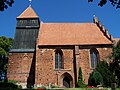
The construction of the church began in 1220 and Reinberg was only mentioned in documents in 1325 and 1353. The church is located in the center of the village on a hill bordered by a stone wall.
After the ruling dynasty in the Principality of Rügen died out in 1325, the place with the Principality and the mainland part came as an inheritance to the Duchy of Pomerania .
As with Kirchdorf, lands around Reinberg were bought up by Greifswald citizens. After 1353 they sold or donated these to the city and the Heilig-Geist-Hospital Greifswald. Both had this from Duke Wartislaw IX. 1418 confirm. The place subsequently developed into an estate and Büdnerdorf as well as a church and parish seat. The term “Gut” was not used here, but “Vorwerk” because it was not privately owned, but was owned by a municipality or a social institution who leased the property.
The estate / Vorwerk was located separately approx. 750 meters southwest of the town center.
In 1670 a visit was ordered for the place without Gut / Vorwerk. This resulted in: 1 windmill and 1 water mill, 1 blacksmith, 2 farmers with a sideline “Krüger” (innkeepers), 12 cottage workers - these were linen weavers, tailors, wheel makers and day laborers.
In 1806 the farms were laid in favor of the estate / Vorwerk. The previous tenants were only supposed to run the beer taverns. However, the Napoleonic Wars (1806 to 1813) repeatedly drove the new tenants to ruin.
After the Thirty Years War until 1815, Reinberg belonged to Swedish Pomerania and then to the Prussian province of Pomerania .
It wasn't until 1835 that the situation changed for the jug leaseholders in Reinberg, the road from Greifswald to Stralsund (later B 96 - then B 105) was completed and the jug was also to become a post office. However, this required a relocation of the site and a new building. With the help of the city of Greifswald as the owner, the new building at the new location on the street was realized in stages from 1837 to 1855.
Another expropriation took place in 1856 when the communal pasture was abolished; there were small compensations, but most of the land went to the estate / Vorwerk.
In 1866 the estate / Vorwerk had 436 acres, 56 acres belonged to the "reservations" (?) - this included e.g. B. the mill farm, of the 10 still registered Büdners 5 had one to 4 acres and the remaining 5 Büdners far less than one morning. The church, the parish farm and the Küsterhof had 256 acres in common. This possession was doubted because of the legality because it seemed too much, but not changed.
The tenants of the estate / Vorwerk were: 1850 Theodor Westphal, 1851 Carl Langemark, 1857 W. Holsten and 1862 Ziemssen. In 1866 the estate consisted of a manor house, 3 stables or barns, a cottage with a stable and a post mill.
In 1871 Reinberg had 19 houses in which 36 families with 172 inhabitants lived. Shortly before 1867, 197 people were still living there. All were of the Protestant religion, Catholics and Jews did not exist.
From 1835 according to Prussia. According to the measurement table sheet, the place "Langenhinrichshagen" was moved from the northwest of Reinberg to the northern edge of the place until 1880 and was given the name "Niederhinrichshagen". Two large farms were established there, which were expanded as manors by 1920. The ownership structure of these farms is unclear, they probably did not belong to the city of Greifswald because they are not listed there. Until after 1920, this residential area "Niederhinrichshagen" belonged to Reinberg, which was then integrated directly into Reinberg.
To the east of the church is a relatively compact rectory (rectory) that is still managed today.
In the course of the land reform , the estate became a city property after 1945 first state then public property . The estate was settled. On July 1, 1950, the previously independent municipality of Stahlbrode was incorporated. New farmer settlements were built up until the 1950s . During the GDR era, the place expanded with these new farmsteads towards the southwest and later with residential areas especially towards the north. The manor is only present in relics, the manor house is standing and the park is still partially preserved.
An agricultural complex was built between Reinberg and Falkenhagen in the 1980s, which was expanded and modernized after 1990 and now functions as a commercial area.
Reinberg belonged to the state of Mecklenburg , from July 25, 1952 to the Rostock district and from October 3, 1990 to the state of Mecklenburg-Western Pomerania. Until June 11, 1994 it was in the district of Grimmen in its respective area and then in the district of North Western Pomerania .
On June 7, 2009, the previously independent community of Reinberg merged with the communities of Behnkendorf , Brandshagen , Horst , Kirchdorf , Miltzow and Wilmshagen to form the new community of Sundhagen. The community consisted of the districts Oberhinrichshagen, Falkenhagen and Dömitzow as well as Stahlbrode, which was incorporated on July 1, 1950.
Landmarks and monuments
Worth seeing in Reinberg are:
- the Gothic village church
The Reinberg village church is a Gothic brick church from the 13th century
- the atonement stone
on the cemetery wall from the 15th century. The atonement stone bears a kneeling figure, hands clasped next to Christ on the cross. Above the cross, between two roses, the initials "JNRJ" and the words: "domini miserere mei". The weathered inscription above the crucified was probably originally: "orate pro ravno van barneko". There is also the reading "orate pro heyno van der beken", but a van der Beken family is not documented. The princely councilor and bailiff Raven Barnekow, on the other hand, who was sentenced to death in Stralsund in March 1453 after false accusations and dragged to death behind a horse and then his body was braided onto the bike. The mayor of Stralsund Vuge, who was accused of the crime, was expelled from the country after a court order of 1470 and his 6 goods were confiscated. The city of Stralsund was sentenced to a gold penalty and had to take Barnekov's bones off the bike, put them on a stretcher and bring them with 600 people as a funeral procession from Stralsund to Greifswald. Only the church in Reinberg was allowed to be used as a resting point; The train then had to go without interruption to the city limits of Greifswald, where the stretcher was handed over. A memorial stone for Raven Barnekow still stands here today. So this is supposed to be the story of the Reinberg Atonement Stone.
- the Reinberger Linde
In the 19th century, the Reinberger linden was considered the largest tree in Germany. The age of the tree is around 1000 years. The linden tree may have been planted before the church was founded and consecrated. Near the tree is located
- the tomb
Grave of the father of the surgeon Theodor Billroth .
- Fallen memorial
The memorial to those who died in World War I is missing the writing plate.
- the Reinberg tower
former tower hill castle in the middle of a large complex in the river bend.
→ See also the list of architectural monuments in Sundhagen
Reinberg village church

Atonement stone from Reinberg

Reinberger linden tree

Reinberger Linde in front of the north side of the church
.JPG)


Economy and Infrastructure
traffic
The federal highway 96 ran through the place until the 1970s , which was then moved with the bypass to the west of the place and was renamed to the federal highway 105 after 2000. Seasonally, a car ferry runs from the former district of Stahlbrode to the island of Rügen in Glewitz on the ( Zudar peninsula ), and state road 30 has been modernized to become a ferry station.
literature
- Heinrich Berghaus : Land book of the Duchy of Pomerania and the Principality of Rügen. IV. Theil, Volume I, Greifswald district (general) - especially “City of Greifswald and the royal. University there ”, Anklam / Berlin 1866.
- Royal Statistical Bureau, “Municipalities and manor districts and their population”, III. Province of Pomerania, census of December 1, 1871, Berlin 1874.
Web links
Individual evidence
- ↑ StBA: Area changes from January 2nd to December 31st, 2009
- ^ Society for Pomeranian History and Archeology (ed.): The architectural monuments of the province of Pomerania. Part 1: Ernst von Haselberg : The monuments of the government district of Stralsund. Issue 1: The Franzburg District. Paul Saunier, Stettin 1881, p. 238.
- ↑ Julius von Bohlen-Bohlendorf : The bishop rye and the goods of the Diocese Roeskild on Rügen in the hereditary possession of the Barnekow and outline of the history of this noble, baronial and countess family. E. Hingst, Stralsund 1850, p. 175 ff.
- ^ Heinrich Berghaus : Land book of the Duchy of Pomerania and the Principality of Rügen. IV. Theil, Volume I, Greifswald district (general) - especially “City of Greifswald and the royal. University there ”, Anklam / Berlin 1866, page 652 ff.