Saint-Juvat
|
Saint-Juvat Sant-Yuvad |
||
|---|---|---|
|
|
||
| region | Brittany | |
| Department | Cotes-d'Armor | |
| Arrondissement | Dinan | |
| Canton | Lanvallay | |
| Community association | Dinan agglomeration | |
| Coordinates | 48 ° 21 ′ N , 2 ° 3 ′ W | |
| height | 13-71 m | |
| surface | 17.41 km 2 | |
| Residents | 653 (January 1, 2017) | |
| Population density | 38 inhabitants / km 2 | |
| Post Code | 22630 | |
| INSEE code | 22308 | |
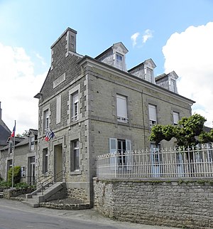
 Town hall (Mairie) and school of Saint-Juvat |
||
Saint-Juvat ( Breton : Sant-Yuvad ; Gallo : Saent-Juvat ) is a French municipality with 653 inhabitants (as of January 1 2017) in Côtes-d'Armor , in the region of Brittany . The municipality belongs to the Arrondissement of Dinan and the canton of Lanvallay (until 2015: canton of Évran ). The inhabitants are called Juvatiens .
geography
Saint-Juvat is about ten kilometers south of Dinan . The river Rance limits the community to the east. Saint-Juvat is surrounded by the neighboring communities of Trévron in the north, Calorguen in the north and north-east, Saint-André-des-Eaux in the east and north-east, Le Quiou in the east and south-east, Tréfumel in the south and south-east, Saint-Maden in the south-west and Plumaudan in the West.
Demographics
| Population development | ||||||||
|---|---|---|---|---|---|---|---|---|
| year | 1962 | 1968 | 1975 | 1982 | 1990 | 1999 | 2006 | 2013 |
| Residents | 774 | 704 | 652 | 664 | 678 | 648 | 626 | 648 |
|
Source: INSEE
|
||||||||
Attractions
See also: List of Monuments historiques in Saint-Juvat
- Saint-Juvat church from the 14th century
- Several stone crosses
literature
- Le Patrimoine des Communes des Côtes-d'Armor. Flohic Editions, Volume 1, Paris 1998, ISBN 2-84234-017-5 , pp. 353-357.

