
Guenroc
|
Guenroc Gwenroc'h |
||
|---|---|---|
.svg)
|
|
|
| region | Brittany | |
| Department | Cotes-d'Armor | |
| Arrondissement | Dinan | |
| Canton | Broons | |
| Community association | Dinan agglomeration | |
| Coordinates | 48 ° 19 ′ N , 2 ° 4 ′ W | |
| height | 23-103 m | |
| surface | 7.39 km 2 | |
| Residents | 220 (January 1, 2017) | |
| Population density | 30 inhabitants / km 2 | |
| Post Code | 22350 | |
| INSEE code | 22069 | |
| Website | http://guenroc.mairie.pagespro-orange.fr/ | |

Guenroc ( Breton : Gwenroc'h ) is a French commune with 220 inhabitants (as of January 1, 2017) in the Côtes-d'Armor department in the Brittany region . It belongs to the Arrondissement of Dinan and the Canton of Broons . The residents call themselves Guenrocois (es) .
geography
Guenroc is located about 37 kilometers northwest of Rennes in the east of the Côtes-d'Armor department. At the southern border of the municipality, the river Rance runs as a reservoir of the Barrage de Rophemel . In the far south-west the Frémeur flows into the Rance.
history
Several finds from the Celtic and Gallo-Roman times prove an early settlement. In the Middle Ages there were several feudal lords. The first noble family were the lords of Guenroc, the community belonged to the Dinan district from 1793 to 1801. It was also part of the canton of Trefumel from 1793 to 1801, then from 1801 to 1881 of the canton of Saint-Jouan-de-l'Ille and from 1881 to 2015 of the canton of Caulnes . Since 1801, Guenroc has been administratively part of the Arrondissement of Dinan. First mention of Guenroc by name during an official investigation into legal claims in 1286.
Population development
| year | 1793 | 1800 | 1831 | 1836 | 1846 | 1911 | 1921 | 1936 | 1962 | 1968 | 1975 | 1982 | 1990 | 1999 | 2006 | 2012 |
| Residents | 569 | 433 | 570 | 526 | 587 | 412 | 350 | 339 | 268 | 249 | 193 | 185 | 176 | 195 | 183 | 214 |
| Sources: Cassini and INSEE | ||||||||||||||||
The increasing mechanization of agriculture and the high number of those who died in the First World War led to a drop in the number of inhabitants to the lows of recent times.
Attractions
- Village church of Saint-Gervais et Saint-Protais (built 1465 or 1475, restored in the 18th century)
- Cross by Le Defas (also Les Défas / Dol / Beaumelin) from the 17th century
- several mansions: Cariou (built 1634), Giguais (15th / 16th century), Lattay and Launay ou L'Aulnaie
- the former rectory
- older houses in the village center and in Giguais
- Saint Jarnoüen village fountain
- Market / factory halls from 1649
- Memorial to the Fallen
- the quartz rock Le Roc Blanc with the cross

Town hall (Mairie) of Guenroc
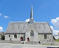
Guenroc village church

Guenroc Market Hall

old house in Guenroc

Quartz stone Le Roc Blanc with cross
_Mairie.JPG)
_%C3%89glise_01.JPG)
_Halles.JPG)
_Maison_ancienne.JPG)

literature
- Le Patrimoine des Communes des Côtes-d'Armor. Flohic Editions, Volume 1, Paris 1998, ISBN 2-84234-017-5 , pp. 124-127.
Web links
- Location of the municipality
- Brief information about the community
- Photos of the village church of Saint-Gervais et Saint-Protais
- Information about the history and the sights
Individual evidence
- ↑ Description of the sights (French) ( Memento of the original from September 17, 2016 in the Internet Archive ) Info: The archive link was inserted automatically and has not yet been checked. Please check the original and archive link according to the instructions and then remove this notice.
- ↑ Memorial to the fallen of the two world wars