Plorec-sur-Arguenon
|
Plorec-sur-Arguenon Ploareg |
||
|---|---|---|

|
|
|
| region | Brittany | |
| Department | Cotes-d'Armor | |
| Arrondissement | Dinan | |
| Canton | Plancoët | |
| Community association | Dinan agglomeration | |
| Coordinates | 48 ° 29 ′ N , 2 ° 18 ′ W | |
| height | 7-88 m | |
| surface | 13.65 km 2 | |
| Residents | 414 (January 1, 2017) | |
| Population density | 30 inhabitants / km 2 | |
| Post Code | 22980 | |
| INSEE code | 22205 | |
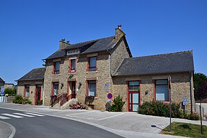
 Mairie Plorec-sur-Arguenon |
||
Plorec-sur-Arguenon ( Breton : Ploareg ) is a municipality with 414 inhabitants (as of January 1 2017) in the department of Côtes-d'Armor of the region Brittany in northwest France . Plorec-sur-Arguenon belongs to the Arrondissement of Dinan and the canton of Plancoët (until 2015: canton of Plélan-le-Petit ). The inhabitants are called Plélanais .
geography
Plorec-sur-Arguenon is about 25 kilometers west-northwest of Dinan . The Arguenon limits the municipality in the west with its sea-like extension. Plorec-sur-Arguenon is surrounded by the neighboring communities of Pluduno in the north, Bourseul in the east and north-east, Jugon-les-Lacs in the south and south-east, Plédéliac in the west and south-west and Pléven in the north-west.
Population development
| year | 1793 | 1846 | 1896 | 1911 | 1946 | 1962 | 1968 | 1975 | 1982 | 1990 | 1999 | 2006 | 2016 |
| Residents | 816 | 866 | 932 | 785 | 660 | 619 | 551 | 502 | 503 | 473 | 398 | 396 | 412 |
| Source: Cassini and INSEE | |||||||||||||
Attractions
- Saint-Pierre church
- Tumulus , Monument historique
literature
- Le Patrimoine des Communes des Côtes-d'Armor. Flohic Editions, Volume 2, Paris 1998, ISBN 2-84234-017-5 , p. 879.
Web links
Commons : Plorec-sur-Arguenon - collection of images, videos and audio files

