
Saint-Privat-de-Champclos
| Saint-Privat-de-Champclos | ||
|---|---|---|
.svg)
|
|
|
| region | Occitania | |
| Department | Gard | |
| Arrondissement | Alès | |
| Canton | Rousson | |
| Community association | Cèze Cévennes | |
| Coordinates | 44 ° 17 ′ N , 4 ° 22 ′ E | |
| height | 90-279 m | |
| surface | 11.64 km 2 | |
| Residents | 344 (January 1, 2017) | |
| Population density | 30 inhabitants / km 2 | |
| Post Code | 30430 | |
| INSEE code | 30293 | |
.JPG) Mairie Saint-Privat-de-Champclos |
||

Saint-Privat-de-Champclos is a commune in the French department of Gard in the Occitanie region (before 2016 Languedoc-Roussillon ). It belongs to the canton of Rousson in the Arrondissement of Alès . Neighboring municipalities are Barjac in the north, Montclus in the east, Méjannes-le-Clap in the southeast, Tharaux in the southwest and Saint-Jean-de-Maruéjols-et-Avéjan in the west.
Population development
| year | 1962 | 1968 | 1975 | 1982 | 1990 | 1999 | 2008 | 2017 |
|---|---|---|---|---|---|---|---|---|
| Residents | 210 | 173 | 173 | 189 | 212 | 203 | 305 | 344 |
Attractions
- Saint-Privat Church
- Notre-Dame-des-Lumières de Cavène chapel
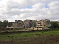
- Castle ruins of Château de Ferreyroles

Saint-Privat Church

Notre-Dame-des-Lumières de Cavène chapel

Castle ruins of Château de Ferreyroles
Cabiac outskirts

.JPG)

.JPG)
Web links
Commons : Saint-Privat-de-Champclos - Collection of images, videos and audio files