
Saint-Jean-du-Pin
|
Saint-Jean-du-Pin Sent Joan del Pin |
||
|---|---|---|
|
||
| region | Occitania | |
| Department | Gard | |
| Arrondissement | Alès | |
| Canton | Alès-1 | |
| Community association | Alès agglomeration | |
| Coordinates | 44 ° 7 ' N , 4 ° 3' E | |
| height | 159-561 m | |
| surface | 13.96 km 2 | |
| Residents | 1,511 (January 1, 2017) | |
| Population density | 108 inhabitants / km 2 | |
| Post Code | 30480 | |
| INSEE code | 30270 | |
| Website | http://www.saint-jean-du-pin.fr/ | |
 Town hall (Mairie) of Saint-Jean-du-Pin |
||

Saint-Jean-du-Pin ( Occitan : Sent Joan del Pin ) is a French commune with 1,511 inhabitants (as of January 1, 2017) in the Gard department in the Occitanie region . The municipality belongs to the arrondissement of Alès and is part of the canton of Alès-1 (until 2015: canton of Alès-Ouest ). The inhabitants are called Pinois .
geography
Saint-Jean-du-Pin is a banlieue in the west (approx. Two kilometers from the city center) of Alès . Saint-Jean-du-Pin is surrounded by the neighboring communities of Cendras in the north, Alès in the east, Saint-Christol-lez-Alès in the south and south-east, Bagard in the south, Générargues in the south-west, and Saint-Sébastien-d'Aigrefeuille in the west as well Saint-Paul-la-Coste in the north-west.
Population development
| 1962 | 1968 | 1975 | 1982 | 1990 | 1999 | 2006 | 2013 |
|---|---|---|---|---|---|---|---|
| 779 | 790 | 847 | 1,131 | 1,231 | 1,219 | 1,277 | 1,426 |
| Sources: Cassini and INSEE | |||||||
Attractions
- Saint-Jean church
- Sauvage Castle
- Burial mound from around 2,500 BC
- The Moncalm dolmens are located in the woods of the hamlet of La Cabane, west of Saint-Jean-du-Pin.

Saint-Jean church
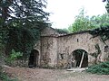
Sauvage Castle

