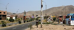
Santa Rosa District (Lima)
| Santa Rosa District | |||
|---|---|---|---|
 Location of the district in the province of Lima |
|||
| Symbols | |||
|
|||
| Basic data | |||
| Country | Peru | ||
| region | region free | ||
| province | Lima | ||
| Seat | Santa Rosa | ||
| surface | 21.5 km² | ||
| Residents | 27,863 (2017) | ||
| density | 1296 inhabitants per km² | ||
| founding | February 6, 1962 | ||
| ISO 3166-2 | PE | ||
| Website | www.munisantarosa-lima.gob.pe (Spanish) | ||
| politics | |||
| Alcalde District | Alan Carrasco Bobadilla (2019-2022) |
||
| Political party | Partido Democrático Somos Perú | ||
Coordinates: 11 ° 47 ′ 58 " S , 77 ° 10 ′ 31" W
The Santa Rosa district is one of the 43 urban districts of the Lima Metropolitana region in Peru . It covers an area of 21.5 km². The 2017 census counted 27,863 residents. In 1993 the population was 3,903, in 2007 it was 10,903.
Geographical location
The Santa Rosa district is located on a bay in the north of the Lima province . It has a coastline of around 5.5 km and extends only 4.5 km inland. The national road 1N ( Panamericana ) runs along the northeastern district border. The hills on the southern district border reach heights of up to 435 m .
The Santa Rosa district borders on the Ancón district to the north and east and the Ventanilla district in Callao to the south .
Web links
Commons : Santa Rosa District - Collection of images, videos and audio files
- Municipalidad Distrital de Santa Rosa
- Peru: Region Lima (provinces and districts) at www.citypopulation.de


