
Urban development in Cologne

Since its foundation in Rome almost 2000 years ago, the city of Cologne has developed into a metropolis on the Rhine. There the city today shows the emblematic Rhine panorama with the old town , the cathedral , the Romanesque church Groß St. Martin and the Hohenzollern Bridge . Other defining urban spaces include the area around the cathedral , the inner city belt of the Cologne rings and the inner green belt . These unmistakable spaces give Cologne the format of a major European city ; however, they have only emerged since the end of the 18th century.
The development of Cologne up to industrialization
The Roman city plan

Early settlements in the Cologne area were expanded and fortified by the Romans and raised to the status of Colonia Claudia Ara Agrippinensium (CCAA) in 50 AD . The core of the settlement at that time lay on a high plateau and was therefore protected from flooding. An offshore island offered a natural harbor for use. The city prospered not only as a regional administrative center, but also as a supra-regional center of handicrafts, especially for the glass industry, and as a trading center where five important Roman roads crossed with the waterway that was also used at the time. In its heyday, between 15,000 and 20,000 inhabitants lived in the Roman Colonia.
The Roman floor plan, laid out in a geometric grid, can still be read in the Cologne cityscape today. The Roman main street, the Cardo , which runs in north-south direction , corresponds to the course of the Hohe Strasse ; this has therefore maintained its supply function over a period of around 2000 years. The western part of Schildergasse also follows the second important Roman street, the Decumanus , which runs in a west-east direction . The basic logic of these two street axes organizes the area of Cologne's core city to this day, which has been described as the "power of the Roman cross". In addition, the Roman city wall , which defined the city limits until around the year 1100, characterizes the streets of downtown Cologne, such as the Cologne streams or the Trankgasse and the castle wall.
Development to medieval size
From the middle of the 10th century, Cologne developed into one of the largest cities of the German Middle Ages. During this growth, the main features of two urban areas were created that shape Cologne to this day: the Martinsviertel on the Rhine and the semicircular ring structure defined by the city wall from 1180.

The Rhine suburb developed between the Roman city wall facing the Rhine and the banks of the Rhine on the former Rhine island and above the area of the filled-in Roman port. The highest building density in Cologne was built in this commercial district; the houses were mostly arranged at the gable facing the street and accessed from both sides by a network of streets running parallel to the Rhine. This resulted in a small-scale and highly dense cityscape that is legible to this day and which differed completely from that of the former Roman core city, as it remained characterized by a grown block development. The bank of the Rhine fulfilled the function of the port. The flourishing importance of Cologne as a transhipment point was reflected in the layout of squares of different sizes, of which the Alter Markt and Heumarkt characterize the Rhine suburb - and to this day the so-called old town. The goods for Cologne, the region and long-distance trade were stacked and handled in these markets.
.jpg)
With the fortifications built in 1180, Cologne generously enlarged its urban area to 405 hectares, making it the largest city in the German Reich in terms of area. In addition to the built-up urban areas, the mighty Staufer city wall also included numerous monasteries and monasteries as well as all the large Romanesque churches that have survived to this day . With its twelve gates, the fortifications of the city of Cologne, then understood as holy, made a conscious reference to Jerusalem . For the cityscape, however, the wall became formative because it wrapped itself in a large, semicircular ring around the urban areas. In doing so, the Staufer Wall created the first Cologne Ring and gave the city a basic shape that is still ideally shaped in Cologne on the left bank of the Rhine.
The foundation stone for the Gothic cathedral , which dominates today's cityscape, was laid by the people of Cologne in 1248. Since construction work stalled from the 15th century and only the choir was completed until then, the towers of Groß St. Martin is the dominant landmark for the Cologne Rhine panorama. The ruins of the unfinished cathedral with the wooden crane on the stump of the south tower became a symbol of the city's economic standstill in the centuries up to completion.
Stagnation until the revolution

At the beginning of the 16th century, Cologne had around 37,000 inhabitants, making it one of the most populous cities in the empire. In the early modern period , however, the population hardly grew and overall development of the city stagnated. Cologne lost its dynamism as a trading center. The cities of the United Netherlands controlled increasingly large parts of the navigation on the Rhine; In addition, as a Catholic city, Cologne took on an outsider role compared to the otherwise Protestant trading cities of the Hanseatic League . In addition, as a city directly under the Empire, Cologne was not a residential city that was redesigned by its rulers in the spirit of absolutism and humanism . The Electors of Kurköln realized themselves in Bonn and Brühl ; the dukes of the surrounding Jülich-Berg territory shaped their residence in Düsseldorf and built in Bensberg . Therefore, the great urban planning gestures of the baroque and classicism did not take place in Cologne and Cologne has to be described as an "underdeveloped city" in this epoch.
Cologne looked partially dilapidated at the end of the 18th century. The city is said to have made a largely neglected impression at the time of the French occupation (1794–1814). Peter Schmitz , who worked as a "Stadtwerkmann" or "architecte de ville", noted that a third of the approximately 8,000 residential buildings were dilapidated barracks, another third was barely mediocre and the last third was fairly well maintained. The area within the semicircular city wall, which was built from 1180 and generously enclosing the city, was only half built up until that time. In the city there was therefore space for arable land, vineyards and orchards, and numerous streets were not bordered by houses but by garden walls.
Growth spurt through industrialization
Urban renewal in the 19th century

The city was renewed in the first half of the 19th century when the city - now part of Prussia - doubled its population. In 1822, an estimated 56,000 citizens lived in the city, in 1837 there were over 72,000 inhabitants and in 1855 already 107,000. In terms of planning, the development was shaped by the first Cologne city architect Johann-Peter Weyer (city architect 1822–1844), who had familiarized himself with the latest urban planning ideas during his studies in Paris. Weyer rearranged the Cologne city plan and created a first east-west axis from the cathedral to the city garden. This axis was finally extended across the Rhine by the first Cologne Rhine bridge, the so-called Mausefalle . The rapid growth required the construction of a total of 73 new roads; the existing ones were expanded and paved. Weyer created new squares (including Wallrafplatz ) and exposed monuments to which he radiated the streets. (i.a. St. Severin ). The line of garden walls gave way to house fronts, for which the city architect implemented the form of the three-window house and thus created a Cologne house type that was valid for a long time.
Cologne received its first green spaces in those years. So a driving, riding and walking path was created that led along the Rhine and around the city. Between 1827 and 1833, garden director Jakob Greiß set up the city garden on a site in front of the city wall. This complex, which was designed as a decorative garden at the time, is the first modern park in Cologne. An English garden was created on the "Werthchen" island on the Rhine (which was later integrated into the Rheinauhafen ). At the same time, the city turned to its historical building fabric and acquired listed buildings in order to preserve them. As the most important example, city architect Weyer renovated the Overstolzenhaus , built around 1220 , which was then used by the Chamber of Commerce and at times by the Cologne Stock Exchange. The most important buildings in the city were artificially illuminated.
Overall, the Cologne cityscape changed very permanently between the 1820s and the 1850s. Therefore, Johann-Peter Weyer is ascribed the most formative influence on the cityscape up to the reconstruction after the Second World War.
Impetus from railway construction
.jpg)
From the 1840s onwards, the railway provided significant impetus for urban development. The Rheinische Eisenbahn-Gesellschaft (RhE) and the Cöln-Mindener Eisenbahn-Gesellschaft (CME) opened up a railway network for Cologne that connected the city with the other major economic centers in Belgium and the Ruhr area. The first section of the line from Cologne to Müngersdorf was opened in 1839 and Cologne received its first train station at the Thürmchen. With the construction of the cathedral bridge, for which the CME acted as client, the railway lines on the left and right of the Rhine were connected to one another. The so-called " Centralbahnhof ", which was built right next to the cathedral and opened in 1859 at the same time as the cathedral bridge, became the new traffic junction . The new railway line was led through the old town and crossed the Eigelstein at ground level. Placing the train station in the immediate vicinity of the cathedral is based on a personal wish of the romanticizing Prussian King Friedrich Wilhelm IV , who also wanted the Rhine bridge to be placed in the axis of the cathedral. In this way, the connection between history and technical progress should be experienced. Since the personal support of the king seemed necessary for the further construction of the cathedral, the city could not avoid the special planning idea and finally made the area of the botanical garden available for the station construction. The relocation of the station to a less exposed location was discussed intensively in the following decades and most recently during the reconstruction after the Second World War, but could never be implemented. Today the ensemble of cathedral and Rhine bridge is one of the defining features of Cologne's cityscape and is an important historical monument of the Romantic era.
Urban development in historicism
Neustadt

From the middle of the 19th century, due to the strong population growth, almost all available open spaces within the medieval city wall were exhausted. The expansion of the city, which prospered through trade and industry, was more urgent than before and the city fortifications were increasingly experienced as constricting. However, between 1825 and 1863 the fortress ring in Cologne was expanded by the Prussian military with eleven forts and seven lunettes to make it one of the most modern in Europe at the time. In addition, a rayon (field of fire) around 1 km wide in front of the city wall was not allowed to be built on. The city was only able to acquire its own city wall and the associated military site in 1881, after the outer fortress ring had been completed 16 km from the city limits at that time and the further development of gun technology had finally overtaken the protective effect of the inner fortress ring. In 1881 the demolition of the medieval city wall began, which was almost completely removed with the exception of a few gate castles (including the Eigelsteintorburg , Hahnentorburg , Severinstorburg ).
The Cologne Neustadt, built on the military site and the rayon from 1881, doubled the Cologne city area of approx. 400 to approx. 800 hectares. It was carried out according to the “König Rhein” general plan, for which the working group of Hermann Josef Stübben and Karl Henrici received first prize in a competition. The rings , a generous ring road based on the example of Paris and Wiener Neustadt, were created as the main development of the Neustadt . The rings designed Stübben (city architect 1881–1898) in individual sections, which were named in historical order after the ruling families of Cologne and German history. Five years after the start of construction, in 1886, the ring roads could be inaugurated. They developed into the preferred, representative building site of the urban bourgeoisie and were characterized by a number of public representative buildings - such as the opera house in 1902, the Hohenstaufenbad in 1883 and the applied arts museum in 1901 - almost all of which were demolished after the Second World War due to considerable war damage.

Hohenzollernring (around 1886)

Rudolfplatz with Hahnentorburg (around 1886)

Barbarossaplatz (around 1900)

Hohenzollernring (around 1900)

Sachsenring (around 1906)


The city planners divided the Ringstrasse into ten sections as a "chain of festive rooms", each of which was given its own, consistently horticultural character through different widths and alternating greenery with two or three rows of trees. Most of the street sections ended at intersections with former gate streets, which were designed by the planners to create individual squares (including Barbarossaplatz, Rudolfplatz). The Kaiser-Wilhelm-Ring and the Deutsche Ring (today Theodor-Heuss-Ring) were designed as a green area. The development of the Neustadt took place consistently in the context of the overall planning in the following decades. Stübben created a series of dividing diagonal streets that converged on star squares. The medieval gate structures were included in the visual axes and the churches planned for the new town were aligned as striking focal points on the ring roads. The development of the Neustadt was largely completed in the first decade of the 20th century and, in retrospect, is considered to be an important, late classicist complex and a striking example of historicism and historicist urban development. Although the rings are still the urban backbone of the city today, their urban quality has been damaged, both by the destruction of the war and by their increasing character as a traffic axis.
Cathedral area

The completion of the cathedral, understood as a national task, gave Cologne an emblematic landmark and a prominent reference point in the city skyline in 1880. Construction work, which had been idle since the 1530s, resumed in 1842; In 1880 the completed cathedral was officially opened. Until the turn of the century was Domumgebung a decidedly metropolitan character, was released as the Duomo on spacious squares. Numerous smaller buildings that were built right up to the cathedral were demolished so that the cathedral on the cathedral hill acquired a monumental character. The squares around the cathedral, Dom-Kloster in the west and Dom-Hof (today Roncalli-Platz) in the south, were axially aligned with the cathedral and were given palatial buildings (including the Dom-Hotel (1890–1893), Excelsior Hotel ) as peripheral development Ernst (1910), Hotel Fürstenhof (1911–1912), Deichmannhaus (1913–1914)). The metropolitan character of the cathedral area has been preserved to this day, especially since the building ensemble was carefully supplemented during the reconstruction (including the cathedral forum 1952/53 and the blue-gold house in 1952 and the new entrance hall of the main train station 1955-1957). At the same time, however, it was criticized that, although the cathedral acts as a focal point, its island location is not well enough integrated into the rest of the city development.
Downtown business center
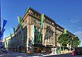
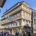
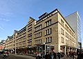
After the turn of the century, a new urban planning ideal emerged in Cologne, which followed the "big city vision". The driving force behind this new understanding of building culture was Carl Rehorst , who from 1907 until his death in 1919 was responsible for urban planning in Cologne as an alderman for the entire building administration. Rehorst sought to create space for prestigious commercial and office buildings, especially in the small-scale old town with street openings and widened streets with large curves. So he created a new east-west axis by enforcing the long-planned construction of the Deutz suspension bridge (1913–1915), and in its extension the Gürzenichstrasse was broken through and the Schildergasse widened. He continued the grand gesture that was important to him in a generous transition on Neumarkt from Schildergasse to the completely new Zeppelinstrasse, which was built on the area of former military buildings. Rehorst was able to implement his concept of architecture for the large buildings erected by different architects by implementing a uniform eaves layout and a reduced choice of materials for the designed ashlar facades. (Gürzenichstraße: Tietz department store (1912–1914), Palatium (1912); Schildergasse: Hindenburg house (1914–1915); Zeppelinstraße: Isay department store (1913–1915), Peters department store (1910–1914, today: Karstadt), Olivandenhof ( 1913), supplemented a little later by the Schwerthof (1921–1922)).

Palatium ( W. Kreis 1912)

Olivandenhof ( HE plum 1913)
Tietz department store ( W. District 1912–14)
House Hindenburg ( HE Pflaume 1914–15)
Schwerthof ( J. Koerfer 1921–22)


.jpg)

.jpg)
The breakthroughs and the bridge ramps cut deep into the medieval and baroque settlement structure. Nevertheless, the new streets are considered to be prime examples of the urban planning ideas of the time in the sense of Camillo Sitte , which would have enabled Cologne's inner city to develop into a pulsating business center. The Weltstadthaus (2005) was recently able to build on the urban vision of these streets from an architectural point of view .
Urban development in the interwar period
Green belt
After the end of the First World War, the city fathers endeavored to further develop the city, which had grown in the shape of a ring, according to the most modern knowledge of spacious, airy and green urban planning. The inner green belt offered itself as a development area, the area of which no longer had to be kept free for military purposes since 1907. The newly elected Lord Mayor Konrad Adenauer launched a competition in 1919, in which the design by Fritz Schumacher prevailed, who then received the order to develop a general settlement plan for all of Cologne. When developing it, the city planner was no longer guided by lines of flight and city parcels, but was looking for an overarching, spatial approach that was essentially conceived from the perspective of the landscape.
Schumacher (Stadtbaumeister 1920–1923) envisaged loosening up and ventilating Cologne's concentric settlement form, frozen in the rings, by means of two large semicircular green spaces - the inner and outer green belt. At the same time, these two systems should be connected by radial green wedges (such as on the Lindenthal Canal ). Adenauer succeeded in enforcing the new concept against political resistance, so that the inner green belt could be completed by 1924 with an area of 85 hectares. The outer green belt was created on the site of the former, largely demolished outer fortress belt, largely from 1927 to 1929.
Aachener Weiher with the Colonius in the background

Lindenthal Canal

University building


According to the will of the planners, the inner belt close to the city should grow together with the framing architecture to form a unit. However, of the extensive buildings planned in sonorous, somewhat bulky forms - finely graduated building blocks, buildings for science and art and a monumental train station - only the main building of the university (1929–1934) could be realized for economic reasons . In this way, a free counter-design by Paul Bonatz , published in 1920 , who wanted to see the entire green belt essentially kept free from development , was de facto realized . However, some of the green was designed to be representative, for example in the area around the Aachener Weiher . Otherwise, however, it was primarily intended to serve the leisure activities of the Cologne residents and therefore contained numerous sports, play and meadow areas. The green belt that Adenauer wanted for everyone thus became a public park, which was architecturally shaped differently and with interspersed ornaments offered the opportunity for relaxation and walks. In contrast, the outer green belt remained more open. After the war, the inner green belt received a differentiated ground relief due to the plan-integrated and greened mountains of rubble. The new building of the Museum of East Asian Art in 1977 and the Colonius telecommunications tower in 1981 set additional, but only selective, accents. Today, the inner green belt is counted as part of the significant urban inventory of Cologne, as it takes on the function of a modern, multifaceted urban park.
Fair at the Rheinpark


On the right bank of the Rhine north of Deutz, the area previously kept free for military reasons was transformed into a park landscape by 1913, which offered ideal conditions for large-scale exhibitions and trade fairs. That is why the Werkbund exhibition took place here in 1914 , which was intended to provide significant impulses for modern architecture. In order to strengthen Cologne's position as a trading center, Lord Mayor Konrad Adenauer pushed through after the First World War to build exhibition halls on the site, which were initially disparagingly referred to as Adenauer's horse stables . The Rheinhallen received its distinctive silhouette only through the representative shell development built in 1928, which city architect Adolf Abel designed on the occasion of the International Press Exhibition Pressa in a mixture of expressionist architecture and New Objectivity . The face of the Rhine, which is characteristic to this day, was effectively supplemented by the 86-meter-high trade fair tower and the State House . The extensive exhibition landscape with the postcard view of the old town enabled a highly developed exhibition site in an excellent urban planning position. The adjoining Rheinpark area was generously redesigned as a park area in the federal horticultural shows in 1957 and 1971 ; This developed into the centerpiece for the green banks of the Rhine and for the horticultural urban landscape on the Rhine .
Martinsviertel

Only one of Cologne's districts has retained an almost entirely medieval cityscape to this day, with small plots of land and narrow streets on a historically evolved city plan: the so-called Martinsviertel, which extends around the church Groß St. Martin and to the east from the banks of the Rhine and to the west from the two squares Alter Markt and Heumarkt is limited. Colloquially today it is equated with Cologne's old town, which was of course much larger; Nonetheless, the quarter received its present appearance through the renovation in the 1930s.
The Martinsviertel was completely impoverished and run down until the 20s of the 20th century and over 90% overbuilt due to the lack of space. The hygienic conditions were catastrophic. From 1927 to 1932, a fundamental renovation was planned for the area then known as the Rheinviertel, which was only implemented by the National Socialist city fathers who had ruled since 1933 - with corresponding ideological motivation. In order to create air and light, the two squares Eisenmarkt (1936) and Ostermannplatz (1937–1939) , which had been closed up until then, were recreated. In addition, the Salzgasse was widened at the intersections. The planners and preservationists received artistically valuable houses and furnishings; They also preserved the silhouette of the Rhine front with the predominantly pointed gable houses. Otherwise, around 30% of the buildings were rebuilt with the old look and feel, some of which were given a historic touch by means of historical components (wall anchors, portals). The city planners created the fictitious state of medieval Cologne under the sign of "former greatness". In its time, the renovation was considered to be the most extensive monument preservation company since the cathedral was completed and today appears as a "monument preservation".
After the severe war destruction, the reconstruction took place largely in the structures and according to the ideas of the 30s, which allowed the Martinsviertel to retain its ideally typical medieval appearance and the Cologne Rhine panorama its emblematic character.
Reconstruction after the Second World War
Cologne was a devastated city after 262 bombings at the end of the Second World War; around 80 percent of the city center was considered destroyed. In order to plan the reconstruction carefully, Rudolf Schwarz was appointed general planner from 1946 to 1952. His thoughts on the “new Cologne” are considered to be philanthropic and metaphysically based planning that wanted to depict the reconstruction with a sense of proportion and with respect for historical heritage. The general planner did not succeed in asserting himself against conflicting interests in all matters. However, he was able to preserve the traditional urban layout structure, u. a. by not leading the major roads through the center of the district, but rather as the boundaries between the Veedeln (districts). In addition, Schwarz managed to maintain a relatively high proportion of apartments within the city center and to further develop the idea of the green banks of the Rhine. In retrospect, he is certified to have generally acceptable handling of historical substance - with some sins in detail. The reconstruction after the devastating war damage changed the cityscape fundamentally: "No other large city in Germany is more shaped by the 1950s than Cologne."
Traffic axes
In the Third Reich in 1935/36 a city plan was drawn up that provided for oversized street openings in the form of axles; up to the 1940s, the east-west axis ( Hahnenstrasse ) from Rudolfplatz an den Ringen via Heumarkt to Deutz Bridge was prepared as a 68-meter-wide parade avenue with demolitions. After the war, it was possible to reduce the traffic axis to a dimension that was more compatible with the city and to build it in the area between Rudolfplatz and Neumarkt in an airy architectural form according to the plans by Wilhelm Riphahn agreed with Schwarz . Due to the traffic routing of the east-west axis over the Heumarkt, the square, which in the travel literature of the 17th century was counted among the most beautiful places in Europe, has lost its closed shape and its urban quality, which has been struggled to regain since the 1980s .
.jpg)


The north-south route has also been considered since the 1920s; the conveyor belt was built in the post-war period - to protect old streets with a slightly different route - and opened to traffic in sections from 1962 to 1966. The crossing-free expansion required complex ramps, for which the built-up areas were radically cut up. Today, the north-south drive is criticized as an oversized runway in the city that tears the old town in two.
In addition, an architectural version of the two traffic axes was only successful in a few places. For example, in 1947/48 Wilhelm Riphahn succeeded in designing the south side of Hahnenstrasse in a uniform design in the spirit of New Building and Bauhaus, in which he placed low shop pavilions in front of high residential blocks; on the north side he added the building of the British cultural institute called “Die Brücke” (1949/50). In contrast, the development of the traffic route on the brooks (from Barbarossaplatz to the Greek market to the Waidmarkt) more clearly reflects the planning intentions of Rudolf Schwarz. After that, traffic belts that are driven on by fast cars should be lined with higher point buildings, as the driving traffic gathers the distances.
Cultural center of the business city
.jpg)
.jpg)
In his high-city concept , general planner Rudolf Schwarz tried to assemble the cultural buildings in the center of the business city, both to revive the completely destroyed old town at this point, but also to create another urban space as a metropolis for Cologne. To this end, instead of the previously narrow road network, an expanded square should be created on the north-south route, which was later called Offenbachplatz as the cultural center of the business town . The cultural complex with opera house (1954–1957) and theater (1960–1962) built here by Wilhelm Riphahn was deliberately placed within the framework of a large-scale urban planning concept; the ensemble was to create a new, lively focal point within the old town. The square itself, together with the centrally located mosaic fountain, was designed by Cologne artist Jürgen Hans Grümmer (1966), who designed the floor in large white, red and dark gray colored areas. Carefully proportioned and decorated residential and commercial buildings on the edge of the square fit into the overall picture. For a long time, the square was considered to have been artificially implanted, and the 8-lane north-south drive along the square stands in the way of pedestrian-friendly integration with the city. Nevertheless, the development on Offenbachplatz is now considered one of the few successful and spacious ensembles of the new construction and a bright example of the balanced sense of shape of the urban architecture in the 1950s.
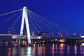
Rhine bridges
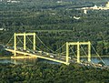
Since Cologne had become a city that lies on both banks of the Rhine due to the generous incorporations, the Rhine bridges acquired the special importance of opening up the river as the center of the city. Due to the war damage, all Cologne Rhine bridges had become unusable by March 1945; restoring them was a high priority. The newly constructed Deutz Bridge , completed in 1948 , was a steel girder bridge that was technically and inconspicuously elegant. The Cologne bridge panorama was completed by the Hohenzollern Bridge (1946–1948), Südbrücke (1946–1950), Mülheimer Brücke (1949–1951) and Rodenkirchener Brücke (1952–1954) restored to its old form , making it a model book for the History of bridge building became. The Severinsbrücke (1956–1959) projected in the traffic plan for the reconstruction and the Zoobrücke (1962–1966) built as part of the originally planned city motorway ring created important connections between the two sides of the Rhine, but they cut immeasurable aisles into the urban structure and were therefore considered an "urban structural disaster "criticized. Nonetheless, the eight bridges are certified as having an architecturally effective staging of the Cologne city panorama on both sides of the Rhine.

Hohenzollern Bridge , 1911

Mülheim Bridge , 1929
Rodenkirchen motorway bridge , 1941

Deutz Bridge , 1948
Severinsbrücke , 1959
.jpg)


_(2).jpg)

Skyscraper concept


The efforts made in the 1920s to build several high-rise buildings in Cologne that could be seen from afar had not come to fruition. It was possible to build the Hansa high- rise , after all the tallest office building in Europe in 1924, and the trade fair tower in 1926 . Nevertheless, it was not until the 1960s that Cologne received a larger number of tall houses . Senior Building Director Werner Baecker , who worked in Cologne from 1966, presented a high-rise concept in 1973. This planned to keep the old town area free of tall buildings, but to accentuate the Cologne network of ring and radial streets with visible solitary buildings and to make the modern, expanded urban landscape legible with such landmarks . In this way, urbanity was to be created through density in prominent places, for which the high-rise concept saw areas on the green belt and the Rhine as particularly suitable. In the 1960s and 1970s, around 25 high-rise buildings with a height of more than 50 meters were built, which largely corresponded to the concept. In the city context, however, the principle of order was hardly recognizable; the isolated tall buildings did not make the urban landscape more legible, but appeared to be randomly distributed. The desired effect as a compact high-rise ensemble could be achieved most likely at the high-rise residential buildings in Riehl near the Rhine (including Colonia-Haus (1973), the highest residential high-rise in Europe at the time) and at the intersection of the Luxemburger Strasse and Universitätsstrasse traffic axes on the inner green belt ( including Uni-Center (1973), Justice Center (1981)).
Reconstruction of historical buildings
The severe war destruction - with the exception of the cathedral - affected almost all traditional buildings. The buildings of Groß St. Martin and the town hall tower structuring the Cologne Rhine panorama were deeply torn ruins, the town hall itself - with the exception of the arbor - shattered in ruins and the Gürzenich destroyed up to the outer walls. Of the twelve large Romanesque churches in Cologne, 11 were badly and sometimes very badly damaged; The same applied to the towers of the city fortifications. With the creative accompaniment of the preservation department, those responsible decided to rebuild many historically significant buildings from the Middle Ages, whereby the reconstruction mostly represented a purified version of an assumed medieval ideal.

Town hall tower (reconstructed until 1995)

Groß St. Martin (rebuilt until 1985)

Bayenturm (regained 1987)

St. Mary in the Capitol (recovered by 1984)
.jpg)


The reconstruction of the buildings lasted until the 1990s: The town hall tower, which was rebuilt until 1975, only got its sculptures back between 1988 and 1995, the restoring reconstruction of Groß St. Martin was completed in 1985 and the Bayenturm , a striking tower of the City fortifications on the Rhine, was not rebuilt until 1987. Due to the reconstruction or recovery of the numerous historical buildings, the Cologne cityscape is now perceived as historically underpinned in important square and street ensembles. As a result, these traditional buildings are now once again considered to be essential identifiers for medieval Cologne, although in large parts they are also new buildings.
Opening to the Rhine

From the 1960s onwards, car traffic was gradually displaced from the city center: Schildergasse (1965) and Hohe Straße (1967), both of which are now among the most heavily frequented shopping streets in Germany, became the first sections of the pedestrian zone; architecturally, however, they are modest. However, due to its narrowness, the Hohe Straße still shows the medieval format, which goes back to the Roman main street in north-south direction. In the years that followed, the traffic-calmed area was expanded significantly and the initially very linear zones were slowly networked. At the same time, the cathedral was freed from its island location, surrounded by traffic, when the Domplatte, reserved for pedestrians , gave the area around the cathedral a new face in 1968–1970 . The Roman-Germanic Museum (1967–1974) closed the cathedral courtyard to the southeast.
In the 1980s, the city center was reopened to the Rhine. The Ludwig Museum (1980–1986) made it possible to continue the level of the Domplatte via the Heinrich-Böll-Platz, newly created by Dani Karavan from 1982–1986, to the Rheingarten, where it leads down to the Rhine via a wide staircase. The Rheingarten itself, a green space planned between the old town and the river bank according to plans by Georg Penker, became possible after the Rheinuferstraße was sunk into a tunnel in 1982. The increasingly networked pedestrian zones that extend as far as the Rhine are now considered a fine example of modern urbanity. This park-like area between the two Rhine bridges is now also rated as an exemplary urban repair, because the traffic could be banned into the tunnel and the Rheingarten was created above it as a living room in Cologne . The 500-meter-long outside staircase on the Deutz side of the Rhine, built from 2008 to 2016, changed the urban space on the Rhine again. The city grandstand, known as the Rheinboulevard , opened up a new view of the old town and staged the Rhine as the focal point of Cologne, attracting the public.
Post-industrial urban development
In recent decades, Cologne's cityscape has received significant impulses from the development of the former freight yard with the Mediapark , the development in Deutz (including the construction of the Kölnarena ) and the transformation of the Rheinauhafen into a modern, mixed city quarter.
Media park
.jpg)
The construction of the district called Mediapark on the site of the former Gereon freight station not far from the rings was considered the largest urban development project in Cologne at the end of the 20th century. In a north-westerly direction, the quarter blends in with the area of the Neustadt, which was originally planned by Josef Stübben and which the city architect had originally kept free for the new central station to be built. In the course of the conversion, the site was therefore an ideal extension of the city center beyond the Hansaring. As an innovative development project, the city wanted mainly media companies to settle here.
An international competition was announced in 1988 for the urban planning concept of this inner city location, from which the German-Canadian architect Eberhard Zeidler emerged as the winner. According to his design, individual buildings are grouped in a semicircle around a car-free square facing the city center, the size of which is consciously based on the central square of Siena . In front of this Mediaplatz is a 20,000 square meter, natural lake designed to reflect the architecture and create a recreational area close to the city. A prominent point of the development is a high-rise planned as a “ campanile ”, the 148-meter Cologne Tower , which is in the visual axes of the streets leading to the square. The aim of the system was expressly not to create an autonomous district island. The expensive and ambitious design was delayed after a hopeful start, however, when the crisis in the media industry coincided with economic difficulties in project development. The development was not completed until 2003.
The Mediapark became a functional district that was intended to anticipate the settlement and workplace structure of the 21st century. The "collage of small Manhattan, Piazza del Campo and leafy suburbs", created with a grand, postmodern gesture, honors the fact that it combines representative architecture, parkland and urban greenery in a new concept. Nevertheless, the redesigned quarter has been criticized as a drawing board that lacks real charm and well-established life.
Deutz trade and logistics center

At the turn of the millennium, extensive planning was carried out to determine how the Deutz, located opposite the historic old town, could be given its own, self-confident urban development. Starting with the newly established ICE train station Deutz and the exhibition grounds , the deliberations sought to form a trade and logistics center in Deutz, which should position itself with a number of high-rise buildings as a modernist business location. Its planning was deliberately inspired by the La Défense district in Paris .
The first important step was the Kölnarena (1996–1998), which was built according to a design by the architects' office Gottfried Böhm and , with 20,000 seats, is one of the largest multifunctional halls in Europe. The spanning, parabolic arch of the oval hall also gave the city another landmark as the “ little handle man ”. The city administration moved into the hall's outer shell, which was divided into two rows and eight cross bars. Critics, however, certified the extensive complex as "gigantomania" and doubted that the large buildings could be organically integrated into the district because of their monofunctionality.
In fact, the further development of the "trade and logistics center" was delayed: In the vicinity of the ICE train station, five high-rise buildings were planned, which should define their own skyline in the Deutz area . These towers, however, were stopped by the objection of UNESCO , which saw the sight of the cathedral impaired and therefore threatened to revoke its status as a world cultural heritage site . So far it has remained with a single new tower, the Cologne Triangle (2004–2006), which was already completed at the time of the objection , but which critics attest particularly little consideration for urban planning due to its formal dominance.
Rheinauhafen
The Rheinauhafen , which was rebuilt from 2001 to 2013, is considered the youngest "masterpiece of urban development" in Cologne. After the logistical importance of the port near the old town had continuously decreased in the course of the 1960s, the city decided to convert the area. A sophisticated, urban space with green and open spaces was to be created on the area, which extends around two kilometers on the Rhine and is built on with warehouses and silos. To this end, the city invited to an urban planning competition in 1991, as a result of which the idea proposed by the award winner Teherani to add three so-called "crane houses" to the Cologne city panorama upstream of the Rhine prevailed . The rest of the development was arranged more linearly and parallel to the Rhine, with the existing listed buildings being included in the planning.

Granary and "Siebengebirge"

New living on the Rhine promenade

Rhine panorama with crane houses
.jpg)
.jpg)
A mixed city district has emerged on the Rheinauhafen site, around 30 percent of which is used for apartments, 45 percent for offices, services and restaurants, and around 25 percent for culture. Several historical warehouses and silos, including the silhouette-defining "Siebengebirge" (1909) and the tower-like granary (1938/39) were converted for the new use in close coordination with the monument protection authorities. In contrast, the three completely newly built, around 60-meter-high crane houses were planned from the outset as a dominant, image-building group with which the Cologne city skyline should be concisely expanded. In their shape - as crane-like jibs over the river - they should also be reminiscent of the history of the port. Since all car traffic has been banned underground to one of the longest parking garages in Europe, the development also leaves space for a spacious Rhine promenade, whose design with large-format concrete slabs and Corten steel is intended to convey the raw charm of the historic port.
The successful mix of historic, listed buildings and high-quality modern architecture has been recognized on the site, which is known as the "new showcase quarter". Although the individual buildings each had their own architectural signature, the ensemble had a coordinated overall impression. The promenade also creates attractive open space for the population; however, the new district is only connected to the southern part of the city at a few points. The crane houses, however, whose long-distance effect undoubtedly complements the Cologne Rhine panorama in a modern way, have been criticized for their clumsy proportions and their less elegant facade.
Culture trail
The architect Oswald Mathias Ungers came up with the term Via Culturalis for the roughly 800-meter-long connection in Cologne's old town between the cathedral and the Romanesque church of St. Maria im Kapitol . In his opinion, the city's history of around 2000 years of Cologne can be read in this urban space, because the ruins of the Roman Stadthalter's palace and the Capitol, the historic town hall , the late medieval Gürzenich ballroom , the medieval Jewish quarter and of course the cathedral are located on this line . In the past few decades, other cultural buildings have been assembled in this urban space: the Spanish Building (1954–1956), the Roman-Germanic Museum (1974), the Philharmonie (1986), the Ludwig Museum (1986) and the Wallraf-Richartz Museum (2001). In addition, there are around a dozen places on this path, some of which, however, lack quality of stay. Critics pointed out that although the evoked path was now well described, it still appeared more as an imaginary line than a line made in the context of the city. In order to turn this cultural trail into the “calling card of a city”, the city of Cologne has started extensive construction work to redesign streets, squares and buildings. The Jewish Museum under construction on Rathausplatz and the planned new City Museum , which, with the emphatic designation Historical Center, are to redefine the southeastern transition from the Domplatte to the old town, should be highlighted. For the former WDR area between Roncalliplatz and Laurenzplatz, which has previously been considered a "blot in the city center", investors have now proposed a new development, which has been praised under the name Laurenz-Carré "as a good symbiosis between urban development and urban revitalization".
Kurt-Hackenberg-Platz (new 2018)

Günter-Wand-Platz (new until 2020)
Rathausplatz (new until 2023)

Roncalliplatz (new after 2025)


.jpg)
literature
- Cologne - his buildings 1928–1988. Bachem, Cologne 1991, ISBN 3-7616-1074-2 .
- Cologne - his buildings 2000. Bachem, Cologne 2000, ISBN 3-7616-1380-6 .
- Architecture Forum Rhineland e. V. (Ed.): Cologne city architect and the development of the city building authorities since 1821. Cologne City Museum, Cologne 2007, ISBN 978-3-940042-03-3 .
- Paul Bauwens-Adenauer, Ulrich S. Soénius: The master plan for Cologne. Albert Speer's vision for downtown Cologne. Greven, Cologne 2009, ISBN 978-3-7743-0436-9 .
- Walter Buschmann, Matthias Hennies, Alexander Kierdorf: Via Industrialis, journeys of discovery Cologne industrial culture. Klartext, Essen 2018, ISBN 978-3-8375-1873-3
- Wolfgang Till Busse: Modern Architecture in Cologne 1990-2010. Gaasterland, Cologne 2011, ISBN 978-3-935873-37-6
- Gerhard Curdes , Markus Ulrich: The development of the Cologne urban area. The influence of models and innovations on the shape of the city. Dortmund 1997, ISBN 3-929797-36-4 .
- Helmut Fußbroich, Dierk Holthausen: Architecture Guide Cologne, Profane Architecture after 1900. JPBachem, Cologne 1997, ISBN 3-7616-1305-9
- Hiltrud Kier: Reclam's city guide. Architecture and Art Cologne. Reclam, Stuttgart 2008, ISBN 978-3-15-018564-3 .
- Stefanie Lieb, Petra Sophia Zimmermann: The dynamics of the 50s, architecture and urban planning in Cologne. Michael Imhof, Petersberg 2007, ISBN 978-3-86568-295-6
- Udo Mainzer: A short illustrated architectural history of the city of Cologne. JPBachem, Cologne 2017, ISBN 978-3-7616-3108-9
- Barbara Schlei, Uta Winterhager, Tobias Groß (eds.): Architecture guide Cologne, 103 contemporary and modern buildings and quarters. Walther König, Cologne 2015, ISBN 978-3-86335-720-7
Web links
- koelnarchitektur.de The internet portal for the architectural city of Cologne
- bauwatch The architecture guide of Cologne
Individual evidence
- ^ Paul Bauwens-Adenauer, Ulrich S. Soénius: The master plan for Cologne, Alber Speer's vision for the inner city of Cologne. Cologne 2009, p. 39.
- ↑ Gerhard Curdes, Markus Ulrich: The development of the Cologne urban space, the influence of models and innovations on the shape of the city. Dortmund 1997, p. 73ff.
- ↑ The two important traffic axes of the Roman city did not cross, but were connected by the forum, which, however, can no longer be read in the cityscape. Cf. Gerhard Curdes, Markus Ulrich: The development of the Cologne urban space, the influence of models and innovations on the shape of the city. Dortmund 1997, p. 75ff.
- ↑ Gerhard Curdes, Markus Ulrich: The development of the Cologne urban space, the influence of models and innovations on the shape of the city. Dortmund 1997, p. 47ff.
- ↑ The wall followed the course of the Duffesbach in the south and can therefore still be seen today on the street of the Cologne brooks . In the east the Trankgasse and the castle wall, in the west the Gertrudenstrasse and the Clemensstrasse form the Roman city limits. In contrast, the Roman city fortifications facing the Rhine - which ran roughly on a line across Martinstrasse and Judengasse - were heavily reshaped in the Middle Ages by the settlement of areas near the Rhine after the silting up of the Roman port . Gerhard Curdes, Markus Ulrich: The development of the Cologne urban space, the influence of models and innovations on the shape of the city. Dortmund 1997, p. 75ff.
- ↑ Gerhard Curdes, Markus Ulrich: The development of the Cologne urban space, the influence of models and innovations on the shape of the city. Dortmund 1997, p. 81.
- ↑ Gerhard Curdes, Markus Ulrich: The development of the Cologne urban space, the influence of models and innovations on the shape of the city. Dortmund 1997, p. 78ff.
- ↑ Gerhard Curdes, Markus Ulrich: The development of the Cologne urban space, the influence of models and innovations on the shape of the city. Dortmund 1997, p. 19, 48f.
- ↑ Gerhard Curdes, Markus Ulrich: The development of the Cologne urban space, the influence of models and innovations on the shape of the city. Dortmund 1997, p. 83.
- ↑ Gerhard Curdes, Markus Ulrich: The development of the Cologne urban space, the influence of models and innovations on the shape of the city. Dortmund 1997, pp. 83ff, 85.
- ^ Karl Josef Bollenbeck: Urban planning based on the Paris model. (online at: koelnarchitektur.de )
- ↑ Klaus Müller: Cologne from French to Prussian rule 1794–1815. Cologne 2005, p. 107ff.
- ^ Karl Josef Bollenbeck: Urban planning based on the Paris model. (online at: koelnarchitektur.de )
- ^ Hiltrud Kier: Reclam's city guide, architecture and art Cologne. Stuttgart 2008, p. 173ff.
- ^ Hiltrud Kier: Reclam's city guide, architecture and art Cologne. Stuttgart 2008, pp. 208ff.
- ^ Hiltrud Kier: King Rhine. (online at: koelnarchitektur.de )
- ^ Hiltrud Kier: Reclam's city guide, architecture and art Cologne. Stuttgart 2008, p. 212f.
- ^ Paul Bauwens-Adenauer, Ulrich S. Soénius: The master plan for Cologne, Alber Speer's vision for the inner city of Cologne. Cologne 2009, p. 42.
- ↑ Caroline Wirtz: "That the whole area around the cathedral should have a dignified design". The Central Cathedral Building Association and the uncovering of Cologne Cathedral (1882–1902). Cologne 2008, p. 53f.
- ^ Hiltrud Kier: Reclam's city guide, architecture and art Cologne. Stuttgart 2008, p. 162ff.
- ↑ Barbara Prescht von Taboritzki: The area around the Cologne Cathedral. (online at: koelnarchitektur.de )
- ^ Wolfram Hagspiel: The development of the Cologne city building authorities (until 1945) and their contribution to building culture. In: Architektur Forum Rheinland e. V. (Ed.): Cologne city master builder and the development of the Cologne building authorities since 1821. Cologne no year, p. 55ff.
- ^ Wolfram Hagspiel: The development of the Cologne city building authorities (until 1945) and their contribution to building culture. In: Architektur Forum Rheinland e. V. (Ed.): Cologne city master builder and the development of the Cologne building authorities since 1821. Cologne undated, p. 53, p. 56.
- ^ Hiltrud Kier: Reclam's city guide, architecture and art Cologne. Stuttgart 2008, pp. 171f, 204.
- ^ Hiltrud Kier: Reclam's city guide, architecture and art Cologne. Stuttgart 2008, p. 161.
- ↑ Henriette Meynen: Light, Air, Sun. (online at: koelnarchitektur.de )
- ^ Wolfram Hagspiel , Carl-Wolfgang Schümann: Architecture between the wars. In: From Dadamax to the Green Belt, Cologne in the 1920s. Cologne 1975, p. 215ff.
- ^ Eugen Blanck : Architecture and Urban Planning of the Twenties in Cologne. In: From Dadamax to the Green Belt, Cologne in the 1920s. Cologne 1975, p. 214.
- ↑ Kurt Schönbohm: The green areas. In: Cologne - his buildings 1928–1988. Cologne 1991, p. 184.
- ^ Paul Bauwens-Adenauer, Ulrich S. Soénius: The master plan for Cologne, Alber Speer's vision for the inner city of Cologne. Cologne 2009, p. 84f.
- ↑ Gerhard Curdes, Markus Ulrich: The development of the Cologne urban space, The influence of models and innovations on the shape of the city, Dortmund 1997, p. 140
- ↑ Udo Mainzer: Small Illustrated Architectural History of the City of Cologne, Cologne 2017, p. 144
- ↑ Werner Jung: Das moderne Köln, Cologne 2012, p. 50ff
- ↑ Gerhard Curdes, Markus Ulrich: The development of the Cologne urban space, The influence of models and innovations on the shape of the city, Dortmund 1997, p. 137
- ↑ Gerhard Curdes, Markus Ulrich: The development of the Cologne urban space, the influence of models and innovations on the shape of the city, Dortmund 1997, p. 315f
- ↑ Regine Schlungbaum-Stehr: The Martin district. In: Cologne - his buildings 1928–1988. Cologne 1991, p. 85 ff
- ^ Werner Heinen: Urban planning and architecture in 1933 to 1945. In: Cologne - his buildings 1928–1988. Cologne 1991, p. 79 f
- ↑ Regine Schlungbaum-Stehr: The Martin district. In: Cologne - his buildings 1928–1988. Cologne 1991, p. 89 ff
- ^ Hiltrud Kier: Reclam's city guide, architecture and art Cologne. Stuttgart 2008, p. 183 f
- ↑ The best overview of the blackout plans for Cologne is his book “Das neue Köln. A preliminary draft ”from April 1950.
- ^ Wolfgang Pehnt: City landscapes versus high cities. (online at: koelnarchitektur.de )
- ↑ Stefanie Lieb, Petra Sophia Zimmermann: The dynamics of the 50s, architecture and urban development in Cologne. Petersberg 2007, p. 7
- ↑ Gerhard Curdes, Markus Ulrich: The development of the Cologne urban space, the influence of models and innovations on the shape of the city, Dortmund 1997, p. 224f
- ^ Paul Bauwens-Adenauer, Ulrich S. Soénius: The master plan for Cologne, Albert Speer's vision for the inner city of Cologne. Cologne 2009, p. 102ff
- ^ Hiltrud Kier: Reclam's city guide, architecture and art Cologne. Stuttgart 2008, p. 178.
- ↑ Stefanie Lieb, Petra Sophia Zimmermann: The dynamics of the 50s, architecture and urban development in Cologne, Petersberg 2007, p. 73
- ^ Wolfgang Pehnt: City landscapes versus high cities. (online at: koelnarchitektur.de )
- ^ Hiltrud Kier: Reclam's city guide, architecture and art Cologne. Stuttgart 2008, p. 185ff, p. 187ff
- ↑ Helmut Fußbroich, Dierk Holthausen: Architekturführer Köln, Profane Architektur nach 1900, Köln 1997, p. 90
- ^ Hiltrud Kier: Reclam's city guide, architecture and art Cologne. Stuttgart 2008, p. 170.
- ↑ Barbara Schlei, Uta Winterhager, Tobias Groß: Architekturführer Köln, 103 contemporary and modern buildings and quarters, Cologne 2015, No. 004
- ↑ Stefanie Lieb, Petra Sophia Zimmermann: The dynamics of the 50s, architecture and urban development in Cologne, Petersberg 2007, p. 73
- ↑ Stefanie Lieb, Petra Sophia Zimmermann: The dynamics of the 50s, architecture and urban development in Cologne, Petersberg 2007, p. 142
- ↑ Gerhard Curdes, Markus Ulrich: The development of the Cologne urban space, the influence of models and innovations on the shape of the city, Dortmund 1997, pp. 145, 148
- ^ Hiltrud Kier: Reclams City Guide, Architecture and Art Cologne, Stuttgart 2008, pp. 188f
- ↑ Rudolf Schwarz, quoted in based on Stefanie Lieb, Petra Sophia Zimmermann: The dynamics of the 50s, architecture and urban development in Cologne, Petersberg 2007, p. 13
- ↑ Werner Schäfke, Carsten Laschet: Brücken Stadt Köln, photographs from 1900 to today, Cologne 2014, p. 12f
- ↑ Werner Schäfke, Carsten Laschet: Brücken Stadt Köln, photographs from 1900 to today, Cologne 2014, p. 179ff
- ^ Udo Mainzer: Small illustrated architectural history of the city of Cologne, Cologne 2017, p. 182f
- ↑ Gerhard Curdes, Markus Ulrich: The development of the Cologne urban space, the influence of models and innovations on the shape of the city, Dortmund 1997, p. 192f
- ↑ Udo Mainzer: Small Illustrated Architectural History of the City of Cologne, Cologne 2017, p. 182, p. 189
- ↑ Felix Feldhofer: "It must be tall, every inch of it tall": Studies on Cologne high-rise buildings from the sixties and seventies, master's thesis, Art History Institute of the University of Cologne, September 2016, p. 9ff
- ↑ Felix Feldhofer: "It must be tall, every inch of it tall": Studies on Cologne high-rise buildings from the 1960s and 1970s, master's thesis, Art History Institute of the University of Cologne, September 2016, p. 11ff
- ↑ Counting according to Felix Feldhofer: "It must be tall, every inch of it tall": Studies on Cologne high-rise buildings from the sixties and seventies, master's thesis, Art History Institute of the University of Cologne, September 2016, p. 12ff
- ↑ Barbara Schlei: Higher than wide, April 15, 2002; http://www.koelnarchitektur.de/pages/de/home/aktuell/1028.htm
- ↑ Chair and Institute for Urban Development and Regional Planning RWTH Aachen: Independent expert opinion on the “Cityscape compatibility study for high-rise planning in Cologne” on behalf of the State of North Rhine-Westphalia; May 2005, p. 13.
- ↑ Felix Feldhofer: "It must be tall, every inch of it tall": Studies on Cologne high-rise buildings from the sixties and seventies, master's thesis, Art History Institute of the University of Cologne, September 2016, pp. 55ff
- ↑ Ulrich Krings: Reconstruction in the preservation of monuments - practice for exceptional cases, two Cologne examples from the time after the Second World War. In: Cologne - His Buildings 2000. p. 303.
- ↑ Ulrich Krings: Reconstruction in the preservation of monuments - practice for exceptional cases, two Cologne examples from the time after the Second World War. In: Cologne - His Buildings 2000. p. 286.
- ↑ Kurt Schönbohm: The green areas. In: Cologne - his buildings 1928–1988. Cologne 1991, p. 187.
- ↑ Ulrich Krings in: Stefanie Lieb, Petra Sophia Zimmermann: The dynamics of the 50s, architecture and urban development in Cologne, Petersberg 2007, p. 49
- ↑ German Landscape Architecture Prize
- ^ Rolf Vollmer: The MediaPark Cologne. In: Cologne - His buildings 2000. Cologne 2000, p. 117f.
- ^ Hiltrud Kier: Reclam's city guide, architecture and art Cologne. Stuttgart 2008, p. 229f.
- ^ Bernhard Stratmann: Urban development in global times. Local strategies, urban quality of life and globalization. 1999, p. 163f.
- ↑ Süddeutsche Zeitung. quoted from mediapark.de
- ^ Gerhard Curdes, Markus Ulrich: The development of the Cologne urban area. The influence of models and innovations on the shape of the city. Dortmund 1997. 324f
- ↑ Beate Hinrichs: Who does the city belong to? About the loss of public space. Deutschlandradio, December 16, 2003.
- ↑ Petra Metzger: The Deutzer "Hochhausjammer" - a review. (online at: koelnarchitektur.de )
- ^ Hiltrud Kier: Reclam's city guide, architecture and art Cologne. Stuttgart 2008, p. 248.
- ↑ Wolfram Hagspiel (ed.): Cologne - an architecture guide. Berlin 1999, p. XIX.
- ↑ Ulrich Grützner: Go over there! August 9, 2003 (online at: koelnarchitektur.de )
- ↑ Petra Metzger: The Deutzer "Hochhausjammer" - a review. (online at: koelnarchitektur.de )
- ^ Hiltrud Kier: Reclam's city guide, architecture and art Cologne. Stuttgart 2008, p. 248.
- ↑ Andreas Damm: Preserve the charm of the southern part of the city. In: Kölner Stadtanzeiger. online, March 11, 2008. (online) ( page no longer available , search in web archives ) Info: The link was automatically marked as defective. Please check the link according to the instructions and then remove this notice.
- ^ Béla Dören: History of the Rheinauhafen. In: Cologne - His buildings 2000. Cologne 2000, p. 123f.
- ↑ The concept of the Rheinauhafen. (online at: rheinauhafen-koeln.de )
- ↑ Alejandra Pérez Siller: The conversion of the Danzig warehouse. (online at: rheinische-industriekultur.de )
- ↑ Christiane Müter: Conversion of silo building in the Cologne Rheinauhafen. (online at: rheinische-industriekultur.de )
- ^ Béla Dören: History of the Rheinauhafen. In: Cologne - His Buildings 2000. Cologne 2000, p. 124.
- ↑ Christian Holl: The exception and the rule. on: german-architects.com , (online on: koelnarchitektur.de )
- ↑ Rheinauhafen attraction: Cologne has a new showcase district. on: n-tv online , April 7, 2010, (online)
- ↑ Christian Holl: The exception and the rule. (online at: koelnarchitektur.de )
- ↑ The love of the upright citizen. In: Frankfurter Allgemeine Zeitung. (online at: faz.net )
- ↑ Investors Favorite, Mittleres Kranhaus nominated for MIPIM Awards. on: koelnarchitektur.de February 3, 2009. (online)
- ↑ Cologne master plan
- ^ Via Culturalis
- ^ Breslauer Platz, Roncalliplatz, Kurt-Hackenberg-Platz, Am Hof, Theo-Burauen-Platz, Rathausplatz, Laurenzplatz, Gülich-Platz, Augustusplatz, Marsplatz, Quartermarkt, Günter-Wand-Platz, Elogiusplatz, Hermann-Josef-Platz
- ↑ Kölner Stadtanzeiger: Via culturalis: a new cultural path through Cologne city center
- ↑ Cologne architecture: density versus height
- ^ Franz-Josef Höing, councilor of the city of Cologne for urban development
- ↑ Polis Magazin: A cultural path for the cathedral city: via culturalis
- ↑ The historic center is coming (online at koelnarchitektur.de)
- ↑ Kölner Rundschau: Ideas for the Laurenz-Carré
- ↑ Cologne architecture: density versus height