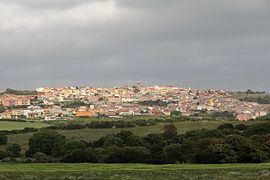
Uri (Sardinia)
| Uri | ||
|---|---|---|

|
|
|
| Country | Italy | |
| region | Sardinia | |
| province | Sassari (SS) | |
| Coordinates | 40 ° 38 ′ N , 8 ° 30 ′ E | |
| height | 150 m slm | |
| surface | 56.72 km² | |
| Residents | 2,921 (Dec. 31, 2019) | |
| Population density | 51 inhabitants / km² | |
| Post Code | 07040 | |
| prefix | 079 | |
| ISTAT number | 090076 | |
| Popular name | Uresi | |
| Patron saint | Nostra Signora della Pazienza (September 13th) | |
| Website | Uri | |

|
||
Uri is an Italian municipality ( comune ) with 2921 inhabitants (as of December 31, 2019) in the province of Sassari in Sardinia . The municipality is located about 11 kilometers southwest of Sassari . In the municipality is the reservoir Lago del Cuga (Italian: Bacino Artificiale del Cuga ).
Attractions
In the municipality there are remains of the nuragic culture from the period between 1700 and 200 BC. The Nuragic settlement of Santa Caterina is located in the municipality . The ruins of the Paulus Abbey on the parish border with Ittiri are also important .
traffic
In Uri cross in the small village of Cantoniera Scala Cavalli the State Road 131bis Carlo Felice and the State Road 127bis Settentrionale Sarda .
Web links
Commons : Uri (Sardinia) - Collection of images, videos and audio files
Individual evidence
- ↑ Statistiche demografiche ISTAT. Monthly population statistics of the Istituto Nazionale di Statistica , as of December 31 of 2019.


