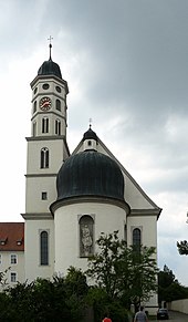
Maihingen
| coat of arms | Germany map | |
|---|---|---|

|
Coordinates: 48 ° 56 ' N , 10 ° 30' E |
|
| Basic data | ||
| State : | Bavaria | |
| Administrative region : | Swabia | |
| County : | Danube Ries | |
| Management Community : | Wallerstein | |
| Height : | 425 m above sea level NHN | |
| Area : | 14.18 km 2 | |
| Residents: | 1212 (Dec. 31, 2019) | |
| Population density : | 85 inhabitants per km 2 | |
| Postal code : | 86747 | |
| Area code : | 09087 | |
| License plate : | DON, Lower Austria | |
| Community key : | 09 7 79 176 | |
| Community structure: | 5 parts of the community | |
| Association administration address: | Weinstrasse 19 86757 Wallerstein |
|
| Website : | ||
| Mayor : | Franz Stimpfle (WG Maihingen / WG Utzwingen) | |
| Location of the municipality of Maihingen in the Donau-Ries district | ||
Maihingen is a municipality in the Swabian district of Donau-Ries and a member of the Wallerstein administrative community .
geography
Maihingen is located in the Nördlinger Ries and is part of the Augsburg planning region .
The municipality has five officially named municipal parts (the type of settlement is given in brackets ):
- Klostermühle ( wasteland )
- Langenmühle (wasteland)
- Lochmühle (wasteland)
- Maihingen ( parish village )
- Utzwingen (parish village)
There are the districts of Maihingen and Utzwingen.
history
Until the church is planted
The place was first mentioned in a document in 1251. Maihingen was owned by the monastery Zimmer and the Counts of Oettingen-Oettingen, later the Princes of Oettingen-Wallerstein and Oettingen-Spielberg and belonged to the Principality of Oettingen-Wallerstein since 1803 . With the Rhine Confederation Act 1806, the place came to the Kingdom of Bavaria .
Incorporations
On July 1, 1974, the previously independent municipality of Utzwingen was incorporated.
Population development
Between 1988 and 2018 the community grew from 1,081 to 1,191 by 110 inhabitants or 10.2%.
- 1961: 1069 inhabitants
- 1970: 1049 inhabitants
- 1987: 1043 inhabitants
- 1991: 1136 inhabitants
- 1995: 1215 inhabitants
- 2000: 1224 inhabitants
- 2005: 1241 inhabitants
- 2010: 1229 inhabitants
- 2015: 1215 inhabitants
politics
mayor
Mayor is Franz Stimpfle (Voting Group Maihingen / Voting Group Utzwingen). He was the successor to Franz Zekl (constituency of voters) in 2002 and was confirmed in office in the local elections in 2008, 2014 and 2020.
Municipal council
The municipal council has twelve members plus the mayor. After the local elections on March 15, 2020, it includes four members of the Utzwingen voter community and eight members of the Maihingen voter community; the distribution of seats between the two groups of voters is unchanged from the 2014 to 2020 term of office.
coat of arms
- Maihinger coat of arms:
 |
A continuous golden tray in red , covered with a silver shield, inside two crossed, gold-armored red bear paws. The emblem of the municipality of Maihingen is derived from the coat of arms of the Counts of Oettingen, who ruled over the municipality of Maihingen for centuries. Maihingen has always been the seat of the "Lords of Maihingen", who belonged to the Oettingen vassal nobility and were first documented in 1273. The bear paws presumably come from the coat of arms of the "Lords of Maihingen", whose shield can also be seen in the coat of arms hall of Hochaltingen Castle . |
- Utzwingen coat of arms:
Attractions
Maihingen monastery complex
The monastery Maihingen is a former Minorite . Since October 1st, 1984 it has been the seat of the Catholic Evangelism Center (KEM). Courses and seminars for renewing and deepening the faith and for employee training take place here. The KEM is supported by the Lumen Christi Community .
Monastery church
The classicist Tempietto in the entrance hall of the Maria Immaculata monastery church is particularly worth seeing . It was created by the Augsburg sculptor Ignaz Ingerl and originally stood in the park of Hohenaltheim Palace as a memorial to Maria Theresa Princess von Thurn und Taxis (1757–1776), the first wife of Prince Kraft Ernst von Oettingen-Wallerstein (1748–1802). The tomb for Count Philipp Carl von Oettingen-Wallerstein (1722–1766) is also located in the church. It was also built by Ignaz Ingerl in 1789 with a high-quality portrait medallion on a pyramid that rises on a sarcophagus. There is also a baroque organ in the church, built from 1734 to 1737 by Johann Martin Baumeister (1692–1780, Eichstätt), which has largely been preserved in its original state in terms of tuning and intonation. The organ was restored between 1988 and 1990. A holy grave from 1723, which is staggered in three levels, is built under the organ gallery.
Museum KulturLand Ries

Since 1984 the Museum KulturLand Ries (formerly Rieser Bauernmuseum Maihingen), an institution of the Swabian district, has been providing insights into the folk and everyday culture of the Nördlinger Ries . In two barrier-free buildings of a former baroque monastery complex, the museum offers a variety of insights into rural life:
An exciting journey through 300 years of everyday culture in Ries has been possible since summer 2015. The modern design with rich image material and interactive multimedia stations puts the original testimonials in the right light. The focus is on the topics of living and household, goods and advertising, clothing, childhood and medical care. Eye-catchers are a grocer and a milk shop from the 1920s, a doctor and dentist's practice and a hairdressing salon from around 1950/60. The goose Marie leads the younger visitors through the exhibition on a special children's trail.
The Ries was a breadbasket in Bavaria, which is why one of the main focuses of the museum is on farm work. The varied exhibition in the "Klosterökonomie" (built in 1783/85) spans 150 years of agriculture. In addition to the objects, historical photos, video films, productions, audio samples and models to try out convey the changes in Ries agriculture from 1800 to 1950. A small museum field is tilled with historical crops such as flax, spelled or potato varieties that have now disappeared.
Regular special exhibitions, events such as the Schnitter and Potato Festival with artisanal and rural demonstrations or folk music as well as hands-on activities for school classes and children's groups are part of the varied offer.
More Attractions
- Parish Church of the Assumption
- Parish church of St. Georg in Utzwingen
- Beautiful mountain viewpoint near Utzwingen
- An old linden tree that can be reached on foot offers a view of the Nördlinger Ries landscape .
Nature trails
- Water management educational trail
- As part of the flood clearance, village renewal and land consolidation of Maihingen carried out between 1993 and 1996, the water management nature trail along the Mauch brook was also created. The brook bed was laid out broad and curvaceous. The banks were made flat and rich in bays or steep. The natural longitudinal segmentation of the stream bed are widening, narrowing, shore bays, shore projections and occasionally deeper potholes , which give the waters a very natural appearance. The newly created footpaths in the local area make it possible to experience the flora and fauna typical of the water, which have already appeared after a short time along the developed stretch of water. The woody plantings, bank reeds and herb fringes not only integrate the Mauch into their surroundings, but also offer new habitat for the still resident curlew and many animal and plant species in the wetlands.
- "Corridor and village" educational trail
- The Mayhingen corridor and village nature trail was created by the Rieser Bauernmuseum association, the Swabian district as the sponsor of the Rieser Bauernmuseum, and the Maihingen community in a joint action in and around Maihingen in 2000. Starting at the museum, it leads through the delightful Mauchtal valley to the long mill, around the monastery mountain and back to Maihingen to the sights of the village. The meadow and village nature trail in Maihingen describes five interesting Ries rock outcrops outside the village in the geological area. Agricultural crops can be learned in the fields, fruit-growing crops in the orchards. The nature trail also leads past forests and dry grassland as well as the wetlands of the Mauchauen. In the village of Maihingen, historical and ecological ideas come into their own. The starting point with information about the nature trail is in the monastery economics area of the Rieser Bauernmuseum. The section along the Mauch is 1.6 km long, the path around the Klosterberg 1.2 km and the village nature trail itself 2.5 km long.
Architectural monuments
Economy and Infrastructure
Economy including agriculture and forestry
In 2016, according to official statistics, there were 146 employees at the place of work subject to social security contributions. There were 528 employees subject to social security contributions at the place of residence, so that the number of out-commuters in that year was 382 higher than that of in-commuters. In 2016, 15 of the residents were unemployed. In 2016 there were also 38 farms.
education
In 2017 there were two day-care centers with 73 places and 59 children, seven of them under three years of age.
Sons and daughters of Maihingen
- Joseph Haas (1879–1960), composer
- Josef Stimpfle (1916–1996), Bishop of Augsburg
- Alois Stimpfle (* 1954), Roman Catholic theologian
Web links
- Entry on the coat of arms of Maihingen in the database of the House of Bavarian History
Individual evidence
- ↑ "Data 2" sheet, Statistical Report A1200C 202041 Population of the municipalities, districts and administrative districts 1st quarter 2020 (population based on the 2011 census) ( help ).
- ^ Municipality of Maihingen in the local database of the Bavarian State Library Online . Bayerische Staatsbibliothek, accessed on September 2, 2019.
- ↑ a b c Federal Statistical Office (ed.): Historical municipality directory for the Federal Republic of Germany. Name, border and key number changes in municipalities, counties and administrative districts from May 27, 1970 to December 31, 1982 . W. Kohlhammer, Stuttgart / Mainz 1983, ISBN 3-17-003263-1 , p. 792 .
- ↑ Christiane Rossner: In focus: Holy grave backdrop in Maihingen . In: Monumente , vol. 2015, issue 2, pp. 6–7.


