
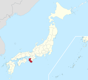
Wakayama Prefecture
|
Wakayama-ken 和 歌 山 県 |
|
|---|---|
  |
|
| Basic data | |
| Administrative headquarters : | Wakayama |
| Region : | Kinki |
| Main island : | Honshu |
| Area : | 4,724.65 km² |
| Water content: | 0.04 % |
| Residents : | 923,721 (October 1, 2019) |
| Population density : | 196 inhabitants per km² |
| Counties : | 6th |
| Municipalities : | 30th |
| ISO 3166-2 : | JP-30 |
| Governor : | Yoshinobu Nisaka |
| Website: | www.pref.wakayama.lg.jp |
| Symbols | |
| Prefecture flag : |
 |
| Prefecture tree : | Stone linden oak |
| Prefecture flower : | Ume |
| Vogel prefecture : | Japanese eyeglass bird |
| Fish prefecture : | tuna |
| Prefecture song : |
Wakayama-kenminka ("Song of the Citizens of Wakayama") Composer: Kōsaku Yamada |
The Wakayama Prefecture ( Jap. 和歌山県 , Wakayama-ken ) is a prefecture of Japan . It is located in the Kinki region on the island of Honshu . Its administrative headquarters are in Wakayama .
geography
Wakayama Prefecture is on the southwest side of the Kii Peninsula . Thus, a large part of its 600 km long coastline borders the Seto Inland Sea . To the north is Osaka Prefecture and to the northeast is Nara and Mie Prefectures . On the border of these two prefectures there are also two exclaves : a district of Shingū and the entire municipality of Kitayama , the only municipality in Japan.
As on the entire Kii Peninsula, mountains and nature determine the landscape, the larger cities are mostly on the coast. Due to the somewhat remote location, the population here is lower than in the rest of Kansai , more than a third of all residents of the prefecture live in the capital of the same name, Wakayama .
politics
The governor of Wakayama has been the former central government official Yoshinobu Nisaka since 2006 , who was most recently confirmed for a fourth term in the 2018 gubernatorial election with the support of LDP, DVP , Kōmeitō and SDP against just one communist candidate with over 80% of the votes. In parliament, which held Liberal Democratic Party in the elections in April 2019 its absolute majority.
The three constituencies Wakayamas for the lower house of the national parliament won in the last elections in 2017 unchanged Shūhei Kishimoto (Constituency 1, 4. term, Kibo no Tō , meanwhile DVP), Masatoshi Ishida (Constituency 2, 7. term, LDP) and Toshihiro Nikai (Constituency 3, 12th term, LDP); in the upper house , to which Wakayama sends one MP per election, Liberal Democrats have consistently represented the prefecture since the Liberal Democratic Party was founded in 1955, with only one temporary exception ( Yōsuke Tsuruho was elected to the Liberal Party in 1998 and only joined later).

Attractions
The prefecture is best known for its beautiful nature, especially in connection with the numerous sacred mountains and Shinto sites . The Kumano Sanzan and the mountain Kōya and its pilgrim routes are 2,004 in connection with the holy sites in Yoshino / Omine ( Nara Prefecture ) to the World Heritage Sacred Sites and Pilgrimage Routes in the Kii Mountain Range been appointed. The Yoshino-Kumano National Park , the Kongō-Ikoma-Kisen and Kōya-Ryūjin quasi-national parks , as well as the marine reserve of Kushimoto are attractions for nature and hiking enthusiasts who are looking for a little relaxation from the daily stress at work. These can also be found in the popular hot springs of Katsuura Onsen, Kawayu Onsen, Shirahama Onsen or Ryūjin Onsen.
Coastal sections worth seeing are Shirahama (the sandy beaches are also popular with the Japanese in summer), Kushimoto and Yura. The Nachi waterfall in Katsuura and the castle of Wakayama are also known.
Administrative division
In 1920 there were still 232 parishes, of which 207 were villages. As in the rest of Japan, the number of parishes in Wakayama Prefecture fell steadily (1950 = 204, 1955 = 118). In 1960 there were still 52 municipalities (38 towns belonging to a district, 7 towns and villages each). The last incorporations took place in 2006 and since then there are 9 independent towns ( Shi ), 20 small towns ( Chō ) and one village ( Mura ), the latter organized in 6 districts ( Gun ). Wakayama, seat of the prefecture administration, has also been a "core city" ( chūkakushi ) since 1997 .
In the table below, the districts ( 郡 ) are shown in italics, below each (indented) the small towns ( 町 ) and the village ( 村 ) within them. A dependency between rural district and small town can also be seen in the first three digits of the code (1st column). The independent cities are at the beginning of the table.
| code | Surname | Area (in km²) | population | Population density (inh / km²) |
||
|---|---|---|---|---|---|---|
| Rōmaji | Kanji | 01.10.2017 1 | 01.10.2018 3 | 01/10/2015 2 | ||
| 30201 | Wakayama- shi | 和 歌 山 市 | 208.84 | 357,868 | 364.154 | 1743.7 |
| 30202 | Kainan- shi | 海南 市 | 101.06 | 49,638 | 51,860 | 513.16 |
| 30203 | Hashimoto- shi | 橋 本市 | 130.55 | 61,599 | 63,621 | 487.33 |
| 30204 | Arida- shi | 有 田 市 | 36.83 | 26,937 | 28,470 | 773.01 |
| 30205 | Gobo- shi | 御 坊 市 | 43.91 | 23,681 | 24,801 | 564.81 |
| 30206 | Tanabe- shi | 田 辺 市 | 1026.91 | 71,563 | 74,770 | 72.81 |
| 30207 | Shingu- shi | 新 宮 市 | 255.23 | 27,769 | 29,331 | 114.92 |
| 30208 | Kinokawa- shi | 紀 の 川 市 | 228.21 | 59,989 | 62,616 | 274.38 |
| 30209 | Iwade- shi | 岩 出 市 | 38.51 | 53,453 | 53,452 | 1388 |
| 30300 | Kaisō-gun | 海草 郡 | 128.34 | 8,533 | 9.206 | 71.73 |
| 30304 | Kimino-cho | 紀 美 野 町 | 128.34 | 8,533 | 9.206 | 71.73 |
| 30340 | Ito-gun | 伊 都 郡 | 332.88 | 23,483 | 24,721 | 74.26 |
| 30341 | Katsuragi-cho | か つ ら ぎ 町 | 151.69 | 16,249 | 16,992 | 112.02 |
| 30343 | Kudoyama-cho | 九 度 山 町 | 44.15 | 4114 | 4377 | 99.14 |
| 30344 | Koya-cho | 高 野 町 | 137.03 | 3120 | 3352 | 24.46 |
| 30360 | Arida gun | 有 田 郡 | 437.97 | 44,167 | 45,785 | 104.54 |
| 30361 | Yuasa-chō | 湯 浅 町 | 20.79 | 11,541 | 12,200 | 586.82 |
| 30362 | Hirogawa-cho | 広 川 町 | 65.33 | 6856 | 7224 | 110.58 |
| 30366 | Aridagawa-cho | 有 田 川 町 | 351.84 | 2577 | 26361 | 74.92 |
| 30380 | Hidaka-gun | 日 高 郡 | 655.38 | 49,552 | 51,544 | 78.65 |
| 30381 | Mihama-cho | 美 浜 町 | 12.77 | 7179 | 7480 | 585.75 |
| 30382 | Hidaka-cho | 日 高 町 | 46.19 | 7641 | 7641 | 165.43 |
| 30383 | Yura-cho | 由 良 町 | 30.94 | 5432 | 5837 | 188.66 |
| 30390 | Inami-cho | 印 南 町 | 113.62 | 7748 | 8068 | 71.01 |
| 30391 | Minabe- cho | み な べ 町 | 120.28 | 12.114 | 12,742 | 105.94 |
| 30392 | Hidakagawa-cho | 日 高 川 町 | 331.59 | 9438 | 9776 | 29.48 |
| 30400 | Nishimuro gun | 西 牟 婁 郡 | 432.79 | 39,691 | 40,649 | 93.92 |
| 30401 | Shirahama-cho | 白 浜 町 | 200.98 | 20,787 | 21,533 | 107.14 |
| 30404 | Kamitonda-cho | 上 富田 町 | 57.37 | 15,080 | 14,989 | 261.27 |
| 30406 | Susami-cho | す さ み 町 | 174.45 | 3824 | 4127 | 23.66 |
| 30420 | Higashimuro gun | 東 牟 婁 郡 | 667.22 | 36,128 | 38,599 | 57.85 |
| 30421 | Nachikatsuura-chō | 那 智 勝浦 町 | 183.31 | 14,643 | 15,682 | 85.55 |
| 30422 | Taiji- cho | 太 地 町 | 5.81 | 2916 | 3087 | 531.33 |
| 30424 | Kozagawa- chō | 古 座 川 町 | 294.23 | 2640 | 2826 | 9.6 |
| 30427 | Kitayama-mura | 北 山村 | 48.20 | 426 | 446 | 9.25 |
| 30428 | Kushimoto-cho | 串 本 町 | 135.67 | 15,503 | 16,558 | 122.05 |
| Shi-bu ( All shi , part of urban districts) | 市 部 | 2070.05 | 732.497 | 753.075 | 363.8 | |
| Gun-bu ( All gun , proportion of counties) | 郡 部 | 2654.58 | 201,554 | 210.504 | 79.3 | |
| 30000 | Wakayama-ken (Wakayama Prefecture) | 和 歌 山 県 | 4724.64 | 934.051 | 963.579 | 203.95 |
swell
1 Area data from 2017
2 Results of the 2015 census
3 Estimated population 2018
Biggest places
| Census year | Residents | |||
|---|---|---|---|---|
| 2015 | 2010 | 2005 | 2000 | |
| Wakayama | 364.154 | 370.364 | 375,591 | 386,551 |
| Tanabe | 74,770 | 79.119 | 82,499 | 70,360 |
| Hashimoto | 63,621 | 66,361 | 53,929 | 55,071 |
| Kinokawa | 62,616 | 65,840 | —— | —— |
| Iwade | 53,452 | 52,882 | —— | —— |
| Kainan | 51,860 | 54,783 | 57,744 | 45.507 |
| Shingu | 29,331 | 31,498 | 33,790 | 33.133 |
| Arida | 28,470 | 30,592 | 32,143 | 33,661 |
| Gobo | 24,801 | 26,111 | 27.053 | 28,034 |
On November 1, 2005, 5 municipalities merge to form the city of Kinokawa.
On April 1, 2006, the city of Iwade , which belongs to the district, receives the status of an independent city
Population development in the prefecture
| Census year |
Total population |
male population |
female population |
Gender ratio men to 1000 women |
Area in km 2 |
Population density per km 2 |
|---|---|---|---|---|---|---|
| 1920 | 750.411 | 372.058 | 378.353 | 983 | 4732.66 | 158.6 |
| 1925 | 787.511 | 392.191 | 395.320 | 992 | 4732.66 | 166.4 |
| 1930 | 830.748 | 415.035 | 415.713 | 998 | 4723.42 | 175.9 |
| 1935 | 864.087 | 428,638 | 435,449 | 984 | 4723.48 | 182.9 |
| 1940 | 865.074 | 427.217 | 437.857 | 976 | 4723.48 | 183.1 |
| 1945 | 936.006 | 430.015 | 505.991 | 850 | 4723.48 | 198.2 |
| 1950 | 982.113 | 475,324 | 506.789 | 938 | 4732.40 | 207.5 |
| 1955 | 1,006,819 | 490.533 | 516.286 | 950 | 4714.99 | 213.5 |
| 1960 | 1.002.191 | 484.994 | 517.197 | 938 | 4714.99 | 212.6 |
| 1965 | 1,026,975 | 497.256 | 529.719 | 939 | 4716.23 | 217.8 |
| 1970 | 1,042,736 | 503.202 | 539,534 | 933 | 4718.69 | 221.0 |
| 1975 | 1,072,118 | 517,868 | 554.250 | 934 | 4722.41 | 227.0 |
| 1980 | 1,087,012 | 523.467 | 563,545 | 929 | 4723.18 | 230.1 |
| 1985 | 1,087,206 | 520.172 | 567.034 | 917 | 4724.62 | 230.1 |
| 1990 | 1,074,325 | 510.777 | 563,548 | 906 | 4722.34 | 227.5 |
| 1995 | 1,080,435 | 513.450 | 566,985 | 906 | 4724.29 | 228.7 |
| 2000 | 1,069,912 | 506,882 | 563.030 | 900 | 4725.55 | 226.4 |
| 2005 | 1,035,969 | 488.022 | 547.947 | 891 | 4726.08 | 219.2 |
| 2010 | 1,002,198 | 471.397 | 530.801 | 888 | 4726.29 | 212.1 |
| 2015 | 963.579 | 453.216 | 510.363 | 888 | 4724.69 | 204.0 |

Outline

Onsen in Nachikatsuura
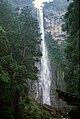
Nachi waterfall

Nachi waterfall
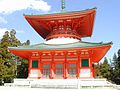
Compos Daitō ( Kōya )
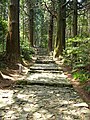
Daimonzaka pilgrimage route
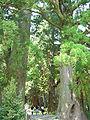
Daimonzaka pilgrimage route

Wakayama Castle


Web links
- Tourist information Kii Peninsula & Mountain Range (Japan Reference) ( Memento of July 3, 2008 in the Internet Archive )
- Tourist Information Wakayama (Japan National Tourist Organization)
Individual evidence
- ↑ 北 山村 . Kitayama, accessed September 9, 2011 (Japanese).
- ↑ Wakayama Prefectural Parliament : MPs by Group , accessed August 9, 2019.
- ↑ 和 歌 山 県 知事 選 現 職 の 仁 坂 氏 4 回 目 の 当選 . In: NHK Senkyo Web. November 26, 2018. Retrieved March 23, 2019 (Japanese).
- ↑ 統一 地方 選 2019 和 歌 山 県 議 選 各 党 議席 . In: NHK Senkyo Web. April 7, 2019. Retrieved August 9, 2019 (Japanese).
- ↑ Kokudo Chiriin (GSI - Geospatial Information Authority of Japan), 平 成 29 年 全国 都 道 府 県 市区 町 村 別 面積 調 (Nationwide survey of all prefectures and municipalities 2017) , p. 73: 30 Wakayama-ken (Japanese), accessed on 1 January 2019
- ↑ e-stat (English), accessed on January 1, 2019
- ↑ 簡 単 検 索 ・ 詳細 検 索 ・ 検 索 サ ン プ ル , accessed January 1, 2019 (Japanese)
- ↑ e-Stat database , accessed on January 1, 2019 (English)
Aichi | Akita | Aomori | Chiba | Ehime | Fukui | Fukuoka | Fukushima | Gifu | Gunma | Hiroshima | Hokkaidō | Hyōgo | Ibaraki | Ishikawa | Iwate | Kagawa | Kagoshima | Kanagawa | Kochi | Kumamoto | Kyoto | Mie | Miyagi | Miyazaki | Nagano | Nagasaki | Nara | Niigata | Ōita | Okayama | Okinawa | Osaka | Saga | Saitama | Shiga | Shimane | Shizuoka | Tochigi | Tokyo | Tokushima | Tottori | Toyama | Wakayama | Yamagata | Yamaguchi | Yamanashi
Coordinates: 34 ° 3 ' N , 135 ° 21' E