
Westerlo
| Westerlo | |||
|---|---|---|---|

|

|
||
|
|||
| State : |
|
||
| Region : | Flanders | ||
| Province : | Antwerp | ||
| District : | Turnhout | ||
| Coordinates : | 51 ° 5 ' N , 4 ° 55' E | ||
| Area : | 55.13 km² | ||
| Residents: | 25.051 (Jan. 1, 2019) | ||
| Population density: | 454 inhabitants per km² | ||
| Post Code: | 2260 | ||
| Prefix: | 014, 015, 016 | ||
| Mayor: | Guy Van Hirtum ( CD&V ) | ||
Local government address : |
Boerenkrijglaan 61 2260 Westerlo |
||
| Website: | www.westerlo.be | ||

Westerlo is a Belgian municipality in the Flanders region with 25,051 inhabitants (as of January 1, 2019).
location
The community consists of the eponymous capital and the districts Heultje , Oevel , Osterwijk , Voortkapel , Tongerlo and Zoerle-Parwijs and is located between the Grote Nete in the south and the Albert Canal in the north.
Turnhout is 24 kilometers north, Antwerp 37 kilometers northwest and Brussels about 47 kilometers southwest. The next motorway exits are in the north at Geel and Herentals on the A13 / E 313 and in the south at Halen and Aarschot on the A2 . The nearest regional train stations are in Herentals, Geel, Diest and Aarschot . The Antwerp International Airport is the nearest regional airport and Brussels National close to the capital is an airport of international importance.
history
The name Westerlo was mentioned as early as the 10th century. The history of the place is closely connected with the counts, today's princes of Merode , who still live in the castle in Westerlo today. In 1625 their rule Merode was elevated to marquisate by the Spanish king. Félix de Mérode and his brother Frédéric (1792-1830) played a role in the Belgian Revolution of 1830.
Westerlo is the home of KVC Westerlo . The club has played in the second division since the 2016/17 season .
photos
Westerlo, town hall
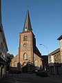
Westerlo, church

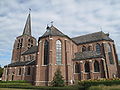
Tongerlo, church
Oevel, church

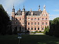
Castle de Merode


Community partnerships
- Oirschot (Netherlands)
- Ottersweier (Germany)
- Westerlo (United States)
Sons and daughters of the church
- Jo Willems (* 1970), cameraman
- Ernest Sterckx (1922–1975), racing cyclist
Web links
Aartselaar | Antwerp | Arendonk | Baarle-Hertog | Balen | Beerse | Berlaar | Boechout | Bonheiden | Boom | Bornem | Borsbeek | Brasschaat | Brecht | Dessel | Duffel | Edegem | Food | Geel | Grobbendonk | Heist-op-den-Berg | Hemiksem | Herentals | Herenthout | Herselt | Hoogstraten | Hove | Hulshout | Kalmthout | Chapels | Kasterlee | Kontich | Laakdal | Lier | Lille | Lint | Malls | Mechelen | Meerhout | Merksplas | Mole | Mortsel | Niel | Nijlen | Oils | Oud turnhout | Putte | Puurs-Sint-Amands | Ranst | Ravel | Retie | Rijkevorsel | Rumst | Clamp | Shields | Pods | Sint-Katelijne-Waver | Stabroek | Turnhout | Vorselaar | Vosselaar | Westerlo | Wijnegem | Willebroek | Wommelgem | Wuustwezel | Zandhoven | Zoersel | Zwijndrecht