Santo Antônio do Grama: Difference between revisions
Content deleted Content added
m Added website |
No edit summary |
||
| (9 intermediate revisions by 5 users not shown) | |||
| Line 1: | Line 1: | ||
{{Infobox |
{{Infobox settlement |
||
| |
| official_name = Santo Antônio do Grama |
||
| |
| native_name = |
||
| settlement_type = [[Municipalities of Brazil|Municipality]] |
|||
|image_shield = |
|||
| image_shield = File:Coat of Arms of Santo Antônio do Grama - MG - Brazil.png |
|||
| ⚫ | |||
| image_flag = File:Flag of Santo Antônio do Grama - MG - Brazil.png |
|||
|image_caption = |
|||
| ⚫ | |||
| ⚫ | |||
| |
| image_caption = |
||
| ⚫ | |||
| ⚫ | |||
| |
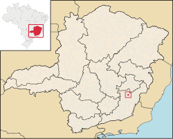
| map_caption = Location in Minas Gerais state |
||
| |
| pushpin_map = Brazil |
||
| pushpin_map_caption = Location in Brazil |
|||
| ⚫ | |||
| ⚫ | |||
| ⚫ | |||
| subdivision_type = [[List of sovereign states|Country]] |
|||
| ⚫ | |||
| |
| subdivision_name = Brazil |
||
| subdivision_type1 = [[Regions of Brazil|Region]] |
|||
| ⚫ | |||
| subdivision_name1 = [[Southeast Region, Brazil|Southeast]] |
|||
| ⚫ | |||
| subdivision_type2 = [[States of Brazil|State]] |
|||
|population_as_of = 2015 |
|||
| subdivision_name2 = [[Minas Gerais]] |
|||
| ⚫ | |||
| subdivision_type3 = [[Mesoregions of Brazil|Mesoregion]] |
|||
| ⚫ | |||
| ⚫ | |||
| ⚫ | |||
| subdivision_type4 = [[Microregion (Brazil)|Microregion]] |
|||
| ⚫ | |||
| subdivision_name4 = Ponte Nova |
|||
| ⚫ | |||
| subdivision_type5 = [[Metropolitan area#Brazil|Metrop. region]] |
|||
| subdivision_name5 = |
|||
| established_title = |
|||
| established_date = |
|||
| ⚫ | |||
| leader_title = [[Mayor]] |
|||
| ⚫ | |||
| elevation_m = |
|||
| ⚫ | |||
| ⚫ | |||
| area_metro_km2 = |
|||
| ⚫ | |||
| ⚫ | |||
| population_as_of = 2020 <ref>[https://cidades.ibge.gov.br/brasil/mg/santo-antonio-do-grama/panorama IBGE 2020]</ref> |
|||
| population_metro = |
|||
| population_density_km2 = auto |
|||
| population_demonym = |
|||
| blank_name_sec1 = [[Human Development Index|HDI]] |
|||
| blank_info_sec1 = |
|||
| timezone1 = [[Time in Brazil|BRT]] |
|||
| utc_offset1 = −3 |
|||
| timezone1_DST = |
|||
| utc_offset1_DST = |
|||
| postal_code_type = [[List of postal codes in Brazil|Postal code]] |
|||
| ⚫ | |||
| area_code_type = [[List of dialling codes in Brazil|Area code]] |
|||
| ⚫ | |||
| ⚫ | |||
}} |
}} |
||
'''Santo Antônio do Grama''' is a municipality in the state of [[Minas Gerais]] in [[Brazil]]. The population is |
'''Santo Antônio do Grama''' is a municipality in the state of [[Minas Gerais]] in [[Brazil]]. The population is 3,886 (2020 est.) in an area of 130.21 km². |
||
The city became prominent due to the [[Santo Antônio do Grama mining accident|mining accident]] in March 2018 where a mine piping from [[Anglo American plc]] leaked more than 300 tons of ore pulp to the local river, halting the [[Water supply|water supply to the population]]. <ref name="ft01">{{cite web | url =https://www.ft.com/content/70896ba0-26da-11e8-b27e-cc62a39d57a0 | title =Anglo American faces disruption in Brazil | publisher = [[Financial Times]] | author =Neil Hume | date = 2018-03-13 | access-date = 2018-03-14}}</ref> |
|||
<ref name=mj01>{{cite web | url = http://www.mining-journal.com/politics/news/1316629/brazil-investigates-anglo-pipe-leak | title =Brazil investigates Anglo pipe leak | publisher = [[The Mining Journal (trade magazine)|Mining Journal]] | date=2018-03-14 | access-date=2018-03-14}}</ref> |
|||
==References== |
==References== |
||
| Line 29: | Line 60: | ||
==External links== |
==External links== |
||
* [http://www.citybrazil.com.br/MG/stoantoniograma Santo Antônio do Grama on citybrazil.com.br] {{ |
* [http://www.citybrazil.com.br/MG/stoantoniograma Santo Antônio do Grama on citybrazil.com.br] {{in lang|pt}} |
||
* [http://www.explorevale.com.br/cidades/stoantoniograma/index.htm Santo Antônio do Grama on Explorevale] {{ |
* [http://www.explorevale.com.br/cidades/stoantoniograma/index.htm Santo Antônio do Grama on Explorevale] {{in lang|pt}} |
||
{{Municipalities of Minas Gerais}} |
|||
{{DEFAULTSORT:Santo Antonio do Grama}} |
{{DEFAULTSORT:Santo Antonio do Grama}} |
||
[[Category:Municipalities in Minas Gerais]] |
[[Category:Municipalities in Minas Gerais]] |
||
Latest revision as of 08:29, 17 January 2022
Santo Antônio do Grama | |
|---|---|
 Location in Minas Gerais state | |
| Coordinates: 20°18′50″S 42°36′32″W / 20.31389°S 42.60889°W | |
| Country | Brazil |
| Region | Southeast |
| State | Minas Gerais |
| Mesoregion | Zona da Mata |
| Microregion | Ponte Nova |
| Area | |
| • Total | 130.21 km2 (50.27 sq mi) |
| Population (2020 [1]) | |
| • Total | 3,886 |
| • Density | 30/km2 (77/sq mi) |
| Time zone | UTC−3 (BRT) |
| Website | santoantoniodograma.mg.gov.br |
Santo Antônio do Grama is a municipality in the state of Minas Gerais in Brazil. The population is 3,886 (2020 est.) in an area of 130.21 km².
The city became prominent due to the mining accident in March 2018 where a mine piping from Anglo American plc leaked more than 300 tons of ore pulp to the local river, halting the water supply to the population. [2] [3]
References[edit]
- ^ IBGE 2020
- ^ Neil Hume (2018-03-13). "Anglo American faces disruption in Brazil". Financial Times. Retrieved 2018-03-14.
- ^ "Brazil investigates Anglo pipe leak". Mining Journal. 2018-03-14. Retrieved 2018-03-14.
External links[edit]
- Santo Antônio do Grama on citybrazil.com.br (in Portuguese)
- Santo Antônio do Grama on Explorevale (in Portuguese)


