Itaguara: Difference between revisions
Content deleted Content added
m Cleaned up using AutoEd |
Tags: Mobile edit Mobile web edit |
||
| (7 intermediate revisions by 6 users not shown) | |||
| Line 1: | Line 1: | ||
{{Short description|Town and municipality in the state of Minas Gerais, Brazil}} |
|||
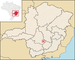
[[Image:MinasGerais Municip Itaguara.svg|thumb|right|250px|Location of Itaguara within Minas Gerais]] |
[[Image:MinasGerais Municip Itaguara.svg|thumb|right|250px|Location of Itaguara within Minas Gerais]] |
||
'''Itaguara''' is a |
'''Itaguara''' is a Brazilian municipality in the state of [[Minas Gerais]]. Its population in 2020 was 13,435.<ref>[https://cidades.ibge.gov.br/brasil/mg/itaguara/panorama IBGE 2020]</ref> |
||
== Toponym == |
|||
''Itaguara'' is a coinage from [[Tupi–Guarani languages|Tupi–Guarani]], meaning "wolf rock", by combining ''itá'' (rock) and ''guará'' (Wolf). |
|||
==See also== |
==See also== |
||
| Line 14: | Line 18: | ||
{{DEFAULTSORT:Itaguara}} |
{{DEFAULTSORT:Itaguara}} |
||
[[Category: |
[[Category:Municipalities in Minas Gerais]] |
||
{{MinasGerais-geo-stub}} |
{{MinasGerais-geo-stub}} |
||
Latest revision as of 00:11, 19 February 2023

Itaguara is a Brazilian municipality in the state of Minas Gerais. Its population in 2020 was 13,435.[1]
Toponym[edit]
Itaguara is a coinage from Tupi–Guarani, meaning "wolf rock", by combining itá (rock) and guará (Wolf).
See also[edit]
References[edit]
20°23′31″S 44°29′16″W / 20.39194°S 44.48778°W

