São João Nepomuceno
From Wikipedia, the free encyclopedia
This is the current revision of this page, as edited by 189.36.214.150 (talk) at 17:52, 18 November 2023. The present address (URL) is a permanent link to this version.
Revision as of 17:52, 18 November 2023 by 189.36.214.150 (talk)
(diff) ← Previous revision | Latest revision (diff) | Newer revision → (diff)
Municipality in the southeast of Minas Gerais, Brazil
Municipality in Southeast, Brazil
São João Nepomuceno | |
|---|---|
Municipality | |
| Nickname: SJN | |
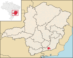
 Location in Brazil | |
| Coordinates: 21°32′24″S 43°00′39″W / 21.54000°S 43.01083°W / -21.54000; -43.01083 | |
| Country | Brazil |
| Region | Southeast |
| State | Minas Gerais |
| Incorporated | May 16, 1880 |
| Government | |
| • Mayor | Ernandes José Silva |
| Area | |
| • Total | 407,896 km2 (157,490 sq mi) |
| Population (2020 [1]) | |
| • Total | 26,447 |
| • Density | 62.6/km2 (162/sq mi) |
| Time zone | UTC−3 (BRT) |
| Website | São João Nepomuceno |
São João Nepomuceno is a municipality in the southeast of Minas Gerais, Brazil close to the state border with Rio de Janeiro.
References[edit]
21°32′S 43°00′W / 21.533°S 43.000°W / -21.533; -43.000
| International | |
|---|---|
| National | |


