
Arni AG
| AG is the abbreviation for the canton of Aargau in Switzerland and is used to avoid confusion with other entries of the name Arni . |
| Arni | |
|---|---|
 |
|
| State : |
|
| Canton : |
|
| District : | Bremgarten |
| BFS no. : | 4061 |
| Postal code : | 8905 |
| Coordinates : | 674 218 / 241317 |
| Height : | 568 m above sea level M. |
| Height range : | 510–645 m above sea level M. |
| Area : | 3.37 km² |
| Residents: | 1870 (December 31, 2019) |
| Population density : | 555 inhabitants per km² |
|
Proportion of foreigners : (residents without citizenship ) |
13.6% (December 31, 2019) |
| Website: | www.arni-ag.ch |
 Arni |
|
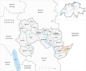
| Location of the municipality | |
  |
|
Arni (in local dialect : [ ˈɑːɾni ]) is a municipality in the Swiss canton of Aargau . It belongs to the Bremgarten district , lies on the border with the canton of Zurich and was only created in 1983 when the former municipality of Arni-Islisberg separated .
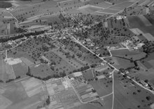
geography
The village is located a little more than three kilometers east of the Reuss , in the middle of the hollow plateau of the Holzbirrliberg . Towards the north the terrain rises gently to Seegaden ( 610 m above sea level ), towards the south to the Himmelsbüel ( 628 m above sea level ) and to Rainhau ( 594 m above sea level ). Only in the east, towards the Islisberg hill, does the terrain become steeper. The plain is drained via the Arnerbach , which flows into the Reuss at Unterlunkhofen .
The area of the municipality is 337 hectares , of which 102 hectares are covered with forest and 59 hectares are built over. The highest point is at 643 m above sea level. M. on the eastern boundary of the municipality, the deepest at 517 m above sea level. M. am Arnerbach. Neighboring communities are Aesch in the north, Islisberg in the east, Hedingen in the southeast, Jonen in the southwest, Oberlunkhofen and Unterlunkhofen in the west and Oberwil-Lieli in the northwest.
history
The oldest traces of settlement in the municipality of Arni date from the time between 800 and 500 BC. The village was part of the Kelnhof Lunkhofen, which had been donated to the St. Leodegar monastery in Lucerne in 694 and, in addition to Arni, also included Islisberg , Jonen , Oberlunkhofen and Unterlunkhofen . The place is mentioned for the first time between 1184 and 1190 in a document from Engelberg Abbey as Ârne . The name comes from an Old High German composition * ahornahi and means 'maple wood'.
In the Middle Ages there was a small castle belonging to a Kyburg - Habsburg ministerial family , of which, however, nothing has been preserved. In 1291 Rudolf I bought the Kelnhof, and the city of Lucerne and 15 other villages came into the possession of the Habsburgs for 2000 silver marks. This transaction was one of the reasons that the three original cantons founded the Old Confederation . After the Kelnhof initially belonged to the Freiamt Affoltern for administrative purposes , twenty years later it formed its own office, the so-called cellar office . In 1415 Arni was conquered by the city of Zurich . While Zurich the high jurisdiction took over, which was lower courts since 1410 owned by the city Bremgarten .
In 1529 the population of Arnis converted to the Reformed denomination, but had to return to Catholicism in 1531 after the Second Kappel War . In 1797, a year before the old rule structure collapsed, Bremgarten sold its rights to the village communities. After the conquest of Switzerland by the French and the proclamation of the Helvetic Republic in March 1798, the cellar office was dissolved and the communities of Ober- and Unterlunkhofen, Jonen, Arni and Islisberg emerged. These initially belonged to the short-lived Canton of Baden and in 1803 came to the Canton of Aargau; however, the residents initially preferred a connection to Zug or Zurich . When they joined the new canton, Arni and Islisberg were merged to form the municipality of Arni-Islisberg .
In the second half of the 20th century, Arni-Islisberg developed into a rapidly growing agglomeration community, with growth being limited to Arni. The residents of the district of Islisberg felt more and more marginalized, although they were able to decide independently on tax matters, the school system and the construction industry. In 1974 they called for the formation of an independent community in a consultative vote . The Grand Council of the Canton of Aargau initially rejected this in 1978 because there was no legal basis for it yet. In 1981 the separation was decided, which a year later was confirmed without opposition by the Grand Council and carried out on January 1, 1983. The pressure to settle in the agglomeration of Zurich led to a striking construction boom and the doubling of the population within twenty years.
Attractions

coat of arms
The blazon of the municipal coat of arms reads: "Divided by yellow with a striding red lion and by blue with a white double key." Until 1950 the then municipality of Arni-Islisberg did not have its own coat of arms. When it was introduced, historical guidelines were remembered: The red lion stands for the city of Bremgarten , which once exercised the lower jurisdiction, the key to the cellar office .
population
The population developed as follows (until 1970 including Islisberg ) :
| year | 1850 | 1900 | 1930 | 1950 | 1960 | 1970 | 1980 | 1990 | 2000 | 2010 |
| Residents | 432 | 434 | 430 | 397 | 401 | 650 | 817 | 966 | 1302 | 1741 |
On December 31, 2019, 1870 people lived in Arni, the proportion of foreigners was 13.6%. In the 2015 census, 31.9% described themselves as Roman Catholic and 28.0% as Reformed ; 40.1% were non-denominational or of other faiths. 94.8% said German as their main language in the 2000 census , 1.3% French , 0.9% Italian and 0.6% each of Albanian and English .
Politics and law
The assembly of those entitled to vote, the municipal assembly , exercises legislative power. The executing authority is the five-member municipal council . He is elected by the people in the majority procedure, his term of office is four years. The parish council leads and represents the parish. To this end, it implements the resolutions of the municipal assembly and the tasks assigned to it by the canton. The Bremgarten District Court is primarily responsible for legal disputes . Arni belongs to the Friedensrichterkreis VII (Bremgarten).
economy
According to the company structure statistics (STATENT) collected in 2015, there are around 280 jobs in Arni, 6% of them in agriculture, 25% in industry and 69% in the service sector. The majority of the working population works in the Zurich agglomeration . Thanks to its excellent location, Arni is a popular place to live for commuters . The attractive tax rate, which is one of the lowest in the canton, also contributes to this.
traffic
Kantonsstrasse 406 leads through Arni from Oberlunkhofen to Birmensdorf , where there is a junction to the A4 motorway (western bypass of Zurich ), which was opened in 2008 . In the center of the village, Kantonsstrasse 407 branches off to Hedingen . The village is connected to the public transport network with four post bus lines. These lead from Zurich-Wiedikon train station to Affoltern am Albis or Muri , from Bremgarten to Jonen and from Arni via Islisberg to Bonstetten - Wettswil train station . On weekends there is a night bus from Birmensdorf via Arni and Jonen to Obfelden .
education
The community has a kindergarten and a school house where primary school is taught. The Realschule and the secondary school can be attended in Jonen , the district school in Bremgarten . The closest grammar school is the Cantonal School in Wohlen .
Personalities
- Marc Aeschlimann (* 1995), ice hockey player
literature
- Anton Wohler: Arni (AG). In: Historical Lexicon of Switzerland .
- Peter Felder: The art monuments of the canton of Aargau . Ed .: Society for Swiss Art History . Volume IV: Bremgarten district. Birkhäuser Verlag, Basel 1967, ISBN 3-906131-07-6 .
Web links
Individual evidence
- ↑ Cantonal population statistics 2019. Department of Finance and Resources, Statistics Aargau, March 30, 2020, accessed on April 2, 2019 .
- ↑ Cantonal population statistics 2019. Department of Finance and Resources, Statistics Aargau, March 30, 2020, accessed on April 2, 2019 .
- ↑ a b Beat Zehnder: The community names of the canton of Aargau . Historical sources and linguistic interpretations. In: Historical Society of the Canton of Aargau (Ed.): Argovia . Annual journal of the Historical Society of the Canton of Aargau. tape 100 / II . Verlag Sauerländer, Aarau 1991, ISBN 3-7941-3122-3 , p. 62-64 . The phonetic transcription used : ā́rnị .
- ^ National map of Switzerland, sheet 1111, Swisstopo.
- ↑ Standard area statistics - municipalities according to 4 main areas. Federal Statistical Office , November 26, 2018, accessed on May 12, 2019 .
- ^ Joseph Galliker, Marcel Giger: Municipal coat of arms of the Canton of Aargau . Lehrmittelverlag des Kantons Aargau, book 2004, ISBN 3-906738-07-8 , p. 105 .
- ↑ Population development in the municipalities of the Canton of Aargau since 1850. (Excel) In: Eidg. Volkszählung 2000. Statistics Aargau, 2001, archived from the original on October 8, 2018 ; accessed on May 12, 2019 .
- ↑ Resident population by religious affiliation, 2015. (Excel) In: Population and Households, Community Tables 2015. Statistics Aargau, accessed on May 10, 2019 .
- ↑ Swiss Federal Census 2000: Economic resident population by main language as well as by districts and municipalities. (Excel) Statistics Aargau, archived from the original on August 10, 2018 ; accessed on May 8, 2019 .
- ↑ circles of justice of the peace. Canton of Aargau, accessed on June 20, 2019 .
- ↑ Statistics of the corporate structure (STATENT). (Excel, 157 kB) Statistics Aargau, 2016, accessed on May 8, 2019 .
Arni | Berikon | Bremgarten | Büttikon | Dottikon | Eggenwil | Fischbach-Göslikon | Hagglingen | Islisberg | Jonen | Niederwil | Oberlunkhofen | Oberwil-Lieli | Rudolfstetten-Friedlisberg | Sarmenstorf | Daily | Uezwil | Unterlunkhofen | Villmergen | Widen | Wohlen | Zufikon
Former municipality: Anglikon | Arni-Islisberg | Hermetschwil squadrons | Hilfikon | Lieli | Nesselnbach
Canton of Aargau | Districts of the Canton of Aargau | Municipalities in the Canton of Aargau