
Barendorf
| coat of arms | Germany map | |
|---|---|---|

|
Coordinates: 53 ° 13 ' N , 10 ° 31' E |
|
| Basic data | ||
| State : | Lower Saxony | |
| County : | Luneburg | |
| Joint municipality : | Ostheide | |
| Height : | 74 m above sea level NHN | |
| Area : | 9.24 km 2 | |
| Residents: | 2470 (Dec. 31, 2019) | |
| Population density : | 267 inhabitants per km 2 | |
| Postal code : | 21397 | |
| Area code : | 04137 | |
| License plate : | LG | |
| Community key : | 03 3 55 005 | |
| LOCODE : | DE ARD | |
| Address of the municipal administration: |
Schulstrasse 2 21397 Barendorf |
|
| Website : | ||
| Mayor : | Kay Benson | |
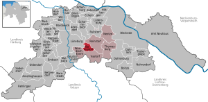
| Location of the community of Barendorf in the Lüneburg district | ||
  |
||


Barendorf is a municipality in the district of Lüneburg in Lower Saxony .
geography
Geographical location
Barendorf is on the western edge of the Elbhöhen-Drawehn nature park . Since March 1, 1974, the municipality has been the administrative seat of the integrated municipality of Ostheide with the municipalities of Barendorf, Neetze , Reinstorf , Thomasburg , Vastorf and Wendisch Evern .
landscape
The area of Barendorf is a typical Geest area . With almost two thirds, the Geest has the largest share in the landscape of Lower Saxony . It was formed in several ice ages from when glaciers with sand and gravel deposits and runoff of melt water a landscape of moraines , Sandern and glacial valleys were formed.
Barendorf does not have any natural bodies of water worth mentioning. The Elbe Lateral Canal (since 1976), which runs directly past Barendorf, connects the Port of Hamburg with the inland.
climate
Barendorf lies in the temperate zone , almost exactly between the area of influence of the maritime climate of the North Sea and the more continental inland area of the Mark Brandenburg . The statistical annual average temperature is around 9 ° C. The winters are rather mild, with occasional short continental cold spells in which temperatures below −15 ° C can be measured. The coldest months are January and February. The daytime temperature in summer tends to be around a moderate 20-25 ° C, although continental heat waves with maximum temperatures of up to 38 ° C have often been measured in recent years. The warmest month is usually July.
The average annual rainfall in the region is only around 500–600 mm. It is not uncommon for it to rain little or not at all here when there is heavy rainfall further out to sea (e.g. in Hamburg). For Barendorf itself, 643 mm are specified. The precipitation is distributed over the seasons without major differences, the maximum is in July.
There are winds from southwest to northwest. The months with the most wind are November to February. Storms occasionally occur here, which can cause damage to forests and buildings. Floods, earthquakes, volcanic activity and other natural forces are absent.
history
A settlement was found just a few kilometers from today's Barendorf, which has been proven to have been settled by the Lombards since the late Bronze Age . Later settlements can also be ascribed to the Saxons , but because of their similarity and peaceful penetration, a precise separation is neither archaeologically nor linguistically possible.
When the bypass road was built in 2006, traces of settlement from the 1st century a. Z. found. During excavation work in the western part of Barendorf, finds were made in 2015 that point to a settlement from the pre-Roman Iron Age (from the 3rd century B.C.E.). Some finds were interpreted as cooking pits / ovens, others were pits filled to the brim with stones, the purpose of which was previously unknown to archaeologists.
The fate of Barendorf, a small patch with only a few farms, has always been closely related or identical to that of Lüneburg , a city founded in 956 that became a protective castle, trading center, later Hanseatic and salt city and administrative center of the region.
Bardenthorpe itself was first mentioned in a document in 1158, but at that time it was already a village. At this time Lüneburg was already welfish. It is believed that Bar (d) endorf was named after a man (farmer) named (or by the surname) Bardo, a name that suggests that its bearer was a Longobard and not a Saxon. (According to another theory, the local name Bardi generally designates a (Lower) German as opposed to the Slavic Wends ; Barendorf lies on their long-term stable settlement border). There is a very old Indo-European word barda with the meaning 'swamp water', from which the (Lango) bards perhaps got their name because they settled in an area rich in water. Using that word as a basis, Bardenthorpe would be the place on the edge of a swampy terrain. In 1774 the area south of the village is called in Rehen / in Räin , a broken area; the newer Low German word could have replaced the old “barda”.
In the aforementioned document from 1158, Heinrich the Lion, Duke of Saxony, donated the village with all its possessions to the Bishop of Ratzeburg . Also Henry the Lion in 1172 approved the establishment of the nearby monastery Lüne . (The word Lüne , which can no longer be interpreted from today's language and which we also encounter in Lüneburg, goes back to the Old Saxon hliuni , which means 'refuge'.) In 1291 Duke Otto Barendorf bought back three truckloads of salt and sold it for the sum of 400 thalers to the Lüne monastery. Around 1300 there is talk of a Barendorpe , which is located in "Goh Modestorpe scu Oldenbrugge". (The street leading from the Lüneburg core to Barendorf is still called Altenbrückertorstraße today.)
In 1529 Barendorf became the seat of the bailiwick of the same name within the office (a new, secular administrative unit) Lüne; the Bailiwick of Barendorf administered at this time "20 villages and 2 single-ended farms, in which 153 compulsory and 16 vacant house positions were". (Geographically, the Bailiwick of Barendorf largely corresponds to the present-day municipality of Ostheide .)
For Barendorf and the neighboring villages there are reports of marauding gangs of soldiers, looting, arson and rape for 1637, 1638 and 1639; many farmers hid in the woods during these years and did not dare to go back to their farms.
Lüneburg and the surrounding area were occupied by the French in 1757-1759. Once again the peasants suffered from taxes and the eviction of soldiers, even if the extent of the suffering in the Thirty Years' War was not reached. (In 1774 the village was written in the Baroque style Bahrendorff .) Between Barendorf and Lüneburg, during the French occupation under Napoleon, the border between the French Empire and the Kingdom of Westphalia ran alongside the Lüneburg Landwehr . The Lüneburg Landwehr served as a model for the Barendorfer coat of arms in the upper area. In the lower area the six Barendofer courtyards are represented by the stars. Before the coupling there were six farms, after the estate was formed two mining sites were added, so that there were again six farms.
The oldest house in Barendorf, the later Gutsinspektorenhaus, was built in 1784.
The Barendorfer Feldmark was linked in 1828.
From the Küster, Clasen and Suhrke farms, C. von Dassel created the Barendorf estate in 1847. From 1889 the owner changed several times. From 1889 to 1910 it was Rittmeister Kommalein, whose father-in-law Johann Cornelsen had acquired it for him. It was followed in 1910 by Mr Juister, a returnee from Argentina; then 1915–1918 Oberamtmann Ungnade and August 1918 to October 1918 Captain Bachmann. On October 11, 1918, the Heinrich Bockelmann family (a grandson is Udo Jürgen Bockelmann, known as Udo Jürgens ) took over the Barendorf estate until it was divided up and liquidated. In 1953, the rural educational facility was set up on the estate in the manor house and was now run under the name Ostheide Educational and Conference Center in Barendorf. In the adjacent manor park (privately owned) you can see a Süntel beech tree and a historic bathhouse with a bathing pond.
The ev.-luth. Matthäuskirche in Barendorf, one of the four churches in the Reinstorf parish, was completed in 1965. It serves as a church center for the many new residents and newcomers as well as the locals in Barendorf.
Neu Reinstorf, also called Kivit (the former guards house on the south side of the B 216) was re-pared from the Reinstorf community to Barendorf.
Barendorf remained without structural damage in the Second World War. On April 18, 1945, an armored wedge of the British Army took Barendorf without a fight in the course of an offensive that encompassed the entire district. On May 4, 1945, an event of historical significance took place not far from Barendorf. In the tent of Field Marshal Bernard Montgomery is on the Timeloberg (80 m "Victory Hill") in Wendisch Evern the unconditional surrender of all signed in northwestern Germany the Netherlands and Denmark standing German troops.
politics
The municipality of Barendorf belongs to the state electoral district 48 Elbe and to the federal electoral district 38 Lüchow-Dannenberg - Lüneburg . In addition to the parties represented in the local council, the Barendorf Citizens' Forum is also politically active.
Municipal council
The town council from Barendorf consists of 13 council members:
- SPD : 5
- CDU : 3rd
- Citizens' Forum Barendorf : 4
- Greens : 1
As of: Local elections on September 11, 2016
mayor
The honorary mayor is Kay Benson. The deputy mayor is Jens Könke. Both were first elected on September 8, 2011 and re-elected on November 7, 2016.
traffic
The federal road 216 Lüneburg - Dannenberg (Elbe) leads directly through the community. The Elbe Lateral Canal lies on the western edge of Barendorf.
Personalities who have worked on site
- Cordt von Brandis (1888–1972), free corps leader and author of several books
- Heinrich Meyer (born December 27, 1895 - † December 19, 1974), Honorary Mayor of the Barendorf community. The appointment took place for around 50 years of voluntary work (from 1923) as community leader, village mayor, community director and first alderman in his place of birth.
literature
- Found objects. Second home book for the Lüneburg district. Lüneburg: District of Lüneburg, 1993.
- District museum of the district of Harburg: Food in the countryside. Part 1. Rosengarten: self-published, 1989.
- Helmut C Pless: Lüneburg 45th Northeast Lower Saxony between war and peace. 4. revised u. exp. Edition. Verlag der Landeszeitung, Lüneburg 1982.
- Jürgen Peter Ravens: From Bardengau to the Lüneburg district. 2. through u. exp. Edition. Nordland-Druck, Lüneburg 1985.
- Ludwig Schneider: names of places and waters in the district of Lüneburg. Lüneburg district, Lüneburg 1988.
- Samtgemeinde Ostheide (brochure). Kissing: Weka, 1993.
- Search for clues. Home register for the district of Lüneburg. Hamburg: Christians, 1990.
Web links
Individual evidence
- ↑ State Office for Statistics Lower Saxony, LSN-Online regional database, Table 12411: Update of the population, as of December 31, 2019 ( help ).
- ↑ https://de.climate-data.org/location/294021/
- ↑ http://www.landeszeitung.de/blog/lokales/265958-steingruben-haben-raetsel-auf
- ↑ Citizens' Forum Barendorf

Cities: Bleckede | Luneburg . Other communities: Adendorf | Amelinghausen | Neuhaus Office | Artlenburg | Bardowick | Barendorf | Barnstedt | Barum | Betzendorf | Boitze | Brietlingen | Dahlem | Dahlenburg | German Evern | Echem | Embsen | Handorf | Hittbergen | Hohnstorf (Elbe) | Kirchgellersen | Lüdersburg | Mechtersen | Melbeck | Nahrendorf | Networks | Oldendorf (Luhe) | Broken wheel | Rehlingen | Reinstorf | Reppenstedt | Rullstorf | Scharnebeck | Soderstorf | Südergellersen | Thomasburg | Tosterglope | Vastorf | Birds | Wendisch Evern | Westergellersen | Wittorf .