
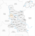
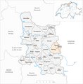
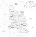
Baden District (Aargau)
| Baden district | |
|---|---|
 |
|
| Basic data | |
| Country: |
|
| Canton : |
|
| Main town : | to bathe |
| FSO number : | 1902 |
| Area : | 153.09 km² |
| Height range : | 325–859 m above sea level M. |
| Residents: | 145,198 (December 31, 2019) |
| Population density : | 948 inhabitants per km² |
| map | |
 |
|


| Seats in the Grand Council (2016-2020) |
The Baden district is a district in the canton of Aargau in Switzerland , which essentially comprises the area south of the Lägern and the lower reaches of the Limmat and Reuss rivers.
history
Historically, the Baden district developed from the medieval county of Baden , which was a joint rule of the federal estates after the conquest of the former Habsburg Aargau in 1415 and which was in 1798 after the Helvetic Revolution and the associated occupation by the French Swiss canton of Baden were incorporated. In 1803, the canton of Baden was dissolved by the mediation act and merged with the canton of Fricktal and the Swiss canton of Aargau to form the current canton of Aargau. The former county of Baden became the districts of Baden and Zurzach in the canton of Aargau.
Municipalities
The district has 26 municipalities , the largest is Wettingen . Below is the list:
| coat of arms | Name of the parish | Population (December 31, 2019) |
Area in km² |
Inhabitant per km² |
|---|---|---|---|---|
|
|
to bathe | 19,578 | 13.17 | 1487 |
|
|
Bellikon | 1554 | 4.94 | 315 |
|
|
Bergdietikon | 2833 | 5.94 | 477 |
|
|
Birmenstorf (AG) | 2986 | 7.80 | 383 |
|
|
Things of honor | 4842 | 7.29 | 664 |
|
|
Ennetbaden | 3510 | 2.11 | 1664 |
|
|
Fislisbach | 5556 | 5.05 | 1100 |
|
|
Freienwil | 1042 | 3.99 | 261 |
|
|
Gibstorf | 5460 | 5.65 | 966 |
|
|
Kill cheeks | 2058 | 2.43 | 847 |
|
|
Künten | 1789 | 4.89 | 366 |
|
|
Mägenwil | 2121 | 3.48 | 609 |
|
|
Mellingen | 5773 | 4.87 | 1185 |
|
|
Neuenhof | 8915 | 5.38 | 1657 |
|
|
Niederrohrdorf | 4135 | 3.33 | 1242 |
|
|
Oberrohrdorf | 4086 | 4.30 | 950 |
|
|
Obersiggenthal | 8637 | 8.36 | 1033 |
|
|
Remetschwil | 2023 | 3.88 | 521 |
|
|
Spreitenbach | 12,087 | 8.60 | 1405 |
|
|
Stetten (AG) | 2206 | 4.41 | 500 |
|
|
Turgi | 3000 | 1.55 | 1935 |
|
|
Untersiggenthal | 7186 | 8.28 | 868 |
|
|
Wettingen | 20,960 | 10.60 | 1977 |
|
|
Wohlenschwil | 1598 | 4.39 | 364 |
|
|
Würenlingen | 4765 | 9.37 | 509 |
|
|
Würenlos | 6498 | 9.03 | 720 |
| Total (26) | 145,198 | 153.09 | 948 | |
Fahr Monastery
The Fahr Priory, which was not assigned to any political municipality until 2007, is an Aargau exclave in the Limmat Valley in Zurich. Since 2008 the area belongs to the territory of the Aargau municipality Würenlos . In 1889 Würenlos first tried to incorporate the 1.48 hectare monastery property.
Changes in the community

Parishes until 1853
Municipalities until 1882
Municipalities until 1899
Municipalities until 1905

Municipalities until 1961

Municipalities until 2005


- 1803: Fusion of Bellikon and Hausen → Bellikon
- 1803: Split from Dietikon (in the canton of Zurich) → Bergdietikon (in the canton of Aargau) and Dietikon (in the canton of Zurich)
- 1805: Fusion Busslingen , Niederrohrdorf , Oberrohrdorf , Remetschwil and Staretschwil → Rohrdorf
- 1819: Split from Baden → Ennetbaden
- 1825: Separation of Ehrendingen → Oberehrendingen and Unterehrendingen
- 1854: Split from Rohrdorf → Niederrohrdorf , Oberrohrdorf and Remetschwil
- 1883: Separation from Gibstorf → Turgi
- 1900: Merger of Kempfhof , Oetlikon and Würenlos → Würenlos
- 1906: Fusion of Büblikon and Wohlenschwil → Wohlenschwil
- 1962: Merger of Baden and Dättwil → Baden
- 1972: Künten and Sulz → Künten merged
- 2006: Merger of Oberehrendingen and Unterehrendingen → Ehrendingen
Localities
Web links
Individual evidence
- ↑ Cantonal population statistics 2019. Department of Finance and Resources, Statistics Aargau, March 30, 2020, accessed on April 2, 2019 .
- ↑ Results of the Grand Council elections 2016. State Chancellery of the Canton of Aargau, accessed on July 27, 2020 .
- ↑ Federal Statistical Office Generalized Limits 2020.
Bathing | Bellikon | Bergdietikon | Birmenstorf | Things of honor | Ennetbaden | Fislisbach | Freienwil * | Gibstorf | Killwangen | Künten | Mägenwil | Mellingen | Neuenhof | Niederrohrdorf | Oberrohrdorf | Obersiggenthal | Remetschwil | Spreitenbach | Stetten | Turgi | Untersiggenthal | Wettingen | Wohlenschwil | Würenlingen | Würenlos
* This municipality does not own any objects of the categories A or B, but can have (currently undocumented) C objects.