
Ottenhöfen in the Black Forest
| coat of arms | Germany map | |
|---|---|---|

|
Coordinates: 48 ° 34 ' N , 8 ° 9' E |
|
| Basic data | ||
| State : | Baden-Württemberg | |
| Administrative region : | Freiburg | |
| County : | Ortenau district | |
| Height : | 327 m above sea level NHN | |
| Area : | 25.26 km 2 | |
| Residents: | 3179 (Dec. 31, 2018) | |
| Population density : | 126 inhabitants per km 2 | |
| Postal code : | 77883 | |
| Area code : | 07842 | |
| License plate : | OG, BH , KEL, LR, WOL | |
| Community key : | 08 3 17 102 | |
| LOCODE : | DE 77Q | |
| Community structure: | 2 districts | |
| Address of the municipal administration: |
Forstweg 1 77883 Ottenhöfen in the Black Forest |
|
| Website : | ||
| Mayor : | Hans-Jürgen Decker | |
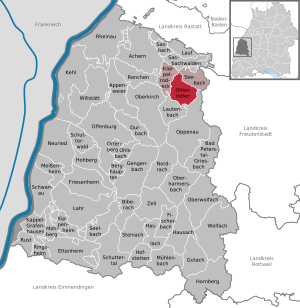
| Location of the community Ottenhöfen in the Black Forest in the Ortenau district | ||
  |
||

Ottenhöfen is a municipality and a recognized climatic health resort in the Ortenau district in Baden-Württemberg .
geography
Geographical location
The ten-valley village Ottenhöfen in the Black Forest is located in the Achertal between the Black Forest High Road and Badischer Weinstraße , 35 kilometers from Strasbourg / Alsace , Baden-Baden and Freudenstadt . The municipality extends to a height of 300 to 1005 meters and is more than 50 percent forested.
Neighboring communities
The community borders in the east on Seebach , in the south on the city of Oppenau and Lautenbach and in the west on Kappelrodeck .
Community structure
The municipality of Ottenhöfen in the Black Forest with the formerly independent municipality of Furschenbach includes numerous hamlets and so-called Zinken (farms and houses). The hamlets of Am Bach, Buchwald and Muttert, the farms of Am Rain, Günsberg (in official maps: Grünsberg) and Sommereck and Schroffen belong to the former community of Furschenbach, which was incorporated in 1973.
The municipality of Ottenhöfen includes the core town of Ottenhöfen in the Black Forest, the hamlets of Hagenbruck and In den Höfen (both structurally connected to Ottenhöfen), the Zinken Blöchereck, Dickeich, Gottschläg, Heidenbach, Kohlstatt, Langeck, the Blaubronn, Lauenbach, Roos farms (on official maps : Ross), Schloßhof, Simmersbach, Sohlberg (partly to Lautenbach), Unterwasser, Wolfersbach and Zieselberg, the residential areas Atzelbach, Brach, Bromberg, Edelfrauengrab, Holderbrünnele and Schlitz and the place Hubersloch (today's street name Bromberg). The hamlets of Kriesehof and Atzelbach are located in the Unterwasser district.
history

Local history
The Otto Hof , which gives it its name, was first mentioned in 1479. But it was not until 1817 that the settlement there became a separate community.
The area belonged to the secular territory of the prince-bishops of Strasbourg since 1316. In addition to other landowners, the knights of Bosenstein were of particular importance, but they had to sell their property at the beginning of the 15th century for financial reasons. In 1795 their territory finally came to the diocese of Strasbourg . But as early as 1803 Ottenhöfen fell to the later Grand Duchy of Baden due to the secularization due to the Reichsdeputationshauptschluss . There it initially belonged to the Achern district and from 1924 to the Bühl district , which was partially merged in 1973 in the newly formed Ortenau district. In 1898 Ottenhöfen received a railway connection.

Incorporations
On January 1, 1973, the community Furschenbach was incorporated.
Religions
Although the Reformation passed the area of today's Ottenhöfen , the place received its first Roman Catholic church only in 1823 . In the previous centuries, today's parish was initially part of the parish of Oberachern and, since 1447, it has belonged to Kappelrodeck or the parish in Waldulm . In 1823 the parish of Ottenhöfen was founded. Due to the influx of Protestants and the increasing number of spa guests, a Protestant church was also consecrated in 1936 .
politics
Administrative association
The community belongs together with Seebach to the community administration association Kappelrodeck; he is only responsible for the joint land-use planning (zoning plan). As a voluntary task, the municipalities of Seebach, Ottenhöfen in the Black Forest and Kappelrodeck have taken on the task of disposing of their wastewater via a joint sewage treatment plant in Kappelrodeck.
Municipal council
The municipal council in Ottenhöfen in the Black Forest has 14 members. The municipal council consists of the elected voluntary councilors and the mayor as chairman. The mayor is entitled to vote in the municipal council. The local elections on May 29, 2019 led to the following preliminary final result. The turnout was 63.5% (2014: 58.0%).
- CDU : 49.5 percent, 7 seats, (2014: 49.5%, 7 seats)
- FWG : 51.6 percent, 7 seats, (2014: 50.5%, 7 seats)
mayor
- 1817–1823: Joseph Blust
- 1824–1830: Anton Schneider
- 1830–1832: Joseph Hasenfratz
- 1832–1839: Sebastian Bürck
- 1839–1842: Franz Xaver Jülg
- 1842–1849: Sebastian Bürck
- 1849–1851: Johann Georg Bühler
- 1851–1870: Franz Xaver Köninger
- 1870–1874: Bernhard Bürck
- 1874–1892: Franz Xaver Rösch
- 1892–1920: Josef Baßler
- 1920–1933: Wilhelm Bohnert
- 1933-1945: Wilhelm Roth
- 1945–1946: Wilhelm Bohnert
- 1946–1958: Andreas Kimmig
- 1958–1980: Johann Käshammer
- 1980–2011: Dieter Klotz
- 2011 until today: Hans-Jürgen Decker
Mayor of the former community of Furschenbach
- 1817–1819: Joseph Schneider
- 1819–1830: Franz Xaver Blust
- 1831–1837: Joseph Heitzmann
- 1837–1843: Andreas Schneider
- 1844–1846: Joseph Baßler
- 1847-1859: Anton Faist
- 1859–1871: Nikolaus Bohnert
- 1871–1877: Johann Georg Roth
- 1877–1886: Bernhard Roth
- 1887–1893: Josef Brother
- 1893–1917: Bernhard Roth
- 1919–1920: Josef Roth
- 1921–1933: Friedrich Hund
- 1936–1940: Josef Schneider
- 1945–1946: Rudolf Schmälzle
- 1946–1948: Andreas Herrmann
- 1948–1957: Josef Roth
- 1957–1972: Franz Schneider
coat of arms
It shows an eight-spoke gold wheel in a red heraldic shield. Some want to see a mill wheel in the wheel, which is supposed to point to the former Bosenstein mill yard, but this cannot be proven. Others see the eight side valleys radiating out from the town in the coat of arms.
Culture and sights

You can hike the Mühlenweg around Ottenhöfen. It leads past several historic mills that are still in operation. Ottenhöfen therefore has the addition of Mühlendorf to the name.
To the east of Ottenhöfen is the Karlsruher Grat , over which the only via ferrata in the Northern Black Forest leads.
Museums
A museum railway operated on the Achertal Railway from Achern to Ottenhöfen in the Black Forest until 2013 . In mid-2014 the permanent cessation of operations became known. In the community center (near the train station) there is a museum on the upper floor, which shows some interesting objects from different centuries of community history.
Buildings
The Catholic parish church of St. Anna & St. Bernhard von Baden is a modern building from 1962.
There are no visible remains of the wall of the former Bosenstein Castle, which was decisive for the settlement in the valley. It is assumed that foundation walls can still be exposed in deeper areas below the surface of the earth. The site is not open to the public and is privately owned.
Regular events
In addition to numerous club events, the village fountain festival with spa garden lighting has traditionally been held on the last weekend in July for decades .
Economy and Infrastructure
The local companies have joined forces with companies from the neighboring municipality of Seebach in the “Gewerbeverein Ottenhöfen - Seebach e. V. “merged.
traffic
In 1898 the Achertal Railway to Achern was completed, the prerequisite for the transport of stone, wood and other goods from the Achertal to the Rhine Valley Railway. Today the route is operated by the Ortenau S-Bahn (OSB).
Established businesses
In addition to numerous medium-sized companies, mainly in the craft sector, there are the following larger companies: Huber-Bau GmbH & Co KG; Achertal Clinic for Psychiatry and Psychotherapy; Horn Otto GmbH construction company.
Educational institutions
With the Erwin-Schweizer-Schule there is a primary and secondary school with a technical secondary school in Ottenhöfen . The Werkrealschule was set up in the 2010/2011 school year together with the neighboring community of Kappelrodeck . There is also a kindergarten in Ottenhöfen and one in the Furschenbach district, which take in children from the age of two.
Judiciary
Ottenhöfen belongs to the district of the Achern District Court .
Leisure and sports facilities
- There is an artificial turf field for soccer.
- The Black Forest Hall is multifunctional and can be used for sports; the focus is on handball.
- Mountainbiking-Arena Achertal, signposted via the Black Forest Middle-North Nature Park.
Web links
Individual evidence
- ↑ State Statistical Office Baden-Württemberg - Population by nationality and gender on December 31, 2018 (CSV file) ( help on this ).
- ↑ State Statistical Office Baden-Württemberg, Stuttgart, 2019
- ↑ Gerhard Schindler: An end in the Achertal was in sight. (No longer available online.) In: Achertäler Eisenbahnverein. June 19, 2014, archived from the original on October 26, 2014 ; Retrieved October 26, 2014 . Info: The archive link was inserted automatically and has not yet been checked. Please check the original and archive link according to the instructions and then remove this notice.

Achern | Appenweier | Bad Peterstal-Griesbach | Berghaupten | Biberach | Durbach | Ettenheim | Fischerbach | Friesenheim | Gengenbach | Gutach (Black Forest Railway) | Haslach im Kinzigtal | Hausach | Hofstetten | Hohberg | Hornberg | Kappel-Grafenhausen | Kappelrodeck | Throat | Kippenheim | Lahr / Black Forest | Run | Lautenbach | Mahlberg | Meißenheim | Mühlenbach | Neuried | Nordrach | Oberharmersbach | Oberkirch | Oberwolfach | Offenburg | Ohlsbach | Oppenau | Ortenberg | Ottenhöfen in the Black Forest | Renchen | Rheinau | Ringsheim | Rust | Sasbach | Sasbachwalden | Schuttertal | Schutterwald | Schwanau | Seebach | Seelbach | Steinach | Willstätt | Wolfach | Zell am Harmersbach
Rheinau (municipality-free area)