Kal (Węgorzewo)
| Cal | ||
|---|---|---|

|
|
|
| Basic data | ||
| State : | Poland | |
| Voivodeship : | Warmia-Masuria | |
| Powiat : | Węgorzewo | |
| Gmina : | Węgorzewo | |
| Geographic location : | 54 ° 11 ' N , 21 ° 44' E | |
| Height : | 150 m npm | |
| Residents : | 150 (2006) | |
| Postal code : | 11-600 | |
| Telephone code : | (+48) 87 | |
| License plate : | NWE | |
| Economy and Transport | ||
| Street : | Węgorzewo → Cal | |
| Rail route : | no rail connection | |
| Next international airport : | Danzig | |
Kal ( German Kehlen ) is a village in the Polish Warmian-Masurian Voivodeship , which belongs to the urban and rural municipality Węgorzewo (Angerburg) in the powiat Węgorzewski ( Angerburg district ).
Geographical location
Kal is located in the northeast of the Warmia and Mazury at the Kehl's Bay ( Polish Zatoka Kalska ) on the west bank of the Schwenzaitsees (Polish Jezioro Święcajty) on the peninsula throats (Polish Półwysep Kalski) that here in the Schwenzaitsee, in the Mauersee (Jezioro Mamry) and reaches into Lake Bodma (Jezioro Bodma). The district town of Węgorzewo (Angerburg) is four kilometers further north.
history
The village called Kaehl and also Kähl at the time was founded in 1478. After 1785 it was also called Kehl , until the name Kehlen , which was used until 1945 , became established.
Today, located on a peninsula and only accessible from the north, the residents of Kehlen were able to get dry feet over the area of the later island of Upalten (Wyspa Upałty) and through Pristonia (1938 to 1945 ) before the damming of the Wall Lake ( Jezioro Mamry in Polish ) in the 16th century Passdorf, Polish Przystań) go to church in Engelstein (Węgielsztyn). Kehlen could also be reached on foot from today's riverside village of Kittlitz (Kietlice).
The rural community of throats was on May 6, 1874 Office and village its name to an administrative district that existed until 1945 and for district Angerburg in Administrative district Gumbinnen the Prussian province of East Prussia belonged. Integrated into the rural community of Kehlen were the localities and residential areas, covering works Angerburg, Angerburger Wasserwerk, Erlau, Waldhaus Jägerhöhe, Karlshöh (Polish: Sobin), Kehlerwald (Kalskie Nowiny), Kehlerwiese (Kalskie Łąki), Seeheim (until 1929: Thörichthof) and Seewert. On January 1, 1929, the Mauersee manor was incorporated into Kehlen.
In 1910 there were 556 inhabitants registered in Kehlen. Their number was already 601 in 1925, rose to 739 by 1933 and finally amounted to 777 in 1939.
As a result of the war, Kehlen was transferred to Poland with all of southern East Prussia in 1945 . Today the village is the seat of a Schulzenamt ( Polish Sołectwo ) and is included in the network of the urban and rural municipality Węgorzewo in the powiat Węgorzewski , before 1998 the Suwałki Voivodeship , since then it belongs to the Warmia-Masurian Voivodeship .
District of Kehlen (1874–1945)
When it was established, the district of Kehlen consisted of two, in the end just one municipality:
| Surname | Polish name | Remarks |
|---|---|---|
| Throats | Cal | |
| Angerburg, manor district | Węgorzewko | In the township in 1928 Angerburg incorporated |
| from 1929: Mauersee, manor district |
1929 incorporated into the rural community of Kehlen |
Religions
Before 1945 Kehlen belonged ecclesiastically to Angerburg ( Polish Węgorzewo ) and was in the Protestant parish church Angerburg in the parish of Angerburg in the church province of East Prussia of the Church of the Old Prussian Union and in the Catholic Church of the Good Shepherd in the deanery Masuria II (seat: Johannisburg , Polish Pisz ) parish in the then diocese of Warmia .
Today Kal belongs to the Catholic Church of St. Peter and Paul in Węgorzewo in the Deanery Węgorzewo in the Diocese of Ełk (Lyck) of the Roman Catholic Church in Poland and to the Protestant parish in Węgorzewo, a branch parish of Giżycko (Lötzen) in the Diocese of Masuria the Evangelical Augsburg Church in Poland .
"Kehlsche Mauer"
Halfway from Węgorzewo to Kal is the former Evangelical cemetery of Kehlen ( Polish: Kal cmentarz ewangelicki ). Only a few graves are recognizable or even exist at all.
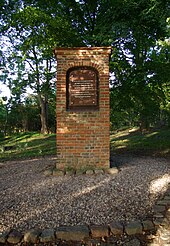
In the cemetery there is a brick pillar , two meters by two meters in plan, four meters high, which has made a name for itself as the so-called "Kehlsche Mauer" ( Kalska Kolumna in Polish ), even with the Prussian Crown Prince Friedrich Wilhelm , who saw it in 1809 sketched in his diary.
The Kehlsche Mauer was associated with the name of the Mauersee (Jezioro Mamry), others saw it as an atonement in the memory of two young couples who committed fornication at this point and were struck by lightning. We know for sure that the wall was built before 1573. On May 18, 2007, four panels were unveiled on the pillar, each in Latin, Polish, Lithuanian and German, describing an event from 1564.
Web links
Individual evidence
- ↑ Polish Postal Code Directory 2013, p. 412
- ^ Dietrich Lange, Geographical Location Register East Prussia (2005): Kehlen
- ↑ a b Kal - throats
- ↑ a b Rolf Jehke, Kehlen District
- ^ Uli Schubert, community directory, district of Angerburg
- ↑ Michael Rademacher: German administrative history from the unification of the empire in 1871 to the reunification in 1990. The district of Angerburg (Polish Wegorzewo). (Online material for the dissertation, Osnabrück 2006).
- ↑ Walther Hubatsch : History of the Protestant Church in East Prussia. Volume 3: Documents. Göttingen 1968, p. 476
- ^ City history of Angerburg


