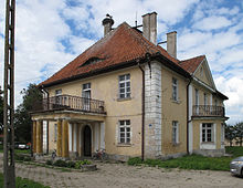
Dąbrówka Mała (Węgorzewo)
| Dąbrówka Mała | ||
|---|---|---|

|
|
|
| Basic data | ||
| State : | Poland | |
| Voivodeship : | Warmia-Masuria | |
| Powiat : | Węgorzewo | |
| Gmina : | Węgorzewo | |
| Geographic location : | 54 ° 16 ' N , 21 ° 37' E | |
| Residents : | 180 (2006) | |
| Postal code : | 11-600 | |
| Telephone code : | (+48) 87 | |
| License plate : | NWE | |
| Economy and Transport | ||
| Street : | Prynowo ( DK 63 ) - Brzozowo ↔ Guja - Bajory Małe - Brzeźnica | |
| Przystań ( ext. 650 ) - Węgielsztyn ↔ Perły | ||
| Rail route : | no rail connection | |
| Next international airport : | Danzig | |
Dąbrówka Mała ( German Klein Dombrowken , 1938-1945 Dammfelde ) is a place in the Polish Warmian-Masurian Voivodeship , which belongs to the urban and rural municipality Węgorzewo (Angerburg) in the powiat Węgorzewski ( Angerburg district ).
Geographical location
Dąbrówka Mała is located north of the Rehsauer See ( Jezioro Rydzówka in Polish ) in the northeast of the Warmian-Masurian Voivodeship , nine kilometers northwest of the district town of Węgorzewo (Angerburg) .
history
Today's Dąbrówka Mała was founded in 1482 as Damerau . In the period that followed, it bore names such as Klein Dombrowcken (around 1552), Dombrowken (before 1818) and Klein Dombrowken (until 1938). The manor village came in 1874 as a manor district to the district of Guja in the district of Angerburg in the administrative district of Gumbinnen in the Prussian province of East Prussia . In 1910 Klein Dombrowken had 102 inhabitants.
On September 30, 1928, the village gave up its independence and merged with Klein Guja (no longer existent) and Groß Guja ( Polish Guja ) to form the new rural community Groß Guja . On June 3 (officially July 16) 1938, Klein Dombrowken was renamed Dammfelde .
In 1945 came the southern East Prussia , and with it also the dam field in consequence of the war to Poland and received the Polish name form Dąbrówka Mała . Today the village is part of the urban and rural municipality Węgorzewo in the powiat Węgorzewski , until 1998 the Suwałki Voivodeship , since then the Warmian-Masurian Voivodeship .
Religions
Before 1945, Klein Dombrowken was parish in the Evangelical Church of Engelstein in the church province of East Prussia of the Evangelical Church of the Old Prussian Union and in the Catholic Angerburg Church of the Good Shepherd in the Diocese of Warmia .
Today Dąbrówka Mała belongs to the Catholic parish of St. Josef in Węgielsztyn in the Diocese of Ełk (Lyck) of the Roman Catholic Church in Poland and to the Protestant parish in Węgorzewo, a branch of the parish in Giżycko (Lötzen) in the Diocese of Masuria of the Evangelical Augsburg Church in Poland .
traffic
Dąbrówka Mała is at the intersection of two side streets, the one from Prynowo (Prinowen , 1938–1945 Primsdorf) and the state road DK 63 (former German Reichsstrasse 131 ) via Brzozowo (Brosowen , 1938–1945 Hartenstein) to Bajory Małe (Klein Bajohren , 1938–1945 Kleinblankenfelde) and on to Brzeźnica (Birkenfeld) on the Polish-Russian border or from Przystań (Prinowen , 1938–1945 Primsdorf) and the Voivodship Road 650 via Węgielsztyn (Engelstein) to Perły (Perlswalde) . There is no train connection.
Web links
Individual evidence
- ↑ Polish Postal Code Directory 2013, p. 218
- ↑ Dietrich Lange: Geographical Location Register East Prussia (2005): Dammfelde
- ^ Rolf Jehke: District Guja
- ^ Uli Schubert: Community directory, district of Angerburg
- ↑ Walther Hubatsch : History of the Protestant Church in East Prussia. Volume 3: Documents. Göttingen 1968, p. 476.


