
Canton of Albestroff
| Former Canton Albestroff |
|
|---|---|
| region | Lorraine |
| Department | Moselle |
| Arrondissement | Château-Salins |
| main place | Albestroff |
| Dissolution date | March 29, 2015 |
| Residents | 6,673 (Jan 1, 2012) |
| Population density | 33 inhabitants / km² |
| surface | 200.90 km² |
| Communities | 26th |
| INSEE code | 5701 |
The former French canton of Albestroff was in the arrondissement of Château-Salins in the Moselle department in the Lorraine region ; its main town was Albestroff .
location
The canton was in the southern half of the Moselle department.

Location of the canton of Albestroff within the arrondissement of Château-Salins
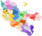
Location of the canton of Albestroff within the Moselle department


history
The canton was established in 1790 and until 1871 belonged to the Meurthe department in France. With the Treaty of Frankfurt after the Franco-Prussian War he came to the German Empire . It was named Canton Albesdorf from 1871 to 1918 and belonged to the Château-Salins district in the Lorraine district in the realm of Alsace-Lorraine . In 1918 the area returned to France and became part of the new Moselle department (identical to the German district of Lorraine). When the cantons in France changed, the canton was dissolved in 2015. All of his parishes moved to the new canton of Le Saulnois .
Communities
The canton comprised 26 municipalities:
| local community | Population year | Area km² | Population density | Code INSEE | Post Code |
|---|---|---|---|---|---|
| Albestroff | 633 (2013) | 19.30 | 33 inhabitants / km² | 57011 | 57670 |
| Bénestroff | 544 (2013) | 9.56 | 57 inhabitants / km² | 57060 | 57670 |
| Bermering | 247 (2013) | 5.73 | 43 inhabitants / km² | 57065 | 57340 |
| Francaltroff | 743 (2013) | 12.46 | 60 inhabitants / km² | 57232 | 57670 |
| Givrycourt | 96 (2013) | 2.77 | 35 inhabitants / km² | 57248 | 57670 |
| Guinzeling | 71 (2013) | 4.83 | 15 inhabitants / km² | 57278 | 57670 |
| Honskirch | 224 (2013) | 6.55 | 34 inhabitants / km² | 57335 | 57670 |
| Insming | 618 (2013) | 7.21 | 86 inhabitants / km² | 57346 | 57670 |
| Insviller | 203 (2013) | 8.34 | 24 inhabitants / km² | 57347 | 57670 |
| Léning | 300 (2013) | 6.49 | 46 inhabitants / km² | 57394 | 57670 |
| Lhor | 134 (2013) | 5.40 | 25 inhabitants / km² | 57410 | 57670 |
| Lostroff | 69 (2013) | 4.96 | 14 inhabitants / km² | 57417 | 57670 |
| Loudrefing | 320 (2013) | 23.00 | 14 inhabitants / km² | 57418 | 57670 |
| Marimont-lès-Bénestroff | 43 (2013) | 3.99 | 11 inhabitants / km² | 57446 | 57670 |
| Molring | 8 (2013) | 3.26 | 2 inhabitants / km² | 57470 | 57670 |
| Montdidier | 72 (2013) | 1.93 | 37 inhabitants / km² | 57478 | 57670 |
| Muenster | 240 (2013) | 6.60 | 36 inhabitants / km² | 57494 | 57670 |
| Nébing | 365 (2013) | 7.36 | 50 inhabitants / km² | 57496 | 57670 |
| Neufvillage | 39 (2013) | 0.61 | 64 inhabitants / km² | 57501 | 57670 |
| Réning | 114 (2013) | 3.95 | 29 inhabitants / km² | 57573 | 57670 |
| Rodalbe | 230 (2013) | 10.57 | 22 inhabitants / km² | 57587 | 57340 |
| Torcheville | 127 (2013) | 6.14 | 21 inhabitants / km² | 57675 | 57670 |
| Vahl-lès-Bénestroff | 139 (2013) | 8.97 | 15 inhabitants / km² | 57685 | 57670 |
| Vibersviller | 465 (2013) | 13.02 | 36 inhabitants / km² | 57711 | 57670 |
| Virming | 291 (2013) | 10.77 | 27 inhabitants / km² | 57723 | 57340 |
| Vittersbourg | 358 (2013) | 7.13 | 50 inhabitants / km² | 57725 | 57670 |
Population development
| 1962 | 1968 | 1975 | 1982 | 1990 | 1999 | 2006 | 2012 |
|---|---|---|---|---|---|---|---|
| 6,403 | 6,652 | 6.327 | 6,349 | 6,349 | 6.234 | 6,438 | 6,673 |