Karpogory
| Village
Karpogory
Карпогоры
|
||||||||||||||||||||||
|
||||||||||||||||||||||
|
||||||||||||||||||||||
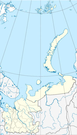
Karpogory ( Russian Карпого́ры ) is a village (selo) in northwestern Russia . It belongs to the Arkhangelsk Oblast and has 4443 inhabitants (as of October 14, 2010). It is the administrative center of the Rajons Pinega .
geography
Karpogory is located about 217 km east of the Oblast capital Arkhangelsk . It is located on the right side of the Pinega River .
history
Karpogory has been the administrative center of Pinega Raion since 1959. In 1969 a railway line from Arkhangelsk to Karpogory started to be built. Originally, Karpogory was supposed to act as a junction for further railway lines to the village of Leschukonskoje and to Wendinga ( Komi Republic ). However, these projects were discontinued due to a lack of financial resources. On December 28, 1975 the first train ran and in 1977 the railway line was officially opened for passenger traffic. In 1980 the construction of the Mesen Railway ( Мезенская железная дорога ) from Karpogory to Leschukonskoye finally began . This was intended in particular to transport wood products from the region to the Oblast capital Arkhangelsk. The construction work on the line proceeded slowly and was finally completely stopped in 1990. The 31-kilometer stretch to the Jawsora ( Явзора ) station, which had been completed by then , was primarily used to transport wood. Since 1992, there has been a settlement at the end of the route, Shanghai ( ангас ).
Population development
The following overview shows the development of the population of Karpogory.
| year | Residents |
|---|---|
| 1939 | 1,783 |
| 1959 | 2,222 |
| 1970 | 3,193 |
| 1979 | 4,366 |
| 1989 | 5,335 |
| 2002 | 4,617 |
| 2010 | 4,443 |
Note: census data
Economy and Infrastructure
There is a small airport to the north of the village. There is a road connection to Arkhangelsk, which crosses the Pinega twice. However, especially in spring, especially after rainfall, the road is not passable by normal vehicles. The Karpogory – Passaschirskie railway station is located about three kilometers north of the village center .
Karpogory owns a district hospital, library, middle school and college branch, among other things.
Web links
- Pinega Raion on the Arkhangelsk Oblast side (Russian)
- History of the Mesen Railway (Russian)
- History of the Arkhangelsk – Karpogory Railway Link (Russian)
Individual evidence
- ↑ a b Itogi Vserossijskoj perepisi naselenija 2010 goda. Tom 1. Čislennostʹ i razmeščenie naselenija (Results of the All-Russian Census 2010. Volume 1. Number and distribution of the population). Tables 5 , pp. 12-209; 11 , pp. 312–979 (download from the website of the Federal Service of State Statistics of the Russian Federation); Čislennost 'naselenija po municipal'nym obrazovanijam i naselennym punktam Archangel'skoj oblasti, vključaja Neneckij avtonomnyj okru Itogi Vserossijskoj perepisi naselenija 2010 Goda (population number of municipal structure and places the Arkhangelsk including the Autonomous circles Nenets results of the All-Russian census 2010.) Table (Download from the website of the Federal Service for State Statistics of Arkhangelsk Oblast)

