
Talashsky Aviagorodok
| settlement
Talashsky
Aviagorodok Талажский Авиагородок
|
||||||||||||||||||||||
|
||||||||||||||||||||||
|
||||||||||||||||||||||
.svg)

Talaschski Aviagorodok ( Russian Талажский Авиагородок , scientific transliteration Talažskij Aviagorodok ) is a settlement in northwestern Russia with 3298 inhabitants (as of October 14, 2010). It belongs to Arkhangelsk Oblast .
location
Talashsky Aviagorodok is located about 11 kilometers northeast of the Oblast capital Arkhangelsk , directly south of Talagi Airport . The settlement is administratively part of the Arkhangelsk district ( Муниципальное образование "ARhangelsk" , municipal entity "Arkhangelsk"). About four kilometers northwest of Talaschski Aviagorodok is on the left bank of the Kuznetschicha, the eponymous settlement Talagi .
history
The Talaschski Aviagorodok settlement was established in the early 1960s with the construction of the Talagi airport, which, in addition to civil aviation, was used as a military airfield for the 518th fighter regiment of the Soviet and Russian air defense forces based in the settlement until 1998 . Talashsky Aviagorodok had at that time the status of a military town ( Военный городок ) and accordingly served to accommodate soldiers, military employees and their families. In 1999 a MiG-31 was erected as a memorial near the airport in honor of the air defense units .
Economy and Infrastructure
The majority of the population works at the airport. There is a school, two kindergartens, a stadium and small shops. The Church of St. Barbara ( Храм святой великомученицы Варвары ) was founded in 2001 and has been located in a converted two-story former army building since 2003.
traffic
Talashsky Aviagorodok is connected to Arkhangelsk by the Talashskoje shot road. Several bus and marshrutka lines operate between the settlement and Arkhangelsk .
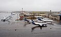
Talagi Airport airfield. Residential buildings of Talashsky Aviagorodok in the background
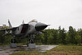
MiG-31 as a memorial in honor of the Air Defense Forces


Individual evidence
- ↑ a b Itogi Vserossijskoj perepisi naselenija 2010 goda. Tom 1. Čislennostʹ i razmeščenie naselenija (Results of the All-Russian Census 2010. Volume 1. Number and distribution of the population). Tables 5 , pp. 12-209; 11 , pp. 312–979 (download from the website of the Federal Service of State Statistics of the Russian Federation); Čislennost 'naselenija po municipal'nym obrazovanijam i naselennym punktam Archangel'skoj oblasti, vključaja Neneckij avtonomnyj okru Itogi Vserossijskoj perepisi naselenija 2010 Goda (population number of municipal structure and places the Arkhangelsk including the Autonomous circles Nenets results of the All-Russian census 2010.) Table (Download from the website of the Federal Service for State Statistics of Arkhangelsk Oblast)
- ↑ Law on the Status and Limits of Territories of Municipal Constructions of Arkhangelsk Oblast. / "О статусе и границах территорий муниципальных образований в Архангельской области" Russian; accessed on October 17, 2016
- ^ Church of St. Barbara on the official site of the Archangelsk and Kholmogory eparchy in Russian; reviewed in September 2012
Administrative center: Arkhangelsk
Beluschja Guba | Beresnik | Cholmogory | Dvinskoi | Gorka Muravyovskaya | Ilyinsko-Podomskoye | Jarensk | Jemza | Jerzewo | Kargopol | Karpogory | Kamenka | Katunino | Kisema | Konjowo | Konosha | Koryashma | Kotlas | Krasnoborsk | Kuloi | Leschukonskoye | Lesnaya Rechka | Lukovetsky | Maloschuika | Mesen | Mirny | Njandoma | Novodvinsk | Oboserski | Oksowski | Oktyabrsky | Onega | Pinega | Plesetsk | Podjuga ] | Privodino | Puksoosero | Samoded | Sawinski | Schenkursk | Schipitsyno | Severooneschsk | Severodvinsk | Solvychegodsk | Talashsky Aviagorodok | Ujemsky | Urdoma | Welsk | Verkhnyaya Toima | Vytschegodski