La Croix-Valmer
| La Croix-Valmer | ||
|---|---|---|

|
|
|
| region | Provence-Alpes-Cote d'Azur | |
| Department | Var | |
| Arrondissement | Draguignan | |
| Canton | Sainte-Maxime | |
| Community association | Golfe de Saint-Tropez | |
| Coordinates | 43 ° 12 ' N , 6 ° 34' E | |
| height | 0-369 m | |
| surface | 22.28 km 2 | |
| Residents | 3,780 (January 1, 2017) | |
| Population density | 170 inhabitants / km 2 | |
| Post Code | 83420 | |
| INSEE code | 83048 | |
| Website | http://www.lacroixvalmer.fr/ | |
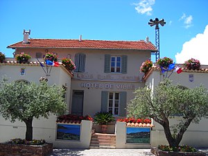
 Mairie La Croix-Valmer |
||
La Croix-Valmer is a French municipality with 3780 inhabitants (at January 1, 2017) in the department of Var in the region Provence-Alpes-Cote d'Azur on the peninsula of Saint-Tropez on the Côte d'Azur . It lies between Le Lavandou in the west and Saint-Tropez in the east. Originally belonging to the area of the neighboring municipality of Gassin , it achieved municipal independence on April 6, 1934 .
location
La Croix-Valmer is located south of the Massif des Maures at Cap Camarat near the N 98 , 880 kilometers south of Paris , 70 kilometers east of Toulon and 75 kilometers west of Nice .
Personalities
- Klaus Harpprecht (1927–2016), German journalist and book author who lived and died in La Croix-Valmer
- Renate Lasker-Harpprecht (* 1924 in Breslau ), German-French author and journalist who lives in La Croix-Valmer
Web links
Commons : La Croix-Valmer - Collection of images, videos and audio files
