
Eisleben district
| Basic data | |
|---|---|
| District of the GDR | Hall |
| County seat | Lutherstadt Eisleben |
| surface | 311 km² (1989) |
| Residents | 69,489 (1989) |
| Population density | 223 inhabitants / km² (1989) |
| License Plate | K and V (1953–1990) KG and VG (1974–1990) EIL (1991–1994) |
  |
|
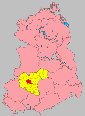
| The Eisleben district in the Halle district (clickable map) |
|
The Eisleben district was a district in the Halle district of the GDR . From 1950 to 1952 and from 1990 to 1994 it existed as the district of Eisleben , from 1990 in the state of Saxony-Anhalt . The district is now part of the Mansfeld-Südharz district in Saxony-Anhalt. The seat of the district administration was in Lutherstadt Eisleben .
geography
The Eisleben district bordered clockwise in the north, starting with the districts of Hettstedt , Saalkreis , Querfurt and Sangerhausen .
history
On July 1, 1950, the first regional reform took place in the state of Saxony-Anhalt in the GDR . From the previously independent city Eisleben , the Mansfeld Seekreis and part of Mansfeld mountainous district was the district Eisleben formed. In a further regional reform , the district of Eisleben gave up parts of the area to the new districts of Bernburg and Hettstedt on July 25, 1952 . From the remaining part of the district, together with parts of the old district Sangerhausen the county Eisleben formed of the newly formed District Hall was assigned.
On May 17, 1990, the district was renamed the Eisleben district. On the occasion of the reunification of the two German states, the district was awarded to the re-established state of Saxony-Anhalt in October 1990 . During the district reform of 1994 it went up in the district of Mansfelder Land . This district merged on July 1, 2007 with the district of Sangerhausen to form the new district of Mansfeld-Südharz.
Population development
| Eisleben district | ||||||||
|---|---|---|---|---|---|---|---|---|
| year | 1960 | 1971 | 1981 | 1989 | ||||
| Residents | 101,467 | 89.201 | 75,846 | 69,489 | ||||
cities and communes
After the administrative reform of 1952, the Eisleben district included the following towns and communities:
On April 1, 1979, the Eisleben district gave the Schwittersdorf community to the Saalkreis.
economy
The economy of the district was dominated by copper mining and copper processing by the VEB Mansfeld Kombinat Wilhelm Pieck .
traffic
The F 80 in the direction of Nordhausen and Halle , the F 180 in the direction of Magdeburg and Erfurt and the F 242 in the direction of Harz served national road traffic . In addition, the Eisleben district was crossed by the Halle – Eisleben – Nordhausen and Berlin – Sangerhausen – Blankenheim railway lines .
License Plate
Motor vehicles (with the exception of motorcycles) and trailers were assigned three-letter distinctive signs from around 1974 to the end of 1990, beginning with the letters KG and VG . The last number plate series used for motorcycles was VH 30-01 to VH 60-00 .
At the beginning of 1991 the district received the distinguishing mark EIL . It was issued until June 30, 1994. It has been available in the Mansfeld-Südharz district since November 27, 2012 .
Individual evidence
- ↑ a b Statistical Yearbooks of the German Democratic Republic. In: DigiZeitschriften. Retrieved October 6, 2009 .
- ↑ a b Federal Statistical Office (ed.): Municipalities 1994 and their changes since 01.01.1948 in the new federal states . Metzler-Poeschel, Stuttgart 1995, ISBN 3-8246-0321-7 .
- ↑ Law on the self-administration of municipalities and districts in the GDR (municipal constitution) of May 17, 1990
- ↑ StBA Area: changes from 01.01. until December 31, 2007
- ↑ Law on the further democratization of the structure and functioning of the state organs in the state of Saxony-Anhalt of July 25, 1952
- ↑ Andreas Herzfeld: The history of the German license plate . 4th edition. German Flag Society V., Berlin 2010, ISBN 978-3-935131-11-7 , pp. 302 f .
- ↑ Andreas Herzfeld: The history of the German license plate . 4th edition. German Flag Society V., Berlin 2010, ISBN 978-3-935131-11-7 , pp. 519 .