
Lobsigensee
| Lobsigensee | ||
|---|---|---|

|
||
| Lobsigensee with Seebach outflow and Lobsigen in the background | ||
| Geographical location | Bernese Seeland in the Swiss Plateau | |
| Tributaries | Precipitation , underground infiltration and drainage from the surrounding cultivated land | |
| Drain | Seebach → Lyssbach → Alte Aare → Aare → Rhine | |
| Location close to the shore | Lobsigen and Seedorf | |
| Data | ||
| Coordinates | 589 318 / 208850 | |
|
||
| Altitude above sea level |
515 m above sea level M. geo.admin.ch |
|
| surface | 1.73 ha | |
| length | 180 m | |
| width | 130 m | |
| volume | 21,953 m³ | |
| Maximum depth | 2.5 m | |
| Middle deep | 1.27 m | |
| Catchment area | 93.2 ha | |
|
particularities |
||

The Lobsigensee - or officially also Lobsigesee - is a lake in the municipality of Seedorf in the canton of Bern in Switzerland . It got its name from the place Lobsigen in the immediate vicinity.
location
The Lobsigensee is topographically located in the southeastern edge of the Bernese Seeland on a slightly lowered and slightly sloping, trough-shaped , 500 m × 2100 m plateau on the northern slope of the Frienisberg . The body of water is 15 km from the outskirts of Bern and three kilometers from Aarberg .
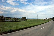
The lake is located in the municipality of Seedorf, 100 m north of Unterdorfstrasse from Lobsigen to Seedorf - as the crow flies around 500 m northeast of Lobsigen and a little over 1100 m southwest of Seedorf - surrounded by a wetland belt with isolated trees and groups of trees - in an open field .
The Lobsigensee can be reached via the main road 236 Aarberg - Bern, which runs through Seedorf . The Lobigesee can be reached in public transport using the Postbus line 105 Bern – Lyss . From Unterdorfstrasse a dirt road leads to and a partially marked footpath around the lake.

Lobsigensee - background foothills of the Jura
Lobsigensee - Unterdorfstrasse towards Seedorf

Lobsigensee - dirt road from Unterdorfstrasse to the small lake
.jpg)
.jpg)
.jpg)
Surroundings
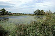
The area of the oval Lobsigensee is surrounded by a ten to 40 meter wide belt of wetlands. This consists of reeds with typical reeds and cattails as well as swamp , bog and bog soil with isolated trees and groups of trees.
Embedded is the area of the natural, even on the shore with floating mats covered Still waters in wetlands , which in turn depends agriculturally occupied arable land are included. The agricultural zone partially extends up to 100 m from the wetland.
On the south-eastern bank there is a raised, wooden viewing platform that allows a view over the pond .

Lobsigensee - viewing platform in the reed belt

Lobsigensee - view from the viewing platform over the lake to the north
Lobsigensee - View from the viewing platform over the lake to the northeast with Aspi near Seedorf in the background

Lobsigensee - Seebach drain
.jpg)
.jpg)
.jpg)
.jpg)
Risk of silting up
The Lobsigensee is mainly fed by precipitation , subterranean infiltration and, most likely, drainage of the surrounding cultivated land, which with almost 85% forms the largest part of the natural catchment area . The outflow takes place at the northern end of the lake through the artificially created Seebach . This - in recent years partially dammed at the lower end by beavers , but without consequences for the lake - flows in a north-easterly direction after almost 5 km, south-east at the beginning of Lyss into the Lyssbach , which in turn flows west of Busswil into the Alte Aare .
His debut took the ecological suffering of the small lake at the latest in 1858. He began the first reclamation through a channel - today Seebach - the then Seedorfmooses that one in ecological understanding fen was and hydrological sense as silting Moor was called. A further drainage of the lake area, also to gain cultivated land and to break down peat , took place in 1928–1934 with the artificial lowering of the lake level by 1.2 m. In the 1940 / 1950s, artificial subsidence and drainage are said to have taken place. Contemporary witnesses report at least drainage work around the lake after 1945.
Through the agriculturally productive area around the Lobsigensee, fertilizer - in the form of liquid manure , liquid manure and manure with ingredients such as phosphorus and, recently decreasing, nitrogen compounds - got into the lake through infiltration. In summer with longer warm phases there is also a lack of oxygen . The pond is considered to be over-fertilized and very productive and can therefore be described as highly eutrophic - to put it simply: nutrient-rich and low in oxygen.
Due to the high nutrient content in the standing, shallow - the maximum lake depth is 2.5 m - there is excessive growth of aquatic plants , as well as zoo and phytoplankton . After they die, the dead biomass forms an ever-increasing layer of silt on the bottom of the shallow lake. Without appropriate measures, the lake is in a few decades silted , and thus be also dried up.
The Lobsigensee is an isolated and oppressed habitat, although it is marked in the protective perimeter of the zoning plan of the community of Seedorf as an ecological protected area - bathing, driving with boats and fishing is therefore generally prohibited - and has been under nature protection since 1955 ; traceable as government council resolution no. 5027 and as NSG no. 31 - nature reserve number - in the community of Seedorf.

Lobsigensee - sign nature reserve
.jpg)
Emergence
The formation of the Lobsigensee must be seen geologically in a larger context, as part of the Frienisberg. This has its origin in the alpine molasse basin , which was formed during the geological stages of Palaeogene and Neogene - known collectively as the Tertiary until 2000 . Within this molasse basin, which was formed between 65.5 and 2.588 million years ago, it lies in the zone that is known as the foreland molasse .
As part of this foreland molasse area , the Frienisberg consists of molasses conglomerate . The surrounding area, the base and large parts of the slope are formed by lower freshwater molasses - formed around 28 to 22 million years ago - overlaid by a sedimentary layer of upper sea molasses - formed around 22 to 16 million years ago. The latter make up the ridges of the Frienisberg.
The currently known surface design was later, during the Würm before about 115'000-10'000 years ago today instead. The Rhone Glacier in particular shaped the landscape in the Swiss Plateau , to which the Bernese Seeland and thus also the Frienisberg belong , through its glacial surface formation . The glacier extended into the Solothurn region , where it met the ice age Aar glacier in the Bern region . The Würm glacial ended around 10,000 years ago today, with the beginning of the Holocene , the "now time" in the Quaternary period on the geological time scale, which continues to this day .
As a result of its melting back from the Swiss Plateau 16,000–18,000 years ago, the Ice Age Rhone Glacier also left a moraine landscape in the Swiss Plateau . This had numerous trough-shaped troughs in the form of small lakes, so-called dead ponds or dead ice pools, formed by huge chunks of ice . Many of these Ice Age lakes have silted up and only a few are left.
One of these still existing dead ponds is the Lobigesee, which may have been significantly larger in the past. An indication of the former extent is provided by the presence of sea chalk , which is often found under silting bogs and indicates the existence of open water before the bog formed. The sea chalk can be found in two sediment layers, at depths of 7.4–7.6 m and 7.7–7.8 m, which means 10,000–11,000 years ago in terms of age.
In the same period and in a comparable way as the Lobsigensee, the Inkwiler and Burgäschisee lakes , located approximately 30 km and 33 km to the north-east, were formed, which, interestingly, are both located on the cantonal border between Bern and Solothurn .
Settlement history
The oldest settlement remains found at Lobsigensee are around 5900 years old. They are attributed to the Cortaillod culture , an archaeological culture of the Neolithic , also known as the Neolithic . They also assign other classifications to the Early Neolithic , each referring to the same period. Particularly interesting in this temporal context is the documentation from the year 2007 of an even older, Mesolithic - Middle Stone Age - layer under the prehistoric pile structures , which could be obtained using a narrow cut of the shed . However, their meaning is still unclear and requires further, more comprehensive clarification.
The size of the currently known settlement area is around 3000 square meters, which corresponds to an oval-shaped zone of around 40 m × 75 m. It is located on the north to north-west bank, between Seebach and Allmit .
The settlement on Lobsigensee is not a pile dwelling settlement in the popular or romantic sense, but a wetland settlement . As an indication of this, the remains of plank paths that have been found, which have been laid on the damp bank ground and that overall only very few wooden piles have been found. As drilling results further showed, this settlement is likely to have been on an island and not in sea water near the shore. Which also suggests that the Lobsigensee was much larger four and more millennia ago today.
The other finds from the settlement consist mainly of conspicuously small shattered ceramics , flint , bone tools , a few stone axes , numerous pieces of clay from house floors and animal bones, which are likely to be food waste from the previous residents. Particularly interesting are the aforementioned flint , also known as flint stone or flint, which comes from the southern Alps and rock crystal from the Alps .
The latter finds leave open whether the settlers traded or undertook extensive hunting trips, in addition to growing crops, collecting herbs or local hunting and fishing. The question of how long the settlement lasted and whether the Lobsigensee was settled several times is also open.
The first archaeological finds are likely to have occurred with the first lowering of the lake level to dump the Seedorfmoos in the middle of the 19th century. 50 years later, the Historical Museum of Bern carried out an exploratory excavation itself based on private finds in 1909 and confirmed the discovery. At that time stakes, rod mesh, clay, bones and shards were found. In 1924 and 1953, rather smaller excavations took place. In 1953 hardly any stakes were found. In 2005 and 2007, after another interruption of more than 50 years, further archaeological explorations were carried out using contemporary methods in order to determine the exact location and extent of the site, which was still unknown until then. It was also found that the groundwater level was permanently below the archaeological find layers. What their irretrievable destruction means, since the water as a conserving element is no longer available.
To determine the age of the finds from the Neolithic settlement, stratigraphy - to put it simply, the archaeological age determination by analyzing the individual sediment deposits and their relationship to each other - was used in the last decades . The samples for analysis are brought to the surface by drilling - to take soil samples as drill core - or by search cut - an excavation technique in which a profile is dug to probe the area. - Dendrochronological dating is currently not possible due to the short tree ring sequences and the only limited suitability of wood species.
The findings of the archaeobotanical investigations from the 1980s help to determine the age of the settlement site. The drill cores obtained from almost 10 m deep boreholes were examined primarily by means of pollen analysis , scientifically known as palynology. The core consists of gyttja up to 7.4 m , two layers of lake chalk and the rest of silt . Whereby the whole core is offset with pollen concentrations according to the respective time. So, in the period of the Neolithic settlement, a maximum of herbs.
Part of the UNESCO World Heritage Site
In 2011, the remains of pile dwellings were with the Lobsigensee 110 other sites in six Alpine countries by the UNESCO in the inventory of the UNESCO World Cultural Heritage added. Six of these sites are located in the canton of Bern - five around Lake Biel and the site at Lake Lobsigensee - as part of a total of 56 sites in Switzerland , which are spread over 15 cantons.
The description of the Lobsigensee of the UNESCO application on the website of the Palafittes sponsoring association :
- CH-BE-05, Seedorf - Lobsigensee: The site contains an impressive stratigraphy of Neolithic cultural layers dating from around 3900 BC. Begins. The site represents an unusual settlement, presumably on an earlier island, and complements the nearby Neolithic settlements on Lake Biel. The material culture of the site shows connections to the Alpine region. Finally, in the course of a narrow search cut in 2007, a mesolithic layer was documented under the pile structures - another very interesting aspect of Seedorf - Lobsigensee.
After several years of preparation by interested specialist groups from six countries - Germany , France , Italy , Austria , Switzerland and Slovenia - organized as an association Palafittes based in Bern , Switzerland from June 2008, the nomination dossier for the international candidacy for prehistoric pile dwellings around the Alps as UNESCO World Heritage. 111 sites with the greatest scientific potential were selected from over 1000 known sites for this serial candidacy. This also applies to the CH-BE-05 Lobsigensee site, which was preferred to the Moossee site due to its better conservation status .
In order to improve the legal and material protection of the Lobsigensee site in the future, measures are planned, such as the expansion of the marine protection zone and the restoration of the wetland with continuous monitoring of soil moisture . Land purchases were also made in this context.

Lobsigensee - excavation field in the background Seedorf

Lobsigensee - excavation field with one of the tensiometers for measuring soil moisture
.jpg)
.jpg)
See also
swell
- Markus Zeh: Lobsigensee. (PDF; 746 kB) In: Kleinseen 2003. Office for Water Protection and Waste Management of the Canton of Bern (GAB) and Water and Soil Protection Laboratory (GBL), 23 November 2004, p. 53, pages 40–43 , accessed on 11 August 2011 .
- Albert Hafner: Prehistoric settlement remains in lakes and moors: an extraordinary cultural heritage under water. (PDF; 470 kB) In: NIKE-Bulletin 1-2 / 2009. National Information Center for the Preservation of Cultural Goods (NIKE), March 31, 2009, p. 2 , accessed on August 11, 2011 .
- Brigitta Ammann: Wet soils as the environmental archive of the Seeland. (PDF; 829 kB) In: Seebutz 2009 - Heimatbuch des Seeland and Murtenbiet. W. Gassmann AG, 2009, p. 6, pages 43-47 , accessed on August 18, 2011 .
- Albert Hafner: Archaeological excavations in Seedorf, Lobsigensee - The creeping destruction of extraordinary cultural assets. (PDF; 1.8 MB) In: Seebutz 2009 - Heimatbuch des Seeland and Murtenbiet. W. Gassmann AG, 2009, p. 6, pages 37-42 , accessed on August 15, 2011 .
Web links
- Werner E. Stöckli: Neolithic. In: Historical Lexicon of Switzerland .
- Pierre Crotti: Mesolithic. In: Historical Lexicon of Switzerland .
- Kurt Altorfer: pile dweller. In: Historical Lexicon of Switzerland .
- Martin Trachsel: Bank settlements. In: Historical Lexicon of Switzerland .
- Official website of the water and soil protection laboratory of the Canton of Bern
- Official website of the Archaeological Service of the Canton of Bern
- Web presence Palafittes - Association to support the UNESCO World Heritage candidacy "pile dwellings in lakes and moors around the Alps"
- Website NIKE - National Information Center for the Preservation of Cultural Assets
- Website Swiss Commission for UNESCO - The eleven World Heritage Sites in Switzerland
- Web presence UNESCO World Heritage in Switzerland - special website of the Swiss UNESCO Commission
- Federal Office of Culture (BAK) - Prehistoric pile dwellings around the Alps are world heritage
- UNESCO Serial-ID: 1363-005 - Name & Location: Lobsigensee - Coordinates: N47 1 58.487 E7 17 59.989 - Area: Property: 1.1 ha (11,000 m²) - Buffer zone: 27.6 ha (276,000 m²)
- Pictures Lobsigensee on meteorit.org
- Albert Hafner and Andreas Marti: Seedorf, Lobsigesee. Approaches for an archaeological monitoring of prehistoric bog settlements in the canton of Bern. In: Archeology Bern. Archaeological Service of the Canton of Bern, 2008, pp. 68–71 (4 pages) , accessed on March 23, 2019 .
- Albert Hafner, Marco Achermann, Roland Haab, Rolf Krebs, Luzius Matile, Andreas Marti and Philipp Rentzel: Seedorf, Lobsigesee. First work on monitoring the Neolithic site in 2008. In: Archeology Bern. Archaeological Service of the Canton of Bern, 2009, pp. 102-105 (4 pages) , accessed on March 23, 2019 .
Individual evidence
- ↑ a b Lobsigesee map. In: map.geo.admin.ch. Swiss Confederation and Cantons, accessed on September 27, 2017 .
- ↑ a b c Joachim Guthruf; Katrin Guthruf-Seiler; Markus Zeh: Lobsigensee. (PDF; 36.8 MB) In: Small lakes in the canton of Bern. Office for Water Protection and Waste Management of the Canton of Bern (GSA) and Water and Soil Protection Laboratory (GBL), August 1999, p. 255, pages 126–128 , accessed on September 1, 2018 .
- ↑ Federal Chancellery : Through Road Ordinance SR 741.272. Appendix 2 - List of main streets - B. Main streets that are not marked with the «number plate for main streets» (4.57). In: Systematic Collection of Federal Law SR . Swiss Federal Council , December 18, 1991, accessed on August 9, 2017 (as of January 1, 2016).
- ↑ Employees: Postbus line 105 (Bern – Meikirch – Seedorf – Lyss). (PDF; 99 kB) In: Official course book online. Swiss Post Ltd - PostBus Switzerland Ltd (PAG), December 20, 2010, p. 3 , accessed on August 3, 2011 .
- ↑ TBA employee: Living with the beaver. (PDF; 4.0 MB) In: Report 2011. Civil Engineering Office of the Canton of Bern (TBA), April 27, 2011, p. 36, page 5 , accessed on August 8, 2011 : “The beaver also dammed the Seebach in Lobsigen . "
- ↑ 1858 draining of the Lobsigesee
- ^ Anne-Marie Dubler: Artificial ditch in the 19th century (Lobsigen). In: Historical Lexicon of Switzerland .
- ↑ Anne-Marie Dubler: 1928–1934 artificial lowering of Lobsigensee by 1.2 m (Lobsigen). In: Historical Lexicon of Switzerland .
- ^ Albert Hafner: Media orientation Seedorf-Lobisgensee. Information on the source. (PDF; 16 kB) (No longer available online.) Archaeological Service of the Canton of Bern, November 14, 2007, p. 1 , archived from the original on June 22, 2015 ; accessed on August 8, 2011 : “Artificial lowering of the Lobsigensee lake in the 1940 / 1950s and subsequent possible drainage” Info: The archive link was automatically inserted and not yet checked. Please check the original and archive link according to the instructions and then remove this notice.
- ^ Authors GSA: Chapter 2 Quality of Surface Waters. (PDF; 14.1 MB) 2.4.3 Deficits in lakes - small lakes. (No longer available online.) In: Sector plan for settlement drainage (VOKOS). Government Council of the Canton of Bern , Office for Water Protection and Waste Management (GSA), p. 171, page 38 , archived from the original on September 23, 2015 ; accessed on August 15, 2011 : “ Fig. 2.35 : The Lobsigensee is now heavily overfertilized and very productive. The silting process has been greatly accelerated over the last few decades, primarily through artificial lake level lowering and increased nutrient input from the agricultural catchment area. ” Info: The archive link was automatically inserted and not yet checked. Please check the original and archive link according to the instructions and then remove this notice.
- ^ Markus Zeh: Lobsigensee. (PDF; 746 kB) In: Kleinseen 2003. Office for Water Protection and Waste Management of the Canton of Bern (GSA) and Water and Soil Protection Laboratory (GBL), 23 November 2004, p. 53, page 43 , accessed on 8 August 2011 : "Without artificial interventions (raising the lake level, dredging), the small lake should be completely silted up in a few decades."
- ↑ Urs Känzig-Schoch, Alain Perrenoud: 3 - Nature in the cultural landscape. (PDF; 1.2 MB) In: Priority setting and decision-making in nature conservation, Chapters 1–4. Office for Agriculture and Nature (LANAT) - Nature Conservation Inspectorate of the Canton of Bern, May 5, 2000, p. 22, page 5 , archived from the original on December 6, 2008 ; accessed on May 31, 2016 : "The Lobsigensee in the Bernese Seeland as an example of an isolated and oppressed habitat"
- ↑ Kurt Nuspliger: Government Council Decision No. 5027. (PDF; 173 kB) Protection decision for the Lobsigensee nature reserve, community of Seedorf. (No longer available online.) In: Protocols of the Government Council of the Canton of Bern. Government Council of the Canton of Bern, November 19, 1986, p. 3 , formerly in the original ; accessed on September 11, 2011 : “14. With this protection decision, RRB No. 4871 of August 19, 1955 is repealed. "
- ↑ Employees: nature reserves and objects. (PDF; 336 kB) Directory of the cantonal nature reserves - by municipality (status: December 31, 2006). In: Berner Naturschutz (edition 5.2011). Department of Economic Affairs of the Canton of Bern - Department of Nature Promotion of the Canton of Bern (ANF), May 20, 2011, p. 7, page 3 , accessed on September 11, 2011 (first edition 1994).
- ↑ Brüllhardt et al .: Geological-tectonic map of the Canton of Bern. In: Book presentation "On the Geology of the Canton of Bern". kristalle.ch, accessed on August 17, 2011 (graphic).
- ↑ Brüllhardt et al .: Geological-tectonic map of the Canton of Bern. (PDF; 8.4 MB) In: Bulletin for Applied Geology, Vol. 10/1, July 2005 - Final report of the radon measurement program in the canton of Bern, 1995–2004. Support associations VSP and SFIG, July 2005, p. 17, pages 17–32 , archived from the original ; Retrieved on August 9, 2017 (picture on page 20): " Fig. 1 : Geological-tectonic map of the canton of Bern (Brüllhardt et al. 1981) with canton border."
- ↑ Brigitta Ammann: Wet Soils as Environmental Archives of the Seeland. (PDF; 829 kB) (No longer available online.) In: Seebutz 2009 - Heimatbuch des Seeland and Murtenbiet. W. Gassmann AG, 2009, p. 6, pages 43-47 , archived from the original on September 23, 2015 ; Retrieved on August 18, 2011 : "When the Rhone Glacier retreated from the Seeland between 18,000 and 16,000 years ago today, ..." Info: The archive link was automatically inserted and not yet checked. Please check the original and archive link according to the instructions and then remove this notice.
- ^ Anne-Marie Dubler: Shallow dead ice basin (Lobsigen). In: Historical Lexicon of Switzerland .
- ↑ Brigitta Ammann: Wet Soils as Environmental Archives of the Seeland. (PDF; 829 kB) (No longer available online.) In: Seebutz 2009 - Heimatbuch des Seeland and Murtenbiet. W. Gassmann AG, 2009, p. 6, pages 43-47 , archived from the original on September 23, 2015 ; Retrieved on August 18, 2011 : " Such ice is called dead , because it is no longer in contact with the living, that is, flowing glacier current ." Info: The archive link was automatically inserted and not yet checked. Please check the original and archive link according to the instructions and then remove this notice.
- ↑ Brigitta Ammann: Wet Soils as Environmental Archives of the Seeland. (PDF; 829 kB) (No longer available online.) In: Seebutz 2009 - Heimatbuch des Seeland and Murtenbiet. W. Gassmann AG, 2009, p. 6, pages 43-47 , archived from the original on September 23, 2015 ; Retrieved on August 18, 2011 : "Figure 3: Pollen diagram for the late glacial of the Lobsigensee - lithology " Info: The archive link was inserted automatically and has not yet been checked. Please check the original and archive link according to the instructions and then remove this notice.
- ^ Anne-Marie Dubler : Cortaillod culture (Lobsigen). In: Historical Lexicon of Switzerland .
- ^ A b aid: Lobsigensee: rescue excavation in the Neolithic bank settlement. In: Media release of the Canton of Bern. Archaeological Service of the Canton of Bern, November 14, 2007, accessed on August 23, 2011 : “The settlement area is around 3,000 square meters. - The drilling profiles also show that the prehistoric settlement was built on an island in what used to be a much larger lake. "
- ^ Albert Hafner: Archaeological excavations in Seedorf, Lobsigensee - The creeping destruction of exceptional cultural assets. (PDF; 1.8 MB) (No longer available online.) In: Seebutz 2009 - Heimatbuch des Seeland and Murtenbiet. W. Gassmann AG, 2009, p. 6, pages 37-42 , archived from the original on February 3, 2016 ; accessed on August 15, 2011 : “Figure 2: Seedorf, Lobsigensee. Plan of the boreholes from 2005, the excavation areas from 2005 and 2007 as well as the expansion of the Neolithic settlement area. ” Info: The archive link was inserted automatically and has not yet been checked. Please check the original and archive link according to the instructions and then remove this notice.
- ^ Albert Hafner: Prehistoric settlement remains in lakes and moors: an extraordinary cultural heritage under water. (PDF; 470 kB) (No longer available online.) In: NIKE-Bulletin 1–2 / 2009. National Information Center for the Preservation of Cultural Goods (NIKE), March 31, 2009, p. 2 , archived from the original on November 17, 2015 ; Retrieved on August 11, 2011 : "Excellently preserved remains of the first villages in Switzerland can be found not only on the large pre-Alpine lakes, but also in the fens of small lakes in the moraine landscape, such as the Lobsigensee in the community of Seedorf BE." Info: Der Archive link was inserted automatically and has not yet been checked. Please check the original and archive link according to the instructions and then remove this notice.
- ↑ Brigitta Ammann: Wet Soils as Environmental Archives of the Seeland. (PDF; 829 kB) (No longer available online.) In: Seebutz 2009 - Heimatbuch des Seeland and Murtenbiet. W. Gassmann AG, 2009, p. 6, pages 43-47 , archived from the original on September 23, 2015 ; Retrieved on August 18, 2011 : "Figure 4: Pollen diagram for the Holocene of Lobsigensee: ... at the time of the Neolithic settlement, a small maximum of herbs can be seen in yellow" Info: The archive link was automatically inserted and not yet checked. Please check the original and archive link according to the instructions and then remove this notice.
- ^ Staff association Palafittes: Map - Three Lakes Region / Map - Three Lakes Region. (JPG) (No longer available online.) Palafittes Association, 2010, p. 1 , archived from the original on September 25, 2013 ; Retrieved on August 22, 2011 (English, 1.6 MB): “CH-BE-05” Info: The archive link was automatically inserted and not yet checked. Please check the original and archive link according to the instructions and then remove this notice.
- ↑ Employees of the Palafittes association: Map - Small lakes of the Swiss Plateau / Map - Small lakes of the Swiss Plateau. (JPG; 661 KB) (No longer available online.) Palafittes Association, 2010, p. 1 , archived from the original on September 25, 2013 ; accessed on August 22, 2011 (English): "CH-BE-05 Lake Lobsigen"
- ↑ Staff: Pile dwelling settlements in Zealand. (PDF; 4.7 MB) In: newsnetz.ch. Tamedia AG , June 28, 2011, p. 1 , accessed on August 11, 2011 (graphic).
- ^ Staff: Canton of Bern. CH-BE-05, Seedorf-Lobsigensee. (No longer available online.) In: UNESCO World Heritage. Association Palafittes, archived from the original on May 31, 2016 ; accessed on May 31, 2016 (click on “+ Bern”).
- ^ Staff: Volume II: Id-files of the component parts of the serial. (PDF; 4.8 MB) CH-BE-05 Seedorf - Lobsigensee. (No longer available online.) In: UNESCO-Nomintion file. Verein Palafittes, 2010, p. 95, pages 36-39 , archived from the original on April 25, 2012 ; accessed on August 22, 2011 (English, "... local planning for Bienne (municipality)" should be Seedorf instead of Bienne). Info: The archive link was inserted automatically and has not yet been checked. Please check the original and archive link according to the instructions and then remove this notice.
- ↑ Employees: Additional information / Additional information. (PDF; 7.0 MB) (No longer available online.) Palafittes Association, February 23, 2011, p. 153, page 41 , archived from the original on September 24, 2015 ; Retrieved on August 22, 2011 (English): "... the preservation conditions of the site are not as good as at other sites. Therefore, the site has been removed from the list in favor of CH-BE-05. " Info: The archive link was automatically inserted and not yet checked. Please check the original and archive link according to the instructions and then remove this notice.
- ↑ Employees: 3.4 Master Plan and Measures (Regional / Local). (PDF; 1.2 MB) (No longer available online.) In: Management Plan Version 2.0. Palafittes Association, August 3, 2011, p. 252, pages 48–299, on pages 117 and 118 , archived from the original on June 22, 2015 ; accessed on August 22, 2011 . Info: The archive link was inserted automatically and has not yet been checked. Please check the original and archive link according to the instructions and then remove this notice.

Cultural heritage: old town of Bern (1983) | St. Gallen Abbey District (1983) | Benedictine convent St. Johann in Müstair (1983) | Three castles and fortifications of Bellinzona (2000) | Lavaux Vineyard Terraces (2007) | Albula and Bernina lines of the Rhaetian Railway (2008) | La Chaux-de-Fonds and Le Locle , watchmaking and urban planning (2009) | Prehistoric pile dwellings around the Alps (2011) | The architectural work of Le Corbusier : Villa Le Lac and Maison Clarté (2016)
Natural heritage: Swiss Alps Jungfrau-Aletsch (2001) | Monte San Giorgio (2003) | Tectonic Arena Sardona (2008)