Londa (Tuscany)
| Londa | ||
|---|---|---|

|
|
|
| Country | Italy | |
| region | Tuscany | |
| Metropolitan city | Florence (FI) | |
| Coordinates | 43 ° 52 ' N , 11 ° 34' E | |
| height | 226 m slm | |
| surface | 59 km² | |
| Residents | 1,865 (Dec. 31, 2019) | |
| Population density | 32 inhabitants / km² | |
| Post Code | 50060 | |
| prefix | 055 | |
| ISTAT number | 048025 | |
| Popular name | Londesi | |
| Patron saint | Immacolata Concezione (December 8th) | |
| Website | Londa municipality | |
Londa is a municipality with 1865 inhabitants (as of December 31, 2019) in the metropolitan city of Florence in the Tuscany region in Italy .
geography
The community extends over about 59 km² . It is located around 30 km northeast of the provincial and regional capital of Florence on the Rincine (every 6 km in the municipality) and Moscia (5 of 14 km in the municipality) and is part of the Comunità montana Montagna Fiorentina.
The districts include Bucigna, Caiano, Caspriano, Fornace, Petroio, Rata, Rincine, Sambucheta, San Leolino, Vicorati and Vierle.
The neighboring municipalities are Dicomano , Pratovecchio ( AR ), Rufina , San Godenzo and Stia (AR).
history
The place was probably already inhabited by the Etruscans . Traces of this from the 6th century BC were found here. Chr. Found. The grave stela that is now in the National Archaeological Museum of Florence is dated to the 5th century BC. Dated. Many of the districts, such as B. Bucina, Caiano, Caspriano and Petronio, are of Roman origin who populated the area around the 3rd century AD.
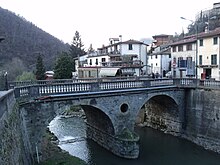
In the Middle Ages the place was controlled by the Guidi and then by the Counts Bardi until it fell to Florence in 1375. The municipality became a municipality in 1776 by a decree of Leopold II , but it only became a free municipality in 1835. The place was badly damaged by an earthquake in 1929 and by the Second World War in 1944, in which the bridge was destroyed. The name of the place probably refers to the word L'onda (The Wave), referring to the two rivers that cross the place.
Attractions
- Chiesa di Santa Maria a Caiano , already mentioned in 1276 church in the district of Caiano.
- Chiesa di Santa Maria a Rata , church from the 12th century in the district of Rata.
- Chiesa di San Lorenzo a Fornace , 12th century church in the Fornace district.
- Oratorio di Montedomini , oratorio from the 16th century in the district of Vicorati.
- Pieve di San Leolino , Pieve , first mentioned in 1103, but probably older.
- Pieve di Sant'Elena a Rincine , Pieve in the Rincine district, mentioned as early as 1274, contains the work Madonna col Bambino e quattro santi by Benedetto Buglioni .
Events
- Palio della Brocca : The Palio takes place in the first two weeks of July and is named after the wine-filled jug (brocca) to be won. The event has been known since the 13th century and has been held again since 2003. The districts of Caiano, Fornace, Petroio, Rata, Rincine and Vierle as well as the main town Londa and since 2009 Vicorati compete against each other. Four of the eight locations reach the final, where they compete in six different competitions. These include walking on stilts and tug of war . Rata won the first competition after the resumption, after that Caiano won the pitcher three times.
Community partnerships
literature
- Emanuele Repetti: LONDA, L'ONDA, altre volte detto Isola in Val di Sieve. In Dizionario Geografico Fisico Storico della Toscana (1833–1846), online edition of the University of Siena (pdf, ital.)
Web links
Individual evidence
- ↑ Statistiche demografiche ISTAT. Monthly population statistics of the Istituto Nazionale di Statistica , as of December 31 of 2019.
- ↑ Official website of the Sistema Informativo Ambientale della Regione Toscana (SIRA) on the rivers in Londa , accessed on June 3, 2014 (Italian)
- ↑ a b Official website of the municipality of Londa ( page no longer available , search in web archives ) Info: The link was automatically marked as defective. Please check the link according to the instructions and then remove this notice. , accessed January 26, 2010
- ↑ Official website of Ludorum Dies ( memento of the original from July 6, 2009 in the Internet Archive ) Info: The archive link was automatically inserted and not yet checked. Please check the original and archive link according to the instructions and then remove this notice. , accessed February 25, 2011
- ↑ Official website of the municipality of Londa ( Memento of the original from January 19, 2012 in the Internet Archive ) Info: The archive link was inserted automatically and has not yet been checked. Please check the original and archive link according to the instructions and then remove this notice. , accessed January 26, 2010


