
Vinci (Tuscany)
| Vinci | ||
|---|---|---|

|
|
|
| Country | Italy | |
| region | Tuscany | |
| Metropolitan city | Florence (FI) | |
| Coordinates | 43 ° 47 ' N , 10 ° 55' E | |
| height | 97 m slm | |
| surface | 54 km² | |
| Residents | 14,691 (Dec. 31, 2019) | |
| Population density | 272 inhabitants / km² | |
| Post Code | 50059 | |
| prefix | 0571 | |
| ISTAT number | 048050 | |
| Popular name | Vinciani | |
| Patron saint | Sant'Andrea (November 30th, St. Andrea's Day) | |
| Website | Vinci | |
 Panorama of Vinci |
||

Vinci is an Italian municipality with 14,691 inhabitants (as of December 31, 2019) near the city of Empoli in the metropolitan city of Florence , Tuscany region .
geography
.svg)
The place is about 97 m above sea level and the municipality area is about 54 km². The provincial and regional capital of Florence is about 36 km to the east, the nearest larger city is Empoli, about 7 km to the south. The municipality is located in the Valdarno Inferiore (lower Arno valley or lower Arno valley) in the climatic classification of Italian municipalities in zone D, 1,765 GG south of the Montalbano mountain . The most important body of water in the municipality is the Arno , which is the municipal boundary to Empoli in the south of the municipality (2 km). Other important bodies of water are the Torrenti (torrents) Streda (11 of 11 km in the municipality) and Vincio (7 of 15 km in the municipality).
The districts include Anchiano , Apparita (61 m, approx. 160 inhabitants), Barano (210 m, approx. 30 inhabitants), La Stella (60 m, approx. 180 inhabitants, partly part of Lamporecchio), Piccaratico (33 m , approx. 30 inhabitants), Salvino (160 m, approx. 20 inhabitants), Sant'Ansano (85 m, approx. 200 inhabitants), Spicchio / Sovigliana (25 m, approx. 7600 inhabitants, partly also belongs to Capraia e Limite and Empoli), Toiano (85 m, approx. 200 inhabitants) and Vitolini . The main town Vinci has about 1550 inhabitants.
The neighboring municipalities are Capraia e Limite , Carmignano ( PO ), Cerreto Guidi , Empoli , Lamporecchio ( PT ) and Quarrata (PT).
history
Vinci Castle was first mentioned in the 11th century. The town was owned by the Guidi until August 12, 1254 , after which it was captured by the Republic of Florence and declared a municipality. After the Battle of Montaperti in 1260, from which Florence was defeated, the Guidi again took power in the town, but in 1273 they sold Vinci back to Florence. In 1315 the population rose under the leadership of Uguccione della Faggiola against the lords from Florence, who took the place again in April 1316. Vinci's first statutes were drawn up in 1383.
After the territorial reform of Pietro Leopoldo d'Asburgo-Lorena in 1774 , Vinci belonged to Cerreto Guidi, after the French occupation the place became an independent municipality again in 1814. President Luigi Einaudi declared the place to be a city on July 15, 1954 due to its historical importance. In 1961 the director and honorary citizen Friedrich Vordemberge founded an "outside studio" for the art students of the Cologne factory schools , which existed until 1971.
Attractions
- Leonardo da Vinci's birthplace in the district of Anchiano . Located about 3 km north of Vinci and contains a reproduction of the Mappa del Valdarno by Leonardo da Vinci.
- Castello dei Conti Guidi , castle in the center of the village, also called Castello della Nave (ship castle ), was built around the year 1000 and has been owned by the municipality of Vinci since 1919. It houses the Museo Leonardiano di Vinci , founded in 1919, with drawings, models and replicas of Leonardo's machines and inventions. as well as the private Museo ideal Leonardo da Vinci founded by Alessandro Vezzosi
- L'Uomo di Vinci , wooden sculpture by Mario Ceroli, 1987; after: The Vitruvian Man by Leonardo.
- Piazza dei Conti Guidi, new square design by Mimmo Paladino , 2006
- Biblioteca Leonardiana , a library founded in 1928, contains over 7,000 monographs on Leonardo da Vinci.
- Chiesa di Santa Croce , church in the town center. In the 13th century it was subordinate to the Pieve di San Giovanni Battista in Greti. Has been restored and renewed several times, today's appearance comes from the restoration from 1925 to 1935. The campanile was rebuilt in the 19th century.
- Il Cavallo (The Horse), a sculpture that has been in Piazza della Libertà since 2001 . It was cast from bronze based on a clay model by the Japanese-American artist Nina Akamu, made according to Leonardo's designs for the planned equestrian statue of Francesco Sforza .
- Santuario della Santissima Annunziata , sanctuary just outside the city walls, built in the 16th century. It contains the panel painting Annunciazione (around 1520), attributed to Fra Paolino da Pistoia (Paolo di Bernardino di Signoraccio, 1488–1547).
- Chiesa di Santa Maria Assunta a Faltognano , church in Faltognano.
- Chiesa di Santa Maria Assunta a Spicchio , also called a Pagnanamina , church in Spicchio, first mentioned in 1119 and expanded in 1633. Today's appearance is the result of restoration work in the 1960s. The church houses a panel ( Madonna col Bambino ) by Jacopo di Cione (1325-1399), Orcagna's younger brother .
- Chiesa di Santa Maria a Petroio , church of Petroio Castle, destroyed by Castruccio Castracani in 1326 .
- Oratorio dell'Erta , oratory south of Vinci near Spicchio / Sovigliana .
- Pieve di San Giovanni Battista a Sant'Ansano in Greti , Pieve in the district of Sant'Ansano. The church is the oldest in the municipality and was built in 998 by Otto III. mentioned in a diploma. During the Second World War it suffered considerable damage to the campanile, the roof and the portico from the 16th century. Inside, works by Puccio di Simone ( Sant'Ansano tra due Angeli ) and Rutilio Manetti ( Pope Alexander I is released from prison by an angel ) (canvas, 235 × 169 cm, around 1625).
- Pieve di San Pietro , Pieve in the district of Sant'Amato, which dates from the 12th century.

The Castello dei Conti Guidi in the center

Museo Leonardiano
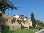
City wall and Uomo di Vinci

Piazza dei Guidi at night; designed by Mimmo Paladino
Piazza dei Guidi, designed in 2006

Piazza dei Guidi at night
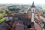
View from the Castello to the Church of Santa Croce and Vinci

Pieve di San Giovanni Battista


traffic
- The closest trunk road is the Strada di grande comunicazione Firenze-Pisa-Livorno . The Empoli junction is about 10 km south of Vinci.
- The nearest major train station is Empoli train station. From here there are train connections to Pisa / Livorno , Florence and Siena . There are bus connections from Vinci to Empoli train station.
Personalities
Sons and daughters of the church
- Leonardo da Vinci (1452–1519), polymath and artist, born in the district of Anchiano
- Giulio Masetti (1894–1926), nobleman and racing car driver
- Roberto Filippini (* 1948), Catholic clergyman, Bishop of Pescia
Honorary citizen
- Carlo Pedretti (1928–2018), Italian art historian
- Friedrich Vordemberge (1897–1981), German painter
literature
- Rosanna Caterina Proto Pisani (Ed.): I luoghi della Fede: Empoli, il Valdarno inferiore e la Valdelsa fiorentina. Arnoldo Mondadori Editore , Milan 1999, ISBN 88-04-46788-6 , pp. 106-112.
- Emanuele Repetti: VINCI detto ancora VINCI FIORENTINO nel Val d'Arno inferiore. In: Dizionario Geografico Fisico Storico della Toscana (1833–1846) , online edition of the University of Siena (pdf, ital.)
- Touring Club Italiano : Firenze. Touring Editore, Milan 2007, ISBN 978-88-365-4345-8 , pp. 731 f.
- Giuliano Valdes: Le Terre di Leonardo e Boccaccio. Felici Editore, Pisa 2004, ISBN 88-88327-58-4 , p. 67 ff.
Web links
- Official website of the municipality of Vinci (Italian)
- Website of the Pro Loco in Vinci
- Comuni Italiani to Vinci
- Tuttitalia to Vinci
Individual evidence
- ↑ Statistiche demografiche ISTAT. Monthly population statistics of the Istituto Nazionale di Statistica , as of December 31 of 2019.
- ^ Comuni Italiani
- ↑ Tutti Talia
- ↑ a b c Emanuele Repetti: VINCI detto ancora VINCI FIORENTINO nel Val d'Arno inferiore.
- ↑ Website of the Agenzia nazionale per le nuove tecnologie, l'energia e lo sviluppo economico sostenibile (ENEA), accessed on May 12, 2015 (Italian) (PDF; 330 kB)
- ↑ Official website of the Sistema Informativo Ambientale della Regione Toscana (SIRA) on the rivers in Vinci , accessed on May 11, 2015 (Italian)
- ↑ Official website of ISTAT ( Istituto Nazionale di Statistica ) on 2001 population figures in the province of Florence, accessed on May 11, 2015 (Italian)
- ↑ a b c Giuliano Valdes: Le Terre di Leonardo e Boccaccio.
- ↑ vinciturismo.it , accessed January 20, 2010
- ↑ a b c d Official website of the municipality of Vinci on the history of the place , accessed on May 13, 2015 (Italian)
- ↑ Museum website, English
- ↑ a b c d e Rosanna Caterina Proto Pisani (ed.): I luoghi della Fede: Empoli, il Valdarno inferiore e la Valdelsa fiorentina.
- ↑ Nina Akamu: The Davinci horse accessed on May 11, 2019
- ↑ Alessandro Nesi: PAOLO di Bernardino di Antonio del Signoraccio , in: Dizionario Biografico degli Italiani , Volume 81 (2014), accessed on May 12, 2015 (Italian)
- ^ Fondazione Zeri of the University of Bologna on the work Papa Alessandro I liberato dal carcere da un angelo , with illustration, accessed on May 17, 2019 (Italian)