Lastra a Signa
| Lastra a Signa | ||
|---|---|---|

|
|
|
| Country | Italy | |
| region | Tuscany | |
| Metropolitan city | Florence (FI) | |
| Coordinates | 43 ° 46 ' N , 11 ° 6' E | |
| height | 36 m slm | |
| surface | 43.06 km² | |
| Residents | 19,982 (Dec. 31, 2019) | |
| Population density | 464 inhabitants / km² | |
| Post Code | 50055 | |
| prefix | 055 | |
| ISTAT number | 048024 | |
| Popular name | Lastrigiani | |
| Patron saint |
San Martino (November 11th) |
|
| Website | Lastra a Signa | |
 Lastra a Signa, part of the city walls |
||
Lastra a Signa is an Italian municipality with 19,982 inhabitants (as of December 31, 2019) in the metropolitan city of Florence in the Tuscany region .
geography
The municipality is located around 12 km west of the provincial and regional capital Florence at the confluence of the Arno (4 km in the municipality) and Vingone (2 of 13 km in the municipality). The Pesa flows along the southwestern municipal boundary (6 km in the municipality).
The districts include Bracciatica, Brucianesi, Calcinaia, Carcheri, Ginestra Fiorentina, Inno, La Lisca, La Luna, Lecceto, Malmantile, Marliano, Ponte a Signa, Porto di Mezzo, Quattro Strade, San Martino a Gangalandi, San Romolo, Sant ' Ilario a Settimo, Stagno and Val di Rose.
The neighboring municipalities are Carmignano ( PO ), Montelupo Fiorentino , Montespertoli , Scandicci and Signa .
history
The name comes from the word sandstone (lastre), the second part of the name refers to the proximity to the neighboring community Signa . Until the end of the 13th century the place was still known under the name Lastra a Gangalandi , named after a local Ghibelline noble family. The place was probably inhabited as early as the 11th century as a rest stop on Via Pisana , the ancient connecting road between Pisa and Florence. With the expansion of the Republic of Florence in the 12th century, the place fell under their sphere of influence. The Arno bridges, which are still important today, were built and the city wall was planned in 1326, although this was not completed until the end of the century and was intended as a pre-defense post for Florence.
Attractions
- Cinta muraria del Brunelleschi , historic city wall from the 14th century, planned and built by Filippo Brunelleschi
- Spedale di Sant'Antonio from the 15th century
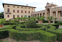
- Villa di Bellosguardo from the 16th century. In 1906 the villa was bought by the tenor Enrico Caruso , and since then it has also been called Villa Caruso . The Enrico Caruso Museum ( Museo Enrico Caruso ), the only one in Italy dedicated to the tenor, opened in the villa in 2012. The museum displays phonographs , gramophones, and Caruso's personal belongings as well as memorabilia.
traffic
- The place has a junction on the Strada di grande comunicazione Firenze-Pisa-Livorno .
Sons and daughters of the church
- Renato Bertelli (1900–1974), artist
- Egisto Pandolfini (1926–2019), football player
literature
- Emanuele Repetti: LASTRA A SIGNA, ossia di GANGALANDI nel Val d'Arno sotto Firenze. In: Dizionario Geografico Fisico Storico della Toscana (1833–1846), online edition of the University of Siena (pdf, ital.)
Web links
- Official website of the municipality of Lastra a Signa (Italian)
- Museo Enrico Caruso - Villa Bellosguardo (German)
Individual evidence
- ↑ Statistiche demografiche ISTAT. Monthly population statistics of the Istituto Nazionale di Statistica , as of December 31 of 2019.
- ↑ Official website of the Sistema Informativo Ambientale della Regione Toscana (SIRA) on the rivers in Lastra a Signa , accessed on June 3, 2014 (Italian)
- ↑ ilmiopaese.net, accessed on January 26, 2010 - ( Memento of the original from November 21, 2009 in the Internet Archive ) Info: The archive link was inserted automatically and has not yet been checked. Please check the original and archive link according to the instructions and then remove this notice.


