Mineral County (Colorado)
 The Mineral County Courthouse in Creede |
|
| administration | |
|---|---|
| US state : | Colorado |
| Administrative headquarters : | Creede |
| Foundation : | 1893 |
| Demographics | |
| Residents : | 712 (2010) |
| Population density : | 0.3 inhabitants / km 2 |
| geography | |
| Total area : | 2273 km² |
| Water surface : | 5 km² |
| map | |
| Website : www.creede.com | |
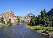
The Mineral County is a county in the state of Colorado of the United States . The county was named after the many valuable minerals found in the mountains and in the streams of this area. Mineral County is mountainous with the Rio Grande flowing through it and is one of the most sparsely populated counties in Colorado.
The county seat is Creede , the only town in the county with about 300 inhabitants. It is located on "Willow Creek", which flows three kilometers south into the Rio Grande. Creede was named after prospector Nicholas C. Creede ( 1843-1897 ), who discovered a large silver mine there in 1891. Creede, born as "William Harvey", had renamed itself in the 1870s. The mineral Creedite was discovered near Creede in 1915 and named after the place.
Despite its name, Spar City has never been a city and consists only of an unpaved road southwest of Creede and a few houses that are mostly only inhabited in summer.
Creede is on National Road 149. The next town from Creede to the southeast is the only slightly larger South Fork in Rio Grande County, 35 kilometers away . There it joins National Road 160 further east to Del Norte and south-west through the uninhabited southern half of the county. There are no direct north-south connecting roads within the county.
The entire county belongs to national parks, mostly to the Rio Grande National Forest , in the southwest also to the adjacent San Juan National Forest .
At the time of the height of the silver mining boom in 1891, Creede briefly had about 10,000 inhabitants. At that time, the county was accessible by rail through the Denver and Rio Grande Western Railroad , which had built a branch line from Alamosa via South Fork and Creede to North Creede .
Adjacent counties
- Saguache County - in the northeast
- Rio Grande County - to the east
- Archuleta County - in the south
- Hinsdale County - to the west
Demographic data
| growth of population | |||
|---|---|---|---|
| Census | Residents | ± in% | |
| 1900 | 1913 | - | |
| 1910 | 1239 | -35.2% | |
| 1920 | 779 | -37.1% | |
| 1930 | 640 | -17.8% | |
| 1940 | 975 | 52.3% | |
| 1950 | 698 | -28.4% | |
| 1960 | 424 | -39.3% | |
| 1970 | 786 | 85.4% | |
| 1980 | 804 | 2.3% | |
| 1990 | 558 | -30.6% | |
| 2000 | 831 | 48.9% | |
| 2010 | 712 | -14.3% | |
| 1900-1990
2000 2010 |
|||
As of the 2000 census , the county had 831 people. There were 377 households and 251 families. The population density was 0.1 inhabitants per square kilometer. The racial the population was composed of 96.87 percent white, 0.84 percent Native American and 0.12 percent from other ethnic groups; 2.17 percent were descended from two or more races. 2.05 percent of the total population were Hispanic or Latino of any race.
Of the 377 households, 22.3 percent had children and young people under the age of 18 living with them. 57.0 percent were married couples living together, 5.8 percent were single mothers. 33.4 percent were not families. 28.1 percent were single households and 9.8 percent had people aged 65 or over. The average household size was 2.20 and the average family size was 2.70 people.
For the entire county, the population was composed of 20.5 percent of residents under 18 years of age, 4.7 percent between 18 and 24 years of age, 24.8 percent between 25 and 44 years of age, 32.7 percent between 45 and 64 years of age 17.3 percent were 65 years of age or over. The median age was 45 years. For every 100 females there were 104.2 males, and for every 100 females aged 18 and over there were 99.1 males.
The median income for a household in the 34,844 USD , and the median income for a family was 40,833 USD. Males had a median income of $ 28,750 versus $ 19,375 for females. The per capita income was $ 24,475. 10.2 percent of the population and 9.3 percent of families are below the poverty line. These included 18.7 percent of the population under the age of 18 and 10.6 percent of the population aged 65 and over.
Individual evidence
- ↑ GNIS-ID: 198155. Retrieved on February 22, 2011 (English).
- ^ History - About Creede at www.creede.com
- ↑ Extract from Census.gov . Retrieved February 28, 2011
- ↑ Excerpt from factfinder.census.gov.Retrieved February 28, 2011
- ↑ Excerpt from census.gov ( Memento of the original from July 14, 2011 on WebCite ) Info: The archive link was automatically inserted and not yet checked. Please check the original and archive link according to the instructions and then remove this notice. Retrieved March 31, 2012
- ^ Mineral County, Colorado , 2000 census data sheet at factfinder.census.gov .
Web links
Coordinates: 37 ° 41 ′ N , 106 ° 56 ′ W


