
Mnichowo (Reszel)
| Mnichowo | |||
|---|---|---|---|

|
|
||
| Basic data | |||
| State : | Poland | ||
| Voivodeship : | Warmia-Masuria | ||
| Powiat : | Kętrzyn | ||
| Gmina : | Reszel | ||
| Geographic location : | 54 ° 2 ' N , 21 ° 7' E | ||
| Residents : | 172 (2011) | ||
| Postal code : | 11-440 | ||
| Telephone code : | (+48) 89 | ||
| License plate : | NKE | ||
| Economy and Transport | |||
| Street : | Ext. 593 : Miłakowo - Dobre Miasto - Jeziorany - Lutry - Zawidy ↔ Robawy (- Reszel ) | ||
| Ext . 596 : Biskupiec - Kabiny - Samławki → Mnichowo | |||
| Reszel - Grodzki Młyn → Mnichowo | |||
| Rail route : | no rail connection | ||
| Next international airport : | Danzig | ||
| Administration (as of 2015) | |||
| Mayor : | Andrzej Pikulski | ||

Mnichowo ( German Groß Mönsdorf ) is a village in Poland in the Warmian-Masurian Voivodeship . It forms a Schulzenamt ( Polish Sołectwo ) in the urban and rural community Reszel (Rößel) , Powiat Kętrzyński ( Rastenburg district ).
Geographical location
Mnichowo is in northeastern Poland, about 35 kilometers south of the Polish state border with the Russian Kaliningrad Oblast . Two kilometers northeast is the former district town of Rößel ( Polish Reszel ), and 15 kilometers northeast is today's district metropolis Kętrzyn ( German Rastenburg ).
history
Today's Mnichowo was created in 1368 as Hohenborn . The name changed to Münchsdorf in the 18th century , and from the 19th century the place was called Groß Mönsdorf . In 1785 Mönsdorf was a royal village with a mill called the "Burgmühle" and a brick factory - with 36 fireplaces.
On March 15, 1823, four people were attacked by a rabid wolf in Mönsdorf , two of whom died soon after as a result of their injuries.
Due to the provisions of the Versailles Treaty , the population voted in the referendums in East and West Prussia on July 11, 1920 on whether they would continue to belong to East Prussia (and thus Germany) or join Poland. In Groß Mönsdorf, 280 residents voted to remain with East Prussia, Poland did not receive any votes.
From 1874 to 1945 Groß Mönsdorf with the localities Burgmühle (Polish: Grodzki Młyn ) and Klein Mnichowo was incorporated into the district of Soweiden (Polish: Zawidy ) in the district of Rößel in the administrative district of Königsberg (from 1905: administrative district of Allenstein ) in the Prussian province of East Prussia .
In January 1945 the Red Army took the area and as a result of the war the village was placed under Polish administration under the name of Mnichowo . On January 1, 1955, Mnichowo became the seat of a Gromada with an area of 3,307 hectares and 948 inhabitants. Just two years later the Gromada was dissolved again and the village part of the Gromada Reszel. After the dissolution of the Gromadas, Mnichowo became the seat of a Schulzenamt in the municipality ( Gmina ) Reszel (Rößel) . The localities of Biel (Weißensee) , Czarnowiec (Schwarzenberg) and Grodzki Młyn (Burgmühle) belonged to the Schulzenamt .
Population numbers
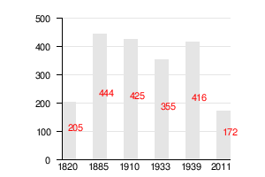
In 1783 there were 36 residential buildings in the village, in 1820 there were 32. In 1820 the village also had an outbuilding with three buildings and 23 residents. The following shows the population development graphically.
church
Until 1945, Groß Mönsdorf was parish in the Protestant church Rößel in the church province of East Prussia of the Church of the Old Prussian Union and in the Catholic St. Peter and Paul Church in Rößel in the then diocese of Ermland . Today Minchowo belongs on the Protestant side to the parish Kętrzyn in the diocese of Masuria of the Evangelical-Augsburg Church in Poland , on the Catholic side it still belongs to the parish in Reszel , which is in the current Archdiocese of Warmia .
traffic
Voivodship road 593 runs through Mnichowo . This opens west to about 15 kilometers at Lutry (Kaiserslautern) in the country Straße 57 . In an easterly direction, it meets at Robawy (Robawen , 1938 to 1945 Robaben ) on Voivodship Road 590 , which leads to Reszel. After Reszel - via Grodzki Młyn (castle mill) - there is also a side road leading north from Mnichowo.
There is no connection to rail traffic .
The geographically closest international airport is Kaliningrad Airport , which is located about 100 kilometers north on Russian territory and thus outside the European Union . The nearest international airport on Polish territory is Lech Walesa Airport in Gdansk, about 180 kilometers to the west .
literature
- Tadeusz Swat: Dzieje wsi . In: Aniela Bałanda and others: Kętrzyn. Z dziejów miasta i okolic . Pojezierze, Olsztyn 1978, p. 207 ( Seria monografii miast Warmii i Mazur ).
Individual evidence
- ↑ Polish Postal Code Directory 2013, p. 789
- ↑ Wykaz Sołtysów w Gminie Reszel , Wrota Warmii i Mazur - Regionalny portal informacyjny, accessed on June 7, 2016
- ^ Dietrich Lange, Geographical Register of Places East Prussia (2005): Groß Mönsdorf
- ↑ a b Groß Mönsdorf at GenWiki
- ↑ Kossendei: Report on the last hours and the death of the compatriot in the Diocese of Warmia in East Prussia, J. Fuge, who was seriously injured by a great Wolfe and who died of water aversion as a result of these injuries . In: Prussian provincial sheets . Volume 1, Koenigsberg 1829, pp. 449-462.
- ↑ Herbert Marzian , Csaba Kenez : self-determination for East Germany. Documentation on the 50th anniversary of the East and West Prussian referendum on July 11, 1920. Editor: Göttinger Arbeitskreis , 1970, p. 108
- ↑ Rolf Jehke, District Soweiden
- ↑ Swat 1978, p. 207, for 2011: Wieś Mnichowo w liczbach

City: Reszel (Rößel)
Villages and school offices : Bezławki (Bäslack) | Czarnowiec (Schwarzenberg) | Dębnik (Damerauwald) | Klewno (Klawsdorf) | Kocibórz (Kattmedien) | Leginy (Legien) | Łężany (Loszainen / Loßainen) | Mnichowo (Groß Mönsdorf) | Pieckowo (Pötschendorf) | Pilec (Pülz) | Plenowo (Plönhöfen) | Ramty (Ramten) | Robawy (Robawen / Robaben) | Siemki ( Scharfs ) | Święta Lipka (Holy Linden Tree) | Tolniki Małe (Tollnigk) | Widryny (Widrinnen) | Wola (Dürwangen) | Worpławki (Worplack) | Zawidy (Soweiden)
Other localities: Bertyny (Bertienen) | Bezławecki Dwór (Bäslackshof) | Biel (Weissensee) | Grodzki Młyn (Castle Mill) | Grzybowo (Mirror Korschen) | Kępa Tolnicka (Atkamp) | Łabędziewo (Labendzowo / Schwanau) | Lipowa Góra (Lindenberg) | Mała Bertynówka | Mojkowo (Annahof) | Niewodnica (Fischbach) | Pasterzewo (Pastern) | Pudwągi (Posewangen) | Śpigiel (mirror) | Śpiglówka (Spieglowen / Spiegelswalde) | Staniewo (Ottoswalde) | Stąpławki (Nobleman Stumplack) | Wanguty (Wangotten) | Wólka Pilecka ( Stechernsruh ) | Wólka Ryńska (Rheindorfshof)