
Mett-Oberschlatt
| Mett-Oberschlatt | ||
|---|---|---|
 |
||
| State : |
|
|
| Canton : |
|
|
| District : | Frauenfeld | |
| Political community : | Schlatt | |
| Postal code : | 8252 | |
| former BFS no. : | 4532 | |
| Coordinates : | 694 388 / 279 339 | |
| Height : | 448 m above sea level M. | |
| Residents: | 306 (December 31, 2010) | |
 Oberschlatt with bell tower |
||
| map | ||
|
||

Mett-Oberschlatt was from 1816 to 1998 a local parish of the former municipality of Basadingen in the Diessenhofen district of the canton of Thurgau in Switzerland . The local community was made up of the districts Mettschlatt, Oberschlatt and Fallentor, which are not far from the Frauenfeld – Schaffhausen road on the eastern slope of the Kohlfirst .
Since January 1st, 1999, Mett-Oberschlatt has formed the political municipality Schlatt TG in the Frauenfeld district together with Unterschlatt .
history

Schlatt was first mentioned in 858 as Slate . In the Middle Ages, the Kyburg - Habsburg Bailiwick of Diessenhofen had jurisdiction over Mett-Oberschlatt. In the 15th century this was taken over by the city of Diessenhofen and exercised until 1798. Before 858 the landowner was the monastery of St. Gallen , from 858 the monastery Rheinau , from the 13th century the monastery of St. Katharinental among others . From 1803 to 1816 the local community Mett-Oberschlatt was a part of the municipal community Diessenhofen.
The St. Niklaus Chapel in Mett-Oberschlatt, which existed from 1316 to 1812, belonged to Stammheim . The independent Schlatt parish was created through the Reformation, which took place in 1529 . This waived a pastor until 1769 and was provided from the end of the 16th century from Basadingen and from 1625 to 1631 from Diessenhofen.
The farming village of Mett-Oberschlatt carried out a property improvement from 1969 . From the 1980s onwards, a number of service companies emerged.
coat of arms

Blazon : Diagonally divided by yellow with a striding red lion and by red with a yellow sickle .
The lion probably refers to the Kiburger, the sickle stands for the agricultural character of the community. The colors symbolize the earlier belonging to the Vogtei and Hochgericht Diessenhofen.
population
| year | 1800 | 1850 | 1870 | 1900 | 1950 | 1990 | 2000 | 2010 |
| Local parish | 203 | 287 | 332 | 257 | 317 | 326 | ||
| Locality | 247 | 306 | ||||||
| source | ||||||||
In 2018 Mettschlatt had 301 and Oberschlatt 148 inhabitants.
Attractions

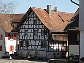
In the two villages of Mett- and Oberschlatt, Dreisässen houses from the 19th century still predominate. The walls of the living area are usually made of half-timbering , which have remarkable symmetries and motifs in the direction of the transoms.
The Türmli, built in 1814, stands on a hill east of the village. In its place was the St. Niklaus Chapel, which was demolished at the same time and was first mentioned in 1316. The two bells from the chapel hang in the roof stalls of the square tower with its original hipped roof.
The bell tower and the farmhouse at Hauptstrasse 17, both in Oberschlatt, are included in the list of cultural assets in Schlatt TG .
Farmhouse Hauptstrasse 17

Old school house

Mett-Oberschlatt


literature
- Erich Trösch: Mett-Oberschlatt. In: Historical Lexicon of Switzerland .
This article is largely based on the entry in the Historisches Lexikon der Schweiz (HLS), which, according to the HLS's usage information, is licensed under the Creative Commons - Attribution - Distribution under the same conditions 4.0 International (CC BY-SA 4.0) license .
Individual evidence
- ↑ a b List of localities and settlements. Canton of Thurgau, 2012 edition. On the website of the Statistical Office of the Canton of Thurgau (PDF; 3.4 MB), accessed on May 11, 2020.
- ↑ Swiss land use statistics. Completed on July 1, 1912. Published by the Federal Statistical Bureau. ( Memento from April 12, 2016 in the Internet Archive )
- ^ Community merger in the canton of Thurgau: Schlatt. On the website of the Swiss Coats of Arms and Flags Foundation, accessed on December 20, 2019
- ^ Municipal coat of arms . On the website of the State Archives of the Canton of Thurgau, accessed on December 8, 2019
- ↑ Locations and Settlements Directory. Canton of Thurgau, 2005 edition . On the website of the Statistical Office of the Canton of Thurgau (PDF; 1.7 MB), accessed on April 28, 2020.
- ↑ List of settlements. Canton of Thurgau, edition 2019 . On the website of the Statistical Office of the Canton of Thurgau (Excel table; 0.2 MB), accessed on May 10, 2020.
- ↑ a b story. On the website of the municipality of Schlatt (TG), accessed on December 20, 2019
Remarks
- ↑ without outside courtyards
Basadingen-Schlattingen | Berlingen | Diessenhofen | Eschenz | Felben-Wellhausen | Frauenfeld | Gachnang | Herdern | Homburg | Hüttlingen | Hüttwilen | Mammers | Matzingen | Muellheim | Nine-shape | Pfyn | Schlatt | Steckborn | Stettfurt | Thundorf | Uesslingen book | Wagenhausen | Warth-Weiningen
Former municipalities: Basadingen | Book near Frauenfeld | Dettighofen | Eschikofen | Fahrhof | Felben | Gerlikon | Gündelhart-Hörhausen | Harenwilen | Herten | Horgenbach | Huben | Islikon | Kaltenbach | Kefikon | Kurzdorf | Langdorf | Langenhart | Lance neunforn | Lustdorf | Mett-Oberschlatt | Mettendorf | Niederneunforn | Niederwil | Walnut trees | Oberneunforn | Oberwil | Rheinklingen | Salen-Reutenen | Schlattingen | Uerschhausen | Uesslingen | Subdivision | Warth | Weiningen | Wellhausen | Wetzikon | Wilen bei Neunforn | Willisdorf
Canton of Thurgau | Districts of the Canton of Thurgau | Municipalities of the Canton of Thurgau