
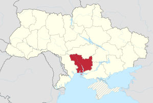
Mykolaiv Oblast
| Mykolaiv Oblast | |
|---|---|
|
Миколаївська область
Mykolaivska oblast Николаевская область Nikolayevskaya oblast |
|

|

|
| Basic data | |
| Oblast center : | Mykolaiv (Nikolayev) |
| Official languages : | Ukrainian , Russian |
| Residents : | 1,168,400 (2014) |
| Population density : | 47.5 inhabitants per km² |
| in cities : | 66.6% |
| Area : | 24,598 km² |
| KOATUU : | 4800000000 |
| License plate : | BE, HE |
| Administrative division | |
| Rajons : | 19th |
| Cities : | 10 |
| managed by Oblast: | 5 |
| administered by Rajon: | 5 |
| Stadtrajone : | 4th |
| Urban-type settlements : | 17th |
| Villages: | 820 |
| Settlements : | 74 |
| Contact | |
| Address: | вул. Адміральська 22 54009 м. Миколаїв |
| Website: | Official website |
| map | |
 .svg) |
|
| Statistical information | |
The Mykolaiv Oblast ( Ukrainian Миколаївська область Mykolaivska oblast ; Russian Николаевская область Nikolajewkaja oblast ) is one of 25 administrative units ( oblasts ) in southern Ukraine with access to the Black Sea , which marks the southern border. It has around 1.17 million inhabitants (2014).
In the West, Mykolaiv Oblast borders the Odessa Oblast and the north by the Oblast Kirovohrad . In the northeast of the oblast is the Dnipropetrovsk Oblast , in the southeast of the Kherson Oblast .
The southern Bug flows through the oblast .
history
The oblast was created on September 22, 1937 on the basis of the decree of the Central Executive Committee of the USSR on the unbundling of the Oblasts of Kharkov , Kiev , Vinnitsa and Odessa . The Odessa Oblast was divided into the Odessa Oblast and Nikolajew Oblast.
The new oblast included three cities under Oblast administration - Nikolayev, Kherson and Kirov, and 38 districts, including 29 districts from Odessa Oblast and 9 from Dnepropetrovsk Oblast .
On January 10, 1939, the Kirovohrad Oblast was spun off from the Oblast Association with the city of Kirovohrad and 13 Rajonen. During the occupation by German and Romanian troops in the Second World War from the summer of 1941, the area was divided between the Romanian Transnistria and the German Reichskommissariat Ukraine (General District Nikolayev).
After the area was recaptured by the Red Army , the Kherson Oblast was formed on March 30, 1944 and the city of Kherson and 13 districts were separated from the Mykolaiv Oblast, but 5 districts were added from the Odessa Oblast. On February 17, 1954, another 5 Rajons from the area of Odessa Oblast were added to the Oblast, in the following period the Rajons areas were changed several times until 1966. On March 3, 1988, the villages of Bilousove (Білоусове) and Tokarewe (Токареве) finally changed their affiliation to Kherson Oblast.
Biggest cities
The capital of the oblast is the city of the same name, Mykolaiv, on the Southern Bug .
| city | Ukrainian name | Russian name | Resident January 1, 2006 |
|---|---|---|---|
| Mykolaiv | Миколаїв | Николаев | 508.350 |
| Pervomaysk | Первомайськ | Первомайск | 67,852 |
| Voznesensk | Вознесенськ | Вознесенск | 39.097 |
| Yuzhnoukrajinsk | Южноукраїнськ | Жноукраинск | 39,075 |
| Novyj Boo | Новий Буг | Новый Буг | 15,795 |
| Ochakiv | Очаків | Очаков | 15,281 |
| Snihuriwka | Снігурівка | Снигирёвка | 14,443 |
| Nowa Odessa | Нова Одеса | Новая Одесса | 13,469 |
| Bashtanka | Баштанка | Баштанка | 12,712 |
See also: List of cities in Mykolaiv Oblast
Administrative division
The Mykolaiv Oblast is administratively divided into 19 Rajons and 5 cities directly under the Oblast administration. These are the cities of Voznesensk , Ochakiv , Pervomajsk , Juschnoukrajinsk and the eponymous administrative center of the oblast, the city of Mykolaiv .
Mykolaiv Oblast Rajons and their administrative centers

Demographics
| year | 1989 | 1990 | 1995 | 1998 | 2001 | 2005 | 2008 | 2012 | 2014 |
|---|---|---|---|---|---|---|---|---|---|
| Residents | 1,330,600 | 1,336,200 | 1,352,100 | 1,320,200 | 1,279,000 | 1,229,522 | 1,203,560 | 1,178,223 | 1,168,400 |
| nationality | Residents | 1989 (%) | 2001 (%) | Change (%) |
|---|---|---|---|---|
| Ukrainians | 1,034,500 | 75.6 | 81.9 | + 3.1% |
| Russians | 177,500 | 19.4 | 14.1 | −31.2% |
| Moldovans | 13,100 | 1.3 | 1.0 | −21.0% |
| Belarusians | 8,300 | 1.1 | 0.7 | −42.2% |
| Bulgarians | 5,600 | 0.5 | 0.4 | −20.5% |
| Armenians | 4,200 | 0.1 | 0.3 | +140% |
| Jews | 3,200 | 0.9 | 0.3 | −72.6% |
| native language | 1989 (%) | 2001 (%) |
|---|---|---|
| Ukrainian | 64.2 | 69.2 |
| Russian | 33.8 | 29.3 |
Web links
Individual evidence
- ↑ http://www.ukrstat.gov.ua/
- ↑ Президія Верховної Ради УРСР; Указ від 03.03.1988 № 5513-XI Про передачу Білоусівської сільради Березнегуватського району скиколаївськото кірезнегуватського району соколаївськото кораласвсосото киколаївсьсото киколаївсосото киколаївськото киколаївськото киколаївсосото киколаївсьсото киколаївськото киколаївсьсото киколаївското
- ↑ http://www.ukrcensus.gov.ua/eng/
- ↑ http://www.ukrstat.gov.ua/
- ↑ http://2001.ukrcensus.gov.ua/eng/results/general/nationality/
- ↑ http://2001.ukrcensus.gov.ua/eng/results/general/language/Mykolaiv/
Oblast : Kharkiv | Kherson | Khmelnytskyi | Dnepropetrovsk | Donetsk | Ivano-Frankivsk | Kiev | Kirovohrad | Luhansk | Lviv | Mykolaiv | Odessa | Poltava | Rivne | Zaporizhia | Zhytomyr | Sumy | Ternopil | Transcarpathia | Cherkassy | Chernihiv | Chernivtsi | Wolyn | Vinnytsia
Cities with subject status: City of Kiev | City of Sevastopol 1
Autonomous Republic: Crimea 1
1 areas annexed by Russia
Bashtanka | Yuzhnoukrajinsk | Mykolaiv | Pervomaysk | Nowa Odessa | Novyj Boo | Ochakiv | Snihuriwka | Voznesensk
Urban-type settlements
Arbusynka |
Berezanka |
Beresnehuwate |
Bratske |
Domanivka |
Jelanez |
Kazanka |
Kostyantynivka |
Krywe Osero |
Oleksandrivka |
Olschanske |
Pervomayske |
Pidhorodna |
Tokarivka |
Wesselynowe |
Woskressenske |
Vradiyivka