
Querenburg
|
district of Bochum |
|
|---|---|
 |
|
| Coordinates | 51 ° 27 '11 " N , 7 ° 16' 6" E |
| height | 127 m above sea level NHN |
| surface | 9.11 km² |
| Residents | 20,958 (Dec. 31, 2017) |
| Population density | 2301 inhabitants / km² |
| Incorporation | Aug 1, 1929 |
| Post Code | 44799 and 44801 |
| structure | |
| district | south |
| Markings |
Querenburg, Hustadt, Steinkuhl |
| Source: | |
Querenburg is a south-eastern district of Bochum with around 21,000 inhabitants and is the location of both the Ruhr University Bochum and the Bochum University of Applied Sciences . Until 1929 Querenburg was an independent municipality in the Bochum district .
history
Querenburg was a Franconian clan settlement from 790 and consisted of the free farms Frielinghausen, Thöne, Schulte Overberg and Schulte Kleinherbede . During the construction of the Ruhr University, there were also traces of settlement which, when excavated by Karl Brandt , Herne, began on March 31, 1964, to around 4000 BC. Dated.
The name Quernberga appears in the Hebeblisten of Werden monastery from 890. It is mentioned as Querenberg around 1150 and in the treasury of Grafschaft Mark from 1486 as Querenberg . In the “Prothocollum undt Aufnahmb der Feuerstädten im Mitelambt Bochumb” from 1664, Quernburgh is mentioned . At that time, about 215 residents lived there. The other name for the community was Vrilinkhuisen , later Frielinghausen .
An iron hammer was operating on the border with Laer as early as 1752 . The region experienced an upswing when the new Chaussee from Bochum to Witten became accessible in 1791 . From August 3, 1898, the tram ran from Bochum to Laer, and from 1901 to the city limits of Witten.
In Querenburg many mines emerged, including mine Eulenbaum , mine Klosterbusch and mine Mansfeld . In the Kalwes forest there was also an explosives depot embedded in the rock . This exploded on the morning of January 13, 1914. In the explosion, some people and horses were killed. a. hung from the tops of the trees around them.
The workers' settlement on Lennershofstrasse was initiated in 1920 by August Bahrenberg . On August 1, 1929 Querenburg was incorporated into Bochum . At that time it had 2894 inhabitants. In April 1933, the Social Democratic community leader Bahrenberg was arrested by the SA and tortured in the former Gibraltar colliery on the Ruhr . He died a few weeks later.
Querenburg was still largely agricultural when a major structural change took place from 1962 : The Ruhr University Bochum and the Botanical Garden , the Adam Opel GmbH plant Bochum I , Universitätsstraße with the U35 light rail line (formerly tram line 5, from 1980 ( VRR - Foundation): 305 and later 306) and the city motorway (Opel-Ring), the A 43 motorway (released in 1971), the university framework town of Hustadt , the university center , the Bochum University of Applied Sciences and the technology park (on the grounds of the Mansfeld colliery ) the landscape almost completely. When the Ruhr-Universität Bochum started operations in 1965 and professors were recruited, the so-called “professors' quarter” was built for them; it consists of many bungalows with large gardens.
Already at the beginning of the 19th century the Oelbach in the east of Querenburg was canalized, which was supposed to discharge the mine wastewater from Langendreer . The Oelbachtal sewage treatment plant from 1922 was expanded several times and supplemented with two modern digested sludge silos at the end of the 1990s . It cleans the wastewater from Laer, Steinkuhl, Querenburg and over the Oelbach coming from Werne and Langendreer. The area around Lake Kemnader, which was completed in 1979, is a destination for local recreation.
population
On December 31, 2019, 21,284 people lived in Querenburg.
Structural data of the population in Querenburg:
- Minor quota: 15.4% [Bochum average: 14.6% (2019)]
- Old age quota (60 years and older): 20.1% [Bochum average 28.3% (2019)]
- Proportion of foreigners: 32.4% [Bochum average 14.4% (2019)]
- Unemployment rate: 6.8% [Bochum average 8.9% (2017)]
gallery

View from the nature reserve on the Kalwes to the Bochum University of Applied Sciences
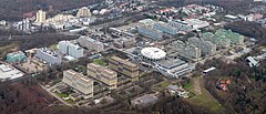
Ruhr-University Bochum
Uni Center

Street "Auf dem Backenberg"


See also
literature
- Curt HF Gaertner: Querenburg, as it was, as it is ; Brockmeyer, 1976, ISBN 3-921543-53-3
- Günther Höfken: Bochumer Heimatbuch , Volume 2; 1927
- Franz Darpe : History of the City of Bochum , 1888–1894
- Lutz Heidemann : Group-specific living behavior - results of an architectural-sociological study of the Hustadt in Bochum-Querenburg. Dissertation, Verlag der Scharioth'schen Buchhandl., Essen 1978
- Michael Fehr , Diethelm Koch (eds.): Reconstruction of the city: Example of Bochum. Museum Bochum, 1975
Web links
Individual evidence
- ↑ Bochum districts compact 2018 (page 69). City of Bochum Department for Social Affairs, Youth and Health, accessed on July 9, 2019 .
- ↑ The population figures are given according to statistical districts and not according to the districts, the figures for this are in the article population development of Bochum
- ↑ Stephanie Reekers: The regional development of the districts and communities of Westphalia 1817-1967 . Aschendorff, Münster Westfalen 1977, ISBN 3-402-05875-8 , p. 273 .

Altenbochum with Steinkuhl | Mountains | Dahlhausen with Oberdahlhausen | Eppendorf with Castel Sant'Angelo and Heath | Gerthe | Grumbles | Günnigfeld | Hamme with gold hammer (with Maar bridge ), Hundhamme and Stahlhausen | Harpen with Kirchharpen, Kornharpen , Rosenberg and Voede branch | Hiltrop | Hofstede with Marmelshagen | Höntrop | Hordel | Downtown | Laer | Langendreer with Kaltehardt , Langendreerholz and Ümmingen | Leithe | Linden | Munscheid | Querenburg with Hustadt and Steinkuhl | Riemke | Sevinghausen | Stiepel with Brockhausen , Haar and Schrick | Wattenscheid center with Südfeldmark | Weitmar with Bärendorf , Mark , Mitte and Sundern | Werne | Westenfeld | Wiemelhausen with Brenschede , Kirchviertel and Ehrenfeld