
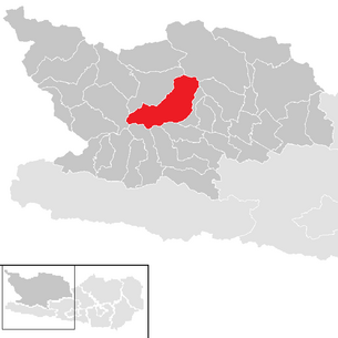
Reisseck (municipality)
|
Reisseck
|
||
|---|---|---|
| coat of arms | Austria map | |
 |
|
|
| Basic data | ||
| Country: | Austria | |
| State : | Carinthia | |
| Political District : | Spittal an der Drau | |
| License plate : | SP | |
| Main town : | Kolbnitz | |
| Surface: | 139.71 km² | |
| Coordinates : | 46 ° 53 ′ N , 13 ° 18 ′ E | |
| Height : | 613 m above sea level A. | |
| Residents : | 2,101 (January 1, 2020) | |
| Population density : | 15 inhabitants per km² | |
| Postcodes : | 9815, 9816 | |
| Area code : | 0 47 83 | |
| Community code : | 2 06 44 | |
| NUTS region | AT212 | |
| Address of the municipal administration: |
Unterkolbnitz 50 9815 Kolbnitz |
|
| Website: | ||
| politics | ||
| Mayor : | Kurt Felicetti ( SPÖ ) | |
|
Municipal Council : ( 2015 ) (19 members) |
||
| Location of Reisseck in the Spittal an der Drau district | ||
  |
||
| Source: Municipal data from Statistics Austria | ||

Reißeck is a municipality with 2101 inhabitants (as of January 1, 2020) in the Spittal an der Drau district in Carinthia . The name of the municipality with the main town Kolbnitz, which was formed in 1973, is the highest point in the municipality, the Reißeck ( 2965 m ).
geography
Geographical location
The community is located in the lower Mölltal and is bordered by the Reisseckgruppe in the north and the Kreuzeckgruppe in the south. Dominant geographical features are the Möll , the Tauernbahn , the Mölltal Straße , the Danielsberg and the Rottau reservoir .
Community structure
The community is divided into four cadastral communities , which comprise the following 17 localities (population in brackets as of January 1, 2020):
Kolbnitz part of the municipality Part of the municipality Penk Part of the municipality Teuchl KG Kolbnitz KG Zandlach KG Penk KG Teuchl Lower Kolbnitz (377) Zandlach (244) Penk (275) Teuchl (76) Oberkolbnitz (305) Napplach (231) Drafts (42) Polan (118) Gappen (113) Price Village (86) Zwenberg (47) Sandbichl (53) Litzldorf (52) Mitterberg (51) Moss (3) Hattelberg (18) Rottau (10)

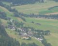
Oberkolbnitz , Unterkolbnitz and Zandlach vom Danielsberg
Litzldorf from Zwenberg

Napplach from Zwenberg

Penk vom Zwenberg
_seen_from_Danielsberg.jpg)


Neighboring communities
| Obervellach | Malta | Trebesing |
| barn |
.svg)
|
|
| Sachsenburg / Steinfeld / Greifenburg | Mühldorf |
Directly accessible neighboring communities in the Mölltal are Obervellach and Mühldorf . The other communities only border on the Reisseck community in the mountains.
history
The Kolbnitz parish was constituted for the first time in 1850, and was attached to Obervellach 15 years later , but became independent again in 1876 after a further eleven years. In 1913, the Mühldorf cadastral community split off from the original community area and became its own local community.
In the course of the municipality reform in 1973 in Carinthia, the municipality of Reißeck was founded from the three municipalities of Kolbnitz, Mühldorf and Penk. In 1992 the municipality of Mühldorf regained its independence after a referendum. Since then, the tenth largest municipality in Carinthia with an area of 139.83 km² has existed in its current size.
population
|
|
||||||||||||||||||||||||||||||||||||
| Population development 1869 - 2001 | |||||||||||||||||||||||||||||||||||||
According to Statistics Austria, the community had 2,331 inhabitants in 2011. The number of community residents has increased by 31% since 1869. This increase is below the average of the population development of the federal state of Carinthia (+ 77%).
At the time of the 2001 census, 94.6% of the population had Austrian citizenship, while the largest proportion of the foreign population were German (1.5%) and Croatian (1.0%) citizens.
The vast majority of the parish population is Roman Catholic (82.1%). The next largest religious community ( Protestant ) has a population of 7.2%. Community citizens without religious affiliation come to 6.9%.
Culture and sights
- The branch church of St. George on Danielsberg on Danielsberg
- The Kolbnitz parish church in Kolbnitz, first mentioned in a document in 1124, is a late Gothic, later Baroque redesigned church building with a two-aisled nave and a mighty north tower with a pointed gable helmet.
- Chapel Maria am Sandbichl in Oberkolbnitz is a small, single-nave wooden structure that was built in 1716.
- The parish church of Penk at the southern end of Penk was first mentioned in a document in 1233.
- The Teuchl parish church in Teuchl is a small, baroque hall church. It was built in 1685 and consecrated in 1758.
- The Marienkapelle Napplach is a small Marienkapelle built in 1847 in Napplach.
- The Reisseck-Kreuzeck power plant group and the Malta power plants
- Mölltheuer castle ruins north of Penk
- Mills on the Rieggenbach
- Kreuzeckbahn
- Reisseckbahn
- Natural monuments
- Danielsberg , an old Celtic place of worship
- Bernitzbach waterfall
politics
Municipal council
The Reißeck municipal council has 19 members and has been composed as follows since the 2015 municipal council election :
The directly elected mayor has been Kurt Felicetti (SPÖ) since the runoff election on June 3, 2012. Previously, Gerd Pichler (FLR), who had been in office since 1997, had resigned for health reasons.
coat of arms
The right to use a coat of arms was granted to the former Kolbnitz municipality on January 18, 1968. With the establishment of the municipality of Reißeck in 1973, the coat of arms was transferred to it.
The coat of arms is designed as a split shield and shows in the front half on a green background a golden Hercules with lion skin and club, who stands on the silver stylized Danielsberg. It symbolizes a glorious past, in which a Roman temple is said to have stood on the top of the Danielsberg. Half a Pelton wheel can be seen at the gap in the rear half of the shield of the coat of arms . It was chosen as a symbol for the electricity industry that predominates today ( Malta power plants and the Reißeck-Kreuzeck power plant group ).
The municipality's flag is red-yellow-green with an incorporated coat of arms.
Town twinning
- Koenigsbronn , Germany
- Thalmässing , Germany
Web links
- 20644 - Reißeck (municipality). Community data, Statistics Austria .
Individual evidence
- ↑ Statistics Austria: Population on January 1st, 2020 by locality (area status on January 1st, 2020) , ( CSV )
- ↑ the official coordinate of the place Oberkolbnitz is on the cadastral municipality border Kolbnitz / Zandlach
Bad Kleinkirchheim | Baldramsdorf | Berg im Drautal | Dellach im Drautal | Flattach | Gmünd in Carinthia | Greifenburg | Großkirchheim | Heiligenblut am Großglockner | Irschen | Kleblach-Lind | Krems in Carinthia | Lendorf | Lurnfeld | Mallnitz | Malta | Millstatt am See | Mörtschach | Mühldorf | Oberdrauburg | Obervellach | Radenthein | Rangersdorf | Reisseck | Rennweg am Katschberg | Sachsenburg | Seeboden am Millstätter See | Spittal an der Drau | Stall | Steinfeld | Trebesing | Weissensee | Winklern
Parts of the municipality: Kolbnitz | Penk | Teuchl
Cadastral communities: Kolbnitz | Penk | Teuchl | Zandlach
Localities: Gappen | Hattelberg | Litzldorf | Mitterberg | Moss | Napplach | Oberkolbnitz | Penk | Polan | Preisdorf | Rottau | Sandbichl | Teuchl | Drafts | Lower Kolbnitz | Zandlach | Zwenberg
Villages: Kohlstatt • Napplach • Oberkolbnitz • Penk • Unterkolbnitz • Zandlach | Rotten: Gappen • Litzldorf • Preisdorf • Rottau | Settlements: Polan • Sandbichl • Tratten | Scattered houses: Hattelberg • Mittelberg • Moos • Roßwiese • Teuchl • Zwenberg | Other locations: Mölltheuer ruins • Zandlacher hut
Counting area: Kolbnitz adTauernbahn | Penk