
Rohr in Lower Bavaria
| coat of arms | Germany map | |
|---|---|---|

|
Coordinates: 48 ° 46 ' N , 11 ° 58' E |
|
| Basic data | ||
| State : | Bavaria | |
| Administrative region : | Lower Bavaria | |
| County : | Kelheim | |
| Height : | 426 m above sea level NHN | |
| Area : | 54.17 km 2 | |
| Residents: | 3350 (Dec. 31, 2019) | |
| Population density : | 62 inhabitants per km 2 | |
| Postal code : | 93352 | |
| Area code : | 08783 | |
| License plate : | KEH, MAY , PAR , RID, ROL | |
| Community key : | 09 2 73 165 | |
| Market structure: | 45 districts | |
Market administration address : |
Marienplatz 1 93352 Rohr i.NB |
|
| Website : | ||
| Mayor : | Birgit Steinsdorfer ( CSU ) | |
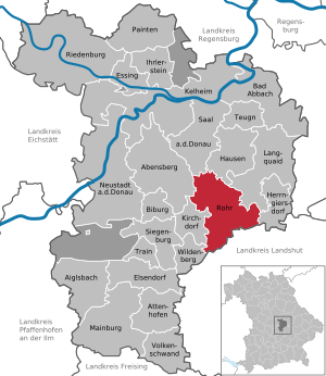
| Location of the Rohr i.NB market in the Kelheim district | ||
  |
||

Rohr in Niederbayern (officially: Rohr i.NB ) is a market in the Hallertau in the Lower Bavarian district of Kelheim (Altlandkreis Rottenburg ).

geography
Rohr i.NB is located in the Regensburg planning region.
In addition to the main town, the community consists of the following villages, hamlets and wastelands : Aich, Alzhausen , Asbach, Au, Bachl , Berg, Birka, Graben, Gressau, Grub, Helchenbach , Hirtdorf, Höfel, Högetsing, Kalteneck, Kiefermühle, Kleinthalhof, Kronholzen, Laaber , Laaberberg , Mixmühle, Mordberg, Oberbuch , Obereulenbach , Obergrünbach , Obermondsberg, Oberndorf, Oberrohr, Reichenroith, Sallingberg , Schünsch, Schmiddorf, Schöfthal, See, Stegen, Stocka, Straßenhaus, Thalhof , Thalhof , Untergrünbach, Ursbach, Wallersdorf, Waselsdorf and Weiherhof.
A former part of the municipality was Loretto , formerly also known as the Klause .
history
Until the church is planted
The first soil and grave finds in the area date from around 2000 BC. Around the year 1000, the first descendants of Count Babo probably settled in the region. The oldest documentary mention comes from the year 1097/98.
The Rohr market belonged to the Augustinian canons of Rohr . The place was part of the Electorate of Bavaria , but formed a closed Hofmark , whose seat was the monastery. As part of this Hofmark, Rohr could only exercise a small part of its market rights , which were granted by Emperor Ludwig IV in 1347 . In 1803 the monastery was closed . When the Battle of Abensberg broke out in 1809 , the Austrian Archduke Karl and then the French Emperor Napoléon Bonaparte stayed at the same inn in Rohr on April 18 and 20, respectively.
In the course of the administrative reforms in the Kingdom of Bavaria , today's municipality was created with the municipal edict of 1818 .
Incorporations
On January 1, 1910, the previously independent municipality of Klosterrohr , which until 1875 was known as Rohr, Kloster , was incorporated. On July 1, 1972, Obereulenbach and areas of the dissolved community of Wolferthau were added. Laaberberg followed on January 1, 1974. Helchenbach came on January 1, 1978, areas of the dissolved Offenstetten municipality were added on May 1, 1978.
Population development
In the period from 1988 to 2018, the population increased from 2,982 to 3,323 by 341 inhabitants or 11.4%.
- 1961: 2958 inhabitants
- 1970: 3010 inhabitants
- 1987: 2956 inhabitants
- 1991: 2999 inhabitants
- 1995: 3159 inhabitants
- 2000: 3314 inhabitants
- 2005: 3336 inhabitants
- 2010: 3250 inhabitants
- 2015: 3369 inhabitants
politics

mayor
Birgit Steinsdorfer ( CSU ) has been the mayor since May 2020 .
Market council
The market council with its 16 members was last elected on March 15, 2020 and is composed as follows:
- Christian Social Union (CSU): 6 seats
- Social Democratic Party of Germany (SPD): 1 seat
- Free voters (FW): 4 seats
- Citizen List 2020 (Citizen List 2020): 4 seats
- Alliance 90 / Greens (Greens): 1 seat
Community partnerships
-
 Italy : The partner municipality of Rohr in Lower Bavaria has been the municipality of Castelcucco since 2003 .
Economy and Infrastructure
Economy including agriculture and forestry
In 1998 there were 10 employees in the field of agriculture and forestry, 184 in the manufacturing sector and 55 in the trade and transport sector at the place of work. In other economic sectors, 248 people were employed at the place of work subject to social security contributions. There were a total of 924 employees at the place of residence subject to social security contributions. There were two companies in the manufacturing sector and four in the construction sector. In addition, in 1999 there were 142 agricultural holdings with an agriculturally used area of 3716 ha. Of this, 3308 ha were arable land and 403 ha were permanent green areas.
education
There are the following facilities:
- Benedictus library
- Kindergarten St. Elisabeth
- primary school
- Johannes-Nepomuk-Gymnasium Rohr i.NB.
- Community College
Architectural monuments


- Benedictine Abbey of Rohr Monastery
- Monastery church of the Assumption , built and furnished by the Asam brothers
- Loretto Chapel
Sons and daughters of the church
- Stephan Zirler (around 1520 - 1568), Renaissance composer and court official in the Electoral Palatinate
- August Reitmayr (1802–1874), member of the Frankfurt National Assembly
- Michael Zieglmeier (1874–1959), Senior Mountain Director
- Marianne Hofmann (1938–2012), writer
- Gerd Maier (* 1945), writer and dialect researcher
- Alexander Knörr (* 1947), judge at the Federal Social Court 2002–2012
- Anton Gorbunow (* 1949), long-distance runner
- Michael Birnthaler (* 1963), writer and experience educator
Individual evidence
- ↑ "Data 2" sheet, Statistical Report A1200C 202041 Population of the municipalities, districts and administrative districts 1st quarter 2020 (population based on the 2011 census) ( help ).
- ↑ Markt Rohr i.NB. in the location database of the Bavarian State Library Online . Bavarian State Library
- ↑ Bavarian State Statistical Office (ed.): Official place directory for Bavaria - edited on the basis of the census of September 13, 1950 . Issue 169 of the articles on Bavaria's statistics. Munich 1952, DNB 453660975 , Section II, Sp. 594 ( digitized version ).
- ^ Wilhelm Volkert (ed.): Handbook of Bavarian offices, communities and courts 1799–1980 . CH Beck, Munich 1983, ISBN 3-406-09669-7 , p. 493 .
- ^ Wilhelm Volkert (ed.): Handbook of Bavarian offices, communities and courts 1799–1980 . CH Beck, Munich 1983, ISBN 3-406-09669-7 , p. 563 .
- ^ Federal Statistical Office (ed.): Historical municipality directory for the Federal Republic of Germany. Name, border and key number changes in municipalities, counties and administrative districts from May 27, 1970 to December 31, 1982 . W. Kohlhammer, Stuttgart / Mainz 1983, ISBN 3-17-003263-1 , p. 610 and 611 .
Web links
- Entry on the coat of arms of Rohr in Niederbayern in the database of the House of Bavarian History

Abensberg | Aiglsbach | Attenhofen | Bad Abbach | Biburg | Elsendorf | Essing | Hausen | Herrngiersdorf | Ihrlerstein | Kelheim | Kirchdorf | Langquaid | Mainburg | Neustadt an der Donau | Painten | Riedenburg | Rohr in Lower Bavaria | Hall on the Danube | Siegenburg | Teugn | Train | Volkenschwand | Wildenberg
Unregulated areas: Dürnbucher Forst | Frauenforst | Hacklberg | Hienheim Forest
Aich | Alzhausen | Asbach | Au | Bachl | Mountain | Birka | Dig | Gressau | Grub | Helchenbach | Hirtdorf | Hofel | Högetsing | Kalteneck | Pine mill | Kleinthalhof | Crown woods | Laaber | Laaberberg | Mix mill | Mordberg | Oberbuch | Obereulenbach | Obergrünbach | Obermondsberg | Oberndorf | Top tube | Reichenroith | Rohr in Lower Bavaria | Sallingberg | Chafing | Schmiddorf | Schöfthal | Lake | Webs | Stocka | Street house | Thalhof | Thalhof | Untergrünbach | Ursbach | Wallersdorf | Waselsdorf | Weiherhof |