
Saint-Cierge-la-Serre
| Saint-Cierge-la-Serre | ||
|---|---|---|
|
||
| region | Auvergne-Rhône-Alpes | |
| Department | Ardèche | |
| Arrondissement | Privas | |
| Canton | Rhône-Eyrieux | |
| Community association | Privas Center Ardèche | |
| Coordinates | 44 ° 48 ' N , 4 ° 41' E | |
| height | 179-829 m | |
| surface | 16.20 km 2 | |
| Residents | 249 (January 1, 2017) | |
| Population density | 15 inhabitants / km 2 | |
| Post Code | 07800 | |
| INSEE code | 07221 | |

Saint-Cierge la Serre is a French commune in Ardèche, in the region of Auvergne Rhône-Alpes . It belongs to the Arrondissement Privas and the canton of Rhône-Eyrieux . It is bordered to the north by Saint-Fortunat-sur-Eyrieux , to the northeast by Saint-Laurent-sur-Pape , to the east by Rompon , to the south by Saint-Julien-en-Saint-Alban and to the west by Saint-Vincent-de -Durfort .
Population development
| year | 1962 | 1968 | 1975 | 1982 | 1990 | 1999 | 2005 | 2014 |
|---|---|---|---|---|---|---|---|---|
| Residents | 270 | 256 | 222 | 186 | 182 | 198 | 225 | 257 |
Attractions
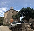
- Saint-Cierge church
- Protestant Church
- War memorial
- Military cemetery

Saint-Cierge church
Protestant Church

War memorial
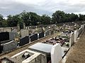
Military cemetery
.JPG)
.JPG)
.JPG)
.JPG)
Web links
Commons : Saint-Cierge-la-Serre - Collection of images, videos and audio files