
Marcols-les-Eaux
| Marcols-les-Eaux | ||
|---|---|---|
|
||
| region | Auvergne-Rhône-Alpes | |
| Department | Ardèche | |
| Arrondissement | Privas | |
| Canton | Haut-Eyrieux | |
| Community association | Privas Center Ardèche | |
| Coordinates | 44 ° 49 ′ N , 4 ° 24 ′ E | |
| height | 671-1,345 m | |
| surface | 16 km 2 | |
| Residents | 296 (January 1, 2017) | |
| Population density | 19 inhabitants / km 2 | |
| Post Code | 07190 | |
| INSEE code | 07149 | |
| Website | www.marcols-les-eaux.fr | |
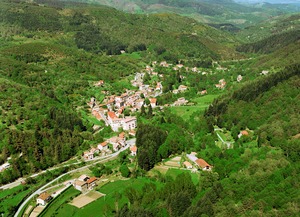 Place view |
||

Marcols-les-Eaux is a French municipality with 296 inhabitants (at January 1, 2017) in the region of Auvergne Rhône-Alpes . It is located in the Ardèche department . Its inhabitants are called Marcolais (es) .
geography
The commune of Marcols-les-Eaux extends between the Boutières massif , part of the Cevennes , and the Eyrieux valley . It is part of the Monts d'Ardèche Regional Nature Park . Neighboring municipalities are Saint-Pierreville and Albon-d'Ardèche . The next largest city is Privas , 20 kilometers south-east. The municipality is traversed by the river Glueyre . The chestnut forests form a defining element of the landscape in and around Marcols-les-Eaux.
history
Known in the 11th century under the name Marcovolos, then in the 12th century under Marcouls, it became the municipality of Saint-Julien-d'Ursival (first documented mention in 1573). Around 1464 the community had 64 inhabitants. In 1790 the parish was renamed Marcols and finally in 1912 Marcols-les-Eaux. The name came about because several mineral water springs gushed and were also used commercially. In the same year (1912) Albon split off from the municipality of Marcols-les-Eaux in order to found its own municipality. The outstanding event in World War II was when, on November 4, 1943, a lost Royal Air Force plane with parachutists on board crashed into Mount Bourboulas above Marcols-les-Eaux. Six tombstones in the Marcols-les-Eaux cemetery still remind of this accident. There is also a granite plaque commemorating the bombing by the Germans with 3 dead civilians on August 7, 1944. The story of Marcols and Albon is closely linked to that of Protestantism in France. The executions that were carried out there after the revocation of the Edict of Nantes are remembered everywhere.
Population development
| year | 1962 | 1968 | 1975 | 1982 | 1990 | 1999 | 2007 | 2016 |
| Residents | 601 | 454 | 353 | 325 | 300 | 301 | 330 | 304 |
| Sources: Cassini and INSEE | ||||||||
Worth seeing
Around the "Champ de Mars" ( 1343 m ) there are several circular hiking trails that connect to the Col de Mézillac and the Col de Faye in the direction of the extinct volcano La Graveyre . In the vicinity you will find the Loire springs at Mont Gerbier-de-Jonc and the Ray-Pic waterfall and Lake Issarlès.
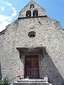
church

cross
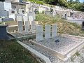
Cemetery with the six gravestones from the 1943 Royal Air Force accident


Web links
- Official website of the municipality (French)