Saint-Thomé
| Saint-Thomé | ||
|---|---|---|
|
|
||
| region | Auvergne-Rhône-Alpes | |
| Department | Ardèche | |
| Arrondissement | Privas | |
| Canton | Berg-Helvie | |
| Community association | Ardèche Rhône Coiron | |
| Coordinates | 44 ° 30 ′ N , 4 ° 38 ′ E | |
| height | 93-380 m | |
| surface | 19.65 km 2 | |
| Residents | 445 (January 1, 2017) | |
| Population density | 23 inhabitants / km 2 | |
| Post Code | 07220 | |
| INSEE code | 07300 | |
| Website | www.saint-thome.fr | |
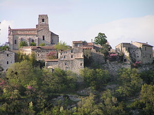
 Village view |
||
Saint-Thomé is a French municipality with 445 inhabitants (at January 1, 2017) in the department of Ardèche in the Region Auvergne Rhône-Alpes ; it belongs to the Arrondissement Privas and the canton Berg-Helvie .
geography
Saint-Thomé is located in a low mountain range about 10 km west of the Rhone between Le Teil and Alba-la-Romaine . The village is on a hill on the right bank of the Escoutay .
population
| year | 1962 | 1968 | 1975 | 1982 | 1990 | 1999 | 2007 | 2017 |
|---|---|---|---|---|---|---|---|---|
| Residents | 288 | 288 | 245 | 257 | 285 | 358 | 386 | 445 |
Web links
Commons : Saint-Thomé - collection of images, videos and audio files
