Saint-Jean-Chambre
| Saint-Jean-Chambre | ||
|---|---|---|
|
|
||
| region | Auvergne-Rhône-Alpes | |
| Department | Ardèche | |
| Arrondissement | Privas | |
| Canton | Rhône-Eyrieux | |
| Community association | Privas Center Ardèche | |
| Coordinates | 44 ° 54 ' N , 4 ° 34' E | |
| height | 388-907 m | |
| surface | 15.26 km 2 | |
| Residents | 265 (January 1, 2017) | |
| Population density | 17 inhabitants / km 2 | |
| Post Code | 07240 | |
| INSEE code | 07244 | |
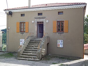
 The Mairie |
||
Saint-Jean-Chambre is a French commune in the Ardèche and in the district Privas in the region Auvergne Rhône-Alpes . The village, an average of 750 meters above sea level in the east of the Massif Central , belonged to the canton of Vernoux-en-Vivarais and was converted into the canton of Rhône-Eyrieux by the reorganization of the French cantons in 2015 . It borders in the north on Saint-Basile , in the northeast on Saint-Apollinaire-de-Rias , in the southeast on Silhac , in the southwest on Chalencon and in the west on Belsentes with Saint-Julien-Labrousse .
Population development
| year | 1962 | 1968 | 1975 | 1982 | 1990 | 1999 | 2008 | 2014 |
|---|---|---|---|---|---|---|---|---|
| Residents | 365 | 333 | 284 | 260 | 235 | 246 | 252 | 276 |
Personalities
Web links
Commons : Saint-Jean-Chambre - collection of images, videos and audio files

