
Silhac
| Silhac | ||
|---|---|---|
|
||
| region | Auvergne-Rhône-Alpes | |
| Department | Ardèche | |
| Arrondissement | Privas | |
| Canton | Rhône-Eyrieux | |
| Community association | Privas Center Ardèche | |
| Coordinates | 44 ° 53 ' N , 4 ° 36' E | |
| height | 270-880 m | |
| surface | 22.71 km 2 | |
| Residents | 368 (January 1, 2017) | |
| Population density | 16 inhabitants / km 2 | |
| Post Code | 07240 | |
| INSEE code | 07314 | |
| Website | http://www.silhac.fr/ | |

Silhac ( Occitan identical) is a French municipality with 368 inhabitants (as of January 1 2017) in the department of Ardèche in the Region Auvergne Rhône-Alpes . Silhac is part of the Arrondissement Privas and the canton of Rhône-Eyrieux . The inhabitants are called Saint-Laurentais (es) .
geography
Silhac is about 21 kilometers west-southwest of Valence . Silhac is surrounded by the neighboring municipalities of Saint-Apollinaire-de-Rias in the north, Vernoux-en-Vivarais in the north and north-east, Saint-Julien-le-Roux in the east and south-east, Dunière-sur-Eyrieux in the south-east, Saint-Michel- de-Chabrillanoux in the south, Saint-Maurice-en-Chalencon in the south and south-west, Chalencon in the west and south-west and Saint-Jean-Chambre in the north-west.
Population development
| 1962 | 1968 | 1975 | 1982 | 1990 | 1999 | 2006 | 2013 |
|---|---|---|---|---|---|---|---|
| 603 | 487 | 353 | 337 | 286 | 312 | 338 | 367 |
| Source: Cassini and INSEE | |||||||
Attractions
- Catholic Church of Notre-Dame-de-l'Assomption
- Evangelical Reformed Church
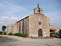
Notre-Dame-de-l'Assomption church

Evangelical Reformed Church

.jpg)