Larnas
| Larnas | ||
|---|---|---|

|
|
|
| region | Auvergne-Rhône-Alpes | |
| Department | Ardèche | |
| Arrondissement | Privas | |
| Canton | Bourg-Saint-Andéol | |
| Community association | Rhône aux Gorges de l'Ardèche | |
| Coordinates | 44 ° 27 ' N , 4 ° 36' E | |
| height | 120-364 m | |
| surface | 13.50 km 2 | |
| Residents | 238 (January 1, 2017) | |
| Population density | 18 inhabitants / km 2 | |
| Post Code | 07220 | |
| INSEE code | 07133 | |
| Website | www.larnas.fr | |
 Village de Larnas |
||
Larnas is a French commune with 238 inhabitants (as of January 1, 2017) in the Ardèche department . It belongs to the Rhône aux Gorges de l'Ardèche municipal association .
geography
The municipality is located 8.1 kilometers southwest of Viviers on the banks of the Rhone and about 15 kilometers northeast of Vallon-Pont-d'Arc on the Ardèche on a high plateau in the wine-growing region of Côtes du Vivarais . The Nègue flows through the municipality.
Population development
| year | 1962 | 1968 | 1975 | 1982 | 1990 | 1999 | 2007 | 2017 |
| Residents | 54 | 52 | 56 | 83 | 70 | 90 | 91 | 238 |
| Sources: Cassini and INSEE | ||||||||
Attractions
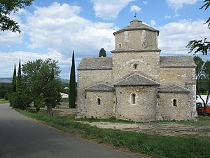
The Romanesque church of Saint-Pierre dates from the 11th and 12th centuries and has been classified as a Monument historique since 1907 .
economy
The image of the community is characterized by fields, meadows and lavender fields. To the south lies the large Bois de Laoul forest . Viticulture is an important line of business , and tourism has also gained in importance thanks to the Le Domaine d'Imbours holiday center in the hamlet of Imbours . Local products include wines from the AOC Côtes du Vivarais and Comtés Rhodania , truffles and lavender .
Web links
Individual evidence
- ↑ Larnas in the Base Mérimée of the Ministry of Culture (French) Retrieved on 12 May 2010
- ^ Website of the Le Domaine d'Imbours holiday center (French). Accessed October 30, 2009
- ↑ Larnas on aoc-igp.fr (French). Retrieved March 28, 2015.
