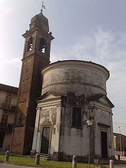
Sanguinetto
| Sanguinetto | ||
|---|---|---|

|
|
|
| Country | Italy | |
| region | Veneto | |
| province | Verona (VR) | |
| Local name | Sanguine | |
| Coordinates | 45 ° 11 ' N , 11 ° 9' E | |
| height | 19 m slm | |
| surface | 13.63 km² | |
| Residents | 4,119 (Dec. 31, 2019) | |
| Population density | 302 inhabitants / km² | |
| Post Code | 37058 | |
| prefix | 0442 | |
| ISTAT number | 023072 | |
| Popular name | Sanguinettani or Sanguinettensi | |
| Patron saint | George | |
| Website | Sanguinetto | |
Sanguinetto is a north-east Italian municipality ( comune ) with 4119 inhabitants (as of December 31, 2019) in the province of Verona in Veneto . The municipality is located about 31.5 kilometers south-southeast of Verona .
history
A scaliger castle from the 14th century has been preserved in Sanguinetto . In 1232 Sanguinetto was destroyed by Mantua's army . Several times, when Sanguinetto came to the Republic of Venice , the town was attacked. In 1483 by Ferrara, in 1509 by the imperial armies and in 1511 by the French, who destroyed the place.
In the 17th century the peculiar Chiesa della Rotonda was built.
traffic
Sanguinetto is located on the former Strada Statale 10 Padana Inferiore (today a regional road) between Mantua and Padua . The Sanguinettos train station is on the railway line from Mantua to Monselice .
Personalities
- Renato Olivieri (1925–2013), writer and journalist
- Gino Pivatelli (* 1933), football player and coach
See also
- Paolo dalla Torre (1910–1993), Conte from Sanguinetto
- Giuseppe Dalla Torre del Tempio di Sanguinetto (* 1943), legal scholar and general governor of the Order of Knights of the Holy Sepulcher in Jerusalem
- Giacomo Dalla Torre del Tempio di Sanguinetto (1944–2020), literary scholar and Grand Master of the Order of Malta
Web links
Individual evidence
- ↑ Statistiche demografiche ISTAT. Monthly population statistics of the Istituto Nazionale di Statistica , as of December 31 of 2019.


